| Locality | Latitude | Longitude | Distance | Bearing |
|---|
| Sphalerite and Galena Occurrence Z84 Occurrence, Newton County, Indiana, USA | 40° 45' 39" N | 87° 23' 30" W | 5.0km (3.1 miles) | |
| Newton County Stone Quarry (Kentland Quarry), Kentland impact crater (Kentland crater), Kentland (Kent), Newton County, Indiana, USA | 40° 45' 50" N | 87° 23' 16" W | 5.1km (3.2 miles) | |
| Kentland (Kent), Newton County, Indiana, USA | 40° 46' 13" N | 87° 26' 43" W | 8.7km (5.4 miles) | |
| Benton County Highway Department, Benton County, Indiana, USA | 40° 37' 23" N | 87° 19' 5" W | 11.6km (7.2 miles) | |
| Newton County Highway Department, Newton County, Indiana, USA | 40° 56' 53" N | 87° 27' 15" W | 26.3km (16.3 miles) | |
| Babcock Quarry, Jasper County, Indiana, USA | 40° 55' 54" N | 87° 8' 43" W | 29.7km (18.4 miles) | |
| Jasper County Highway Department, Jasper County, Indiana, USA | 40° 56' 30" N | 87° 9' 0" W | 30.3km (18.8 miles) | |
| Iroquis County Highway Department pit, Iroquois County, Illinois, USA | 40° 46' 36" N | 87° 43' 54" W | 31.6km (19.6 miles) | |
| Watseka City Engineering Pit, Iroquois County, Illinois, USA | 40° 46' 36" N | 87° 43' 54" W | 31.6km (19.6 miles) | |
| Sphalerite and Galena Occurrence, Jasper County, Indiana, USA | 40° 56' 15" N | 87° 5' 44" W | 32.9km (20.4 miles) | |
| Pleasant Ridge, Jasper County, Indiana, USA | 40° 56' 1" N | 87° 4' 27" W | 33.9km (21.0 miles) | |
| Rensselaer Quarry, Pleasant Ridge, Jasper County, Indiana, USA | 40° 56' 9" N | 87° 4' 18" W | 34.2km (21.2 miles) | |
| Rainsville, Warren County, Indiana, USA | 40° 24' 56" N | 87° 18' 56" W | 34.3km (21.3 miles) | |
| Mud Pine Creek, Rainsville, Warren County, Indiana, USA | 40° 24' 49" N | 87° 20' 36" W | 34.3km (21.3 miles) | |
| White County Highway Department, White County, Indiana, USA | 40° 45' 0" N | 86° 52' 23" W | 41.4km (25.7 miles) | |
| Vulcan Materials Company Quarry - Monon Plant, Monon, White County, Indiana, USA | 40° 50' 30" N | 86° 52' 59" W | 42.6km (26.4 miles) | |
| Monon Crushed Stone Company Quarry, Monon, White County, Indiana, USA | 40° 52' 0" N | 86° 52' 45" W | 43.8km (27.2 miles) | |
| Eastern Illinois Pit & Mill, Kankakee County, Illinois, USA | 41° 1' 21" N | 87° 42' 28" W | 44.2km (27.5 miles) | |
| Ward Stone Company, Pulaski County, Indiana, USA | 40° 56' 53" N | 86° 53' 17" W | 47.2km (29.3 miles) | |
| Rostone Pit, Fountain County, Indiana, USA | 40° 19' 57" N | 87° 7' 56" W | 47.5km (29.5 miles) | |
| Vulcan Materials Company Quarry - Francesville Plant, Francesville, Pulaski County, Indiana, USA | 40° 57' 39" N | 86° 53' 8" W | 48.2km (29.9 miles) | |
| Attica, Fountain County, Indiana, USA | 40° 17' 39" N | 87° 14' 56" W | 48.5km (30.2 miles) | |
| Keeport Quarry, Cass County, Indiana, USA | 40° 45' 38" N | 86° 46' 54" W | 49.2km (30.6 miles) | |
| Lehigh Main Quarry, Kankakee County, Illinois, USA | 41° 6' 27" N | 87° 39' 15" W | 49.4km (30.7 miles) | |
| Francesville, Pulaski County, Indiana, USA | 40° 59' 7" N | 86° 52' 46" W | 50.1km (31.2 miles) | |
| West Lebanon, Warren County, Indiana, USA | 40° 16' 12" N | 87° 23' 12" W | 50.3km (31.3 miles) | |
| Francesville Clay Pit (Francesville Drain Tile Corp.), Pulaski County, Indiana, USA | 41° 0' 23" N | 86° 52' 50" W | 51.5km (32.0 miles) | |
| Rostone Corporation Lafayette Operations, Tippecanoe County, Indiana, USA | 40° 25' 12" N | 86° 53' 35" W | 52.0km (32.3 miles) | |
| Lafayette (stone) Martian meteorite, Lafayette, Tippecanoe County, Indiana, USA | 40° 25' 0" N | 86° 52' 59" W | 52.9km (32.9 miles) | |
| Momence Quarry & Mill (Momence Quarry), Kankakee County, Illinois, USA | 41° 11' 27" N | 87° 34' 28" W | 55.1km (34.2 miles) | |

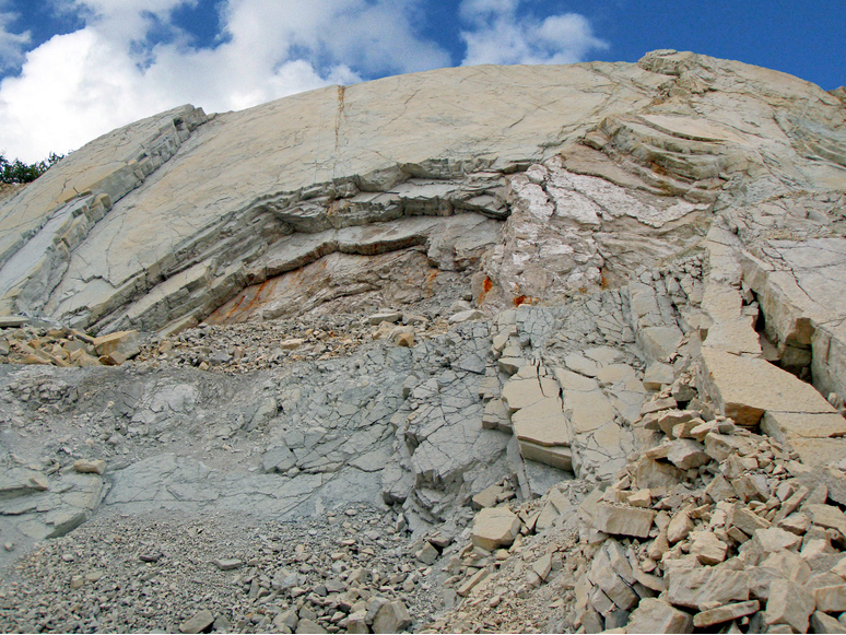


Newton County Stone Quarry, Kentland impact crater, Kentland, Newton County, Indiana, USA