| Locality | Latitude | Longitude | Distance | Bearing |
|---|
| Grant Peak, Ossipee, Carroll County, New Hampshire, USA | 43° 48' 3" N | 71° 12' 54" W | 7.2km (4.5 miles) | |
| Ossipee, Carroll County, New Hampshire, USA | 43° 41' 4" N | 71° 7' 1" W | 8.3km (5.2 miles) | |
| Green Mountain Locality, Effingham, Carroll County, New Hampshire, USA | 43° 46' 2" N | 71° 2' 12" W | 9.3km (5.8 miles) | |
| Bald Mountain, Ossipee, Carroll County, New Hampshire, USA | 43° 48' 2" N | 71° 15' 57" W | 10.5km (6.5 miles) | |
| Madison Lead Mine, Madison, Carroll County, New Hampshire, USA | 43° 51' 15" N | 71° 9' 15" W | 11.0km (6.8 miles) | |
| Freedom, Carroll County, New Hampshire, USA | 43° 48' 48" N | 71° 2' 11" W | 11.3km (7.0 miles) | |
| Effingham, Carroll County, New Hampshire, USA | 43° 45' 39" N | 70° 59' 47" W | 12.5km (7.8 miles) | |
| Ossipee Aggregates Corp. quarry, Ossipee, Carroll County, New Hampshire, USA | 43° 39' 19" N | 71° 2' 45" W | 14.0km (8.7 miles) | |
| Tamworth, Carroll County, New Hampshire, USA | 43° 51' 33" N | 71° 15' 46" W | 14.6km (9.1 miles) | |
| Mineral Hill Mine, Wakefield, Carroll County, New Hampshire, USA | 43° 40' 26" N | 71° 0' 29" W | 14.7km (9.1 miles) | |
| Ham and Weeks Mine, Wakefield, Carroll County, New Hampshire, USA | 43° 40' 9" N | 71° 0' 31" W | 15.0km (9.3 miles) | |
| Bank Mine, Madison, Carroll County, New Hampshire, USA | 43° 53' 30" N | 71° 9' 29" W | 15.2km (9.4 miles) | |
| Madison, Carroll County, New Hampshire, USA | 43° 54' 14" N | 71° 8' 49" W | 16.6km (10.3 miles) | |
| Parsonsfield Vesuvianite locality, Parsonsfield, York County, Maine, USA | 43° 45' 38" N | 70° 56' 14" W | 17.3km (10.7 miles) | |
| Parsonsfield, York County, Maine, USA | 43° 43' 36" N | 70° 55' 46" W | 18.2km (11.3 miles) | |
| Moultonborough, Carroll County, New Hampshire, USA | 43° 45' 18" N | 71° 23' 47" W | 19.6km (12.2 miles) | |
| Sandwich, Carroll County, New Hampshire, USA | 43° 47' 26" N | 71° 24' 39" W | 21.2km (13.2 miles) | |
| Kezar Falls Mine, Parsonsfield, York County, Maine, USA | 43° 47' 54" N | 70° 53' 25" W | 21.6km (13.4 miles) | |
| Albany, Carroll County, New Hampshire, USA | 43° 57' 28" N | 71° 10' 3" W | 22.6km (14.0 miles) | |
| Wakefield, Carroll County, New Hampshire, USA | 43° 34' 5" N | 71° 1' 48" W | 23.0km (14.3 miles) | |
| Davis mine, Newfield, York County, Maine, USA | 43° 36' 45" N | 70° 55' 38" W | 24.0km (14.9 miles) | |
| Bond Mountain prospect, Newfield, York County, Maine, USA | 43° 37' 52" N | 70° 54' 20" W | 24.1km (15.0 miles) | |
| Piper Hill prospect, Newfield, York County, Maine, USA | 43° 39' 41" N | 70° 52' 43" W | 24.3km (15.1 miles) | |
| Red Hill, Moultonborough, Carroll County, New Hampshire, USA | 43° 45' 20" N | 71° 27' 30" W | 24.6km (15.3 miles) | |
| Conway, Carroll County, New Hampshire, USA | 43° 58' 42" N | 71° 7' 8" W | 25.0km (15.5 miles) | |
| Horne Quarry, Red Hill, Moultonborough, Carroll County, New Hampshire, USA | 43° 44' 30" N | 71° 27' 47" W | 25.1km (15.6 miles) | |
| Symmes Pond Syenite, Straw Hill occurrence, Newfield, York County, Maine, USA | 43° 39' 39" N | 70° 51' 50" W | 25.4km (15.8 miles) | |
| Knox Mountain Granite quarry, Newfield, York County, Maine, USA | 43° 38' 24" N | 70° 52' 35" W | 25.6km (15.9 miles) | |
| Bergendahl prospect, Newfield, York County, Maine, USA | 43° 39' 5" N | 70° 52' 1" W | 25.6km (15.9 miles) | |
| Day Hill, Cornish, York County, Maine, USA | 43° 45' 9" N | 70° 49' 52" W | 25.8km (16.0 miles) | |

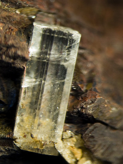


Bald Mountain, Ossipee, Carroll County, New Hampshire, USA