| Locality | Latitude | Longitude | Distance | Bearing |
|---|
| Crotched Mountain, Francestown, Hillsborough County, New Hampshire, USA | 42° 59' 53" N | 71° 52' 26" W | 5.3km (3.3 miles) | |
| Rose Mountain, Lyndeborough, Hillsborough County, New Hampshire, USA | 42° 55' 54" N | 71° 48' 16" W | 5.9km (3.7 miles) | |
| Francestown, Hillsborough County, New Hampshire, USA | 42° 59' 14" N | 71° 48' 45" W | 6.4km (4.0 miles) | |
| Hancock, Hillsborough County, New Hampshire, USA | 42° 58' 22" N | 71° 58' 46" W | 9.1km (5.6 miles) | |
| Lyndeborough, Hillsborough County, New Hampshire, USA | 42° 54' 26" N | 71° 45' 59" W | 9.9km (6.1 miles) | |
| Antrim, Hillsborough County, New Hampshire, USA | 43° 1' 50" N | 71° 56' 20" W | 10.4km (6.5 miles) | |
| Peterborough, Hillsborough County, New Hampshire, USA | 42° 52' 14" N | 71° 57' 6" W | 11.0km (6.8 miles) | |
| Wilton Crushed Stone Quarry, Wilton, Hillsborough County, New Hampshire, USA | 42° 52' 11" N | 71° 45' 59" W | 12.4km (7.7 miles) | |
| Granite State Quarry, Wilton, Hillsborough County, New Hampshire, USA | 42° 51' 50" N | 71° 45' 45" W | 13.2km (8.2 miles) | |
| Deering, Hillsborough County, New Hampshire, USA | 43° 4' 23" N | 71° 50' 39" W | 13.8km (8.6 miles) | |
| New Boston, Hillsborough County, New Hampshire, USA | 42° 58' 32" N | 71° 41' 30" W | 15.0km (9.3 miles) | |
| Dublin, Cheshire County, New Hampshire, USA | 42° 54' 20" N | 72° 3' 38" W | 16.1km (10.0 miles) | |
| Wilton, Hillsborough County, New Hampshire, USA | 42° 50' 35" N | 71° 44' 5" W | 16.4km (10.2 miles) | |
| Harrisville, Cheshire County, New Hampshire, USA | 42° 56' 42" N | 72° 5' 47" W | 18.2km (11.3 miles) | |
| Hillsborough, Hillsborough County, New Hampshire, USA | 43° 6' 52" N | 71° 53' 41" W | 18.3km (11.4 miles) | |
| New Westerly Quarry, Milford, Hillsborough County, New Hampshire, USA | 42° 51' 10" N | 71° 41' 14" W | 18.6km (11.5 miles) | |
| Carlton Quarry, Milford, Hillsborough County, New Hampshire, USA | 42° 51' 13" N | 71° 41' 5" W | 18.7km (11.6 miles) | |
| Campbell Mountain Mine, Antrim, Hillsborough County, New Hampshire, USA | 43° 5' 56" N | 71° 58' 51" W | 18.7km (11.6 miles) | |
| Bishop Quarry, Milford, Hillsborough County, New Hampshire, USA | 42° 51' 10" N | 71° 40' 41" W | 19.2km (11.9 miles) | |
| Jaffrey, Cheshire County, New Hampshire, USA | 42° 48' 50" N | 72° 1' 23" W | 19.5km (12.1 miles) | |
| Weare, Hillsborough County, New Hampshire, USA | 43° 5' 40" N | 71° 43' 50" W | 19.7km (12.3 miles) | |
| Sulphur Hill mine, Hillsborough, Hillsborough County, New Hampshire, USA | 43° 6' 43" N | 71° 58' 54" W | 20.0km (12.5 miles) | |
| Osgood Graphite Mine, Nelson, Cheshire County, New Hampshire, USA | 42° 59' 38" N | 72° 6' 48" W | 20.2km (12.6 miles) | |
| Nelson, Cheshire County, New Hampshire, USA | 42° 59' 21" N | 72° 7' 40" W | 21.2km (13.2 miles) | |
| Monadnock Mountain, Jaffrey, Cheshire County, New Hampshire, USA | 42° 51' 39" N | 72° 6' 33" W | 21.7km (13.5 miles) | |
| Burns Hill area, Milford, Hillsborough County, New Hampshire, USA | 42° 48' 26" N | 71° 41' 25" W | 21.8km (13.5 miles) | |
| Graphite mine, Monadnock Mountain, Jaffrey, Cheshire County, New Hampshire, USA | 42° 51' 29" N | 72° 6' 33" W | 21.9km (13.6 miles) | |
| Fletcher Granite Quarry, Mason, Hillsborough County, New Hampshire, USA | 42° 46' 49" N | 71° 43' 53" W | 22.2km (13.8 miles) | |
| Milford, Hillsborough County, New Hampshire, USA | 42° 50' 7" N | 71° 38' 56" W | 22.3km (13.8 miles) | |
| Amherst, Hillsborough County, New Hampshire, USA | 42° 51' 41" N | 71° 37' 31" W | 22.4km (13.9 miles) | |

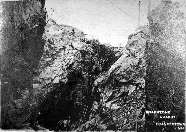


Francestown Soapstone quarry, Francestown, Hillsborough County, New Hampshire, USA