| Locality | Latitude | Longitude | Distance | Bearing |
|---|
| Gray Rocks Lode, Custer Mining District, Custer County, South Dakota, USA | 43° 44' 55" N | 103° 36' 45" W | 0.4km (0.2 miles) | |
| Lucky Star Prospect, Custer Mining District, Custer County, South Dakota, USA | 43° 44' 55" N | 103° 36' 45" W | 0.4km (0.2 miles) | |
| Rte. 85A South, Custer, Custer Mining District, Custer County, South Dakota, USA | 43° 44' 43" N | 103° 36' 39" W | 0.6km (0.4 miles) | |
| Big Time Lode Prospect, Custer Mining District, Custer County, South Dakota, USA | 43° 45' 0" N | 103° 36' 26" W | 0.8km (0.5 miles) | |
| Rainbow Claim, Custer Mining District, Custer County, South Dakota, USA | 43° 44' 34" N | 103° 36' 40" W | 0.8km (0.5 miles) | |
| White Spar Mica Mine (Westinghouse No. 2 Mine), Custer, Custer Mining District, Custer County, South Dakota, USA | 43° 44' 51" N | 103° 37' 41" W | 0.9km (0.6 miles) | |
| White Dog Mica Mine, Custer Mining District, Custer County, South Dakota, USA | 43° 45' 26" N | 103° 37' 17" W | 1.0km (0.7 miles) | |
| Lucky Spar Lode Occurrence, Custer Mining District, Custer County, South Dakota, USA | 43° 44' 42" N | 103° 36' 9" W | 1.2km (0.8 miles) | |
| Empire Pegmatite Occurrence, Custer Mining District, Custer County, South Dakota, USA | 43° 45' 12" N | 103° 37' 57" W | 1.4km (0.8 miles) | |
| Dorothy Lode, Custer Mining District, Custer County, South Dakota, USA | 43° 45' 14" N | 103° 38' 1" W | 1.5km (0.9 miles) | |
| Heidepriem and Cattles Mine, Custer Mining District, Custer County, South Dakota, USA | 43° 44' 13" N | 103° 36' 26" W | 1.5km (0.9 miles) | |
| Dorothy No. 1 Lode Occurrence, Custer Mining District, Custer County, South Dakota, USA | 43° 45' 19" N | 103° 38' 1" W | 1.6km (1.0 miles) | |
| Aladdin Mine, Custer Mining District, Custer County, South Dakota, USA | 43° 45' 12" N | 103° 35' 52" W | 1.6km (1.0 miles) | |
| Burgess Mica Prospect, Custer Mining District, Custer County, South Dakota, USA | 43° 44' 29" N | 103° 35' 57" W | 1.7km (1.0 miles) | |
| Buster lode (Buster Dike Mica Mine), Custer, Custer Mining District, Custer County, South Dakota, USA | 43° 43' 59" N | 103° 36' 58" W | 1.7km (1.1 miles) | |
| Diamond Quartz Lode, Custer Mining District, Custer County, South Dakota, USA | 43° 45' 48" N | 103° 37' 30" W | 1.8km (1.1 miles) | |
| Unnamed Garnet occurrence, Custer, Custer Mining District, Custer County, South Dakota, USA | 43° 44' 19" N | 103° 35' 51" W | 1.9km (1.2 miles) | |
| Ridge Lode Occurrence, Custer Mining District, Custer County, South Dakota, USA | 43° 45' 24" N | 103° 38' 28" W | 2.1km (1.3 miles) | |
| Dorothy V Prospect (Van), Custer Mining District, Custer County, South Dakota, USA | 43° 45' 29" N | 103° 38' 26" W | 2.2km (1.4 miles) | |
| Bull Head and Roosevelt Lodes Prospect, Custer Mining District, Custer County, South Dakota, USA | 43° 43' 39" N | 103° 36' 45" W | 2.4km (1.5 miles) | |
| White Bear Mine (Gamber Mine), Custer, Custer Mining District, Custer County, South Dakota, USA | 43° 43' 38" N | 103° 36' 43" W | 2.4km (1.5 miles) | |
| Pine Top Lode, Custer Mining District, Custer County, South Dakota, USA | 43° 43' 36" N | 103° 36' 51" W | 2.4km (1.5 miles) | |
| Bebington Group, Unorganized mining district [1], Custer County, South Dakota, USA | 43° 44' 35" N | 103° 38' 52" W | 2.5km (1.6 miles) | |
| Raver and Michaud Mine, Custer Mining District, Custer County, South Dakota, USA | 43° 45' 31" N | 103° 38' 45" W | 2.6km (1.6 miles) | |
| Virginia Mine, Custer County, South Dakota, USA | 43° 46' 9" N | 103° 35' 59" W | 2.7km (1.7 miles) | |
| Hub Mine, Custer Mining District, Custer County, South Dakota, USA | 43° 43' 24" N | 103° 37' 13" W | 2.8km (1.7 miles) | |
| Silver Dollar Mine, Custer Mining District, Custer County, South Dakota, USA | 43° 43' 22" N | 103° 36' 57" W | 2.9km (1.8 miles) | |
| Evergreen Group (Evergreen No. 1), Custer Mining District, Custer County, South Dakota, USA | 43° 43' 51" N | 103° 35' 20" W | 3.0km (1.9 miles) | |
| Pine Top Fraction Lode Occurrence, Custer Mining District, Custer County, South Dakota, USA | 43° 43' 17" N | 103° 36' 51" W | 3.0km (1.9 miles) | |
| Mineral Hill Lode (Oneota Lode), Unorganized mining district [1], Custer County, South Dakota, USA | 43° 46' 20" N | 103° 38' 23" W | 3.2km (2.0 miles) | |
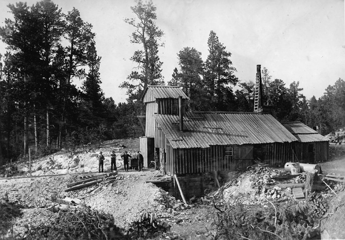


White Spar Mica Mine, Custer, Custer Mining District, Custer County, South Dakota, USA