| Locality | Latitude | Longitude | Distance | Bearing |
|---|
| Slavonian Mine (Glover Mine), Lead Mining District, Lawrence County, South Dakota, USA | 44° 21' 15" N | 103° 44' 40" W | 0.0km (0.0 miles) | |
| Rex Mine, Lead Mining District, Lawrence County, South Dakota, USA | 44° 21' 0" N | 103° 45' 0" W | 0.6km (0.4 miles) | |
| Whitewood Creek placers, Lead Mining District, Lawrence County, South Dakota, USA | 44° 20' 59" N | 103° 45' 0" W | 0.6km (0.4 miles) | |
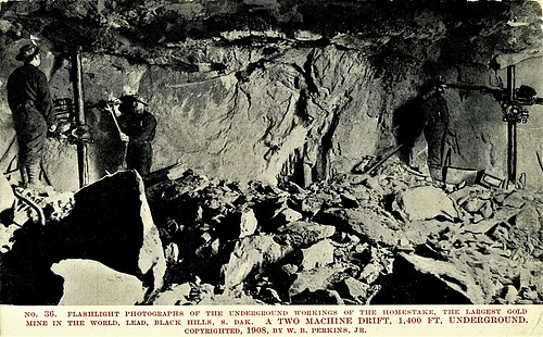
| Homestake Mill, Lead Mining District, Lawrence County, South Dakota, USA | 44° 21' 17" N | 103° 45' 9" W | 0.6km (0.4 miles) | |
| Pluma, Lead Mining District, Lawrence County, South Dakota, USA | 44° 21' 31" N | 103° 44' 24" W | 0.6km (0.4 miles) | |
| Strawberry Creek, Lawrence County, South Dakota, USA | 44° 20' 52" N | 103° 43' 59" W | 1.2km (0.7 miles) | |
| Deadwood Gulch, Deadwood, Galena Mining District, Lawrence County, South Dakota, USA | 44° 21' 44" N | 103° 44' 8" W | 1.2km (0.7 miles) | |
| Deadwood Gulch, Lead Mining District, Lawrence County, South Dakota, USA | 44° 21' 45" N | 103° 44' 8" W | 1.2km (0.7 miles) | |
| Gentle Annie Mine, Lead Mining District, Lawrence County, South Dakota, USA | 44° 21' 39" N | 103° 45' 22" W | 1.2km (0.7 miles) | |
| Best Placer, Lead Mining District, Lawrence County, South Dakota, USA | 44° 21' 42" N | 103° 44' 1" W | 1.2km (0.8 miles) | |
| Hawkeye-Pluma Mine, Lead Mining District, Lawrence County, South Dakota, USA | 44° 21' 41" N | 103° 45' 22" W | 1.2km (0.8 miles) | |
| Phoenix-Minerva Mine, Blacktail Gulch, Lead Mining District, Lawrence County, South Dakota, USA | 44° 21' 59" N | 103° 45' 0" W | 1.4km (0.9 miles) | |
| Susa Fractional Claim (Frerichs Mining Company), Lead Mining District, Lawrence County, South Dakota, USA | 44° 21' 32" N | 103° 43' 39" W | 1.5km (0.9 miles) | |
| Monitor Mine, Lead Mining District, Lawrence County, South Dakota, USA | 44° 21' 30" N | 103° 45' 44" W | 1.5km (0.9 miles) | |
| Homestake Mine, Lead, Lead Mining District, Lawrence County, South Dakota, USA | 44° 21' 20" N | 103° 45' 54" W | 1.6km (1.0 miles) | |
| Queen of the Hills Mine, Lead Mining District, Lawrence County, South Dakota, USA | 44° 21' 30" N | 103° 43' 29" W | 1.7km (1.0 miles) | |
| Montezuma mine, Deadwood, Galena Mining District, Lawrence County, South Dakota, USA | 44° 22' 11" N | 103° 44' 34" W | 1.8km (1.1 miles) | |
| Lead Mining District, Lawrence County, South Dakota, USA | 44° 20' 59" N | 103° 46' 0" W | 1.8km (1.1 miles) | |
| Olaf Seim Mine (Gotland Mine; Broken Boot), Deadwood, Galena Mining District, Lawrence County, South Dakota, USA | 44° 22' 14" N | 103° 44' 32" W | 1.8km (1.1 miles) | |
| Oro Hondo Mine, Lead Mining District, Lawrence County, South Dakota, USA | 44° 20' 14" N | 103° 44' 37" W | 1.9km (1.2 miles) | |
| Bobtail Gulch, Lead Mining District, Lawrence County, South Dakota, USA | 44° 22' 6" N | 103° 45' 42" W | 2.1km (1.3 miles) | |
| Baltimore & Deadwood, Lead Mining District, Lawrence County, South Dakota, USA | 44° 22' 14" N | 103° 45' 31" W | 2.1km (1.3 miles) | |
| Deadwood - Golden Terra Mine (Deadwood Terra), Lead Mining District, Lawrence County, South Dakota, USA | 44° 21' 53" N | 103° 46' 3" W | 2.1km (1.3 miles) | |
| Pinney Mine, Lead Mining District, Lawrence County, South Dakota, USA | 44° 22' 6" N | 103° 45' 48" W | 2.2km (1.4 miles) | |
| Durango mine (Harrison), Hidden Fortune Mines, Lead Mining District, Lawrence County, South Dakota, USA | 44° 21' 0" N | 103° 46' 19" W | 2.2km (1.4 miles) | |
| Lead, Lead Mining District, Lawrence County, South Dakota, USA | 44° 21' 2" N | 103° 46' 20" W | 2.2km (1.4 miles) | |
| Omega Mine, Lead Mining District, Lawrence County, South Dakota, USA | 44° 21' 59" N | 103° 46' 6" W | 2.3km (1.4 miles) | |
| Homestake Tungsten Properties, Lead Mining District, Lawrence County, South Dakota, USA | 44° 21' 20" N | 103° 46' 27" W | 2.3km (1.4 miles) | |
| Blacktail Gulch, Lead Mining District, Lawrence County, South Dakota, USA | 44° 22' 17" N | 103° 45' 40" W | 2.3km (1.4 miles) | |
| Etta Mine, Lead Mining District, Lawrence County, South Dakota, USA | 44° 20' 11" N | 103° 45' 49" W | 2.5km (1.5 miles) | |


Homestake Mine, Lead, Lead Mining District, Lawrence County, South Dakota, USA