| Locality | Latitude | Longitude | Distance | Bearing |
|---|
| Hodge's Canyon Occurrence (Lead Hill), Bear Lake Area, Rich County, Utah, USA | 41° 55' 0" N | 111° 26' 58" W | 5.7km (3.6 miles) | |
| Bear Lake Summit Limestone Pit, Bear Lake, Rich County, Utah, USA | 41° 55' 29" N | 111° 28' 3" W | 6.6km (4.1 miles) | |
| Swan Peak, Rich County, Utah, USA | 41° 58' 48" N | 111° 27' 55" W | 7.0km (4.4 miles) | |
| Unknown Rock Quarry (MRDS - 10101653), Bear Lake, Rich County, Utah, USA | 41° 53' 8" N | 111° 22' 4" W | 7.1km (4.4 miles) | |
| Amazon Mine, Swan Peak Mining District, Cache County, Utah, USA | 41° 56' 52" N | 111° 30' 6" W | 9.0km (5.6 miles) | |
| Amazon Hollow Claim No. 2, Swan Peak Mining District, Cache County, Utah, USA | 41° 57' 17" N | 111° 30' 6" W | 9.0km (5.6 miles) | |
| Deadman Gulch Prospects (Red Bluff), Swan Peak Mining District, Cache County, Utah, USA | 41° 56' 20" N | 111° 30' 24" W | 9.4km (5.9 miles) | |
| Amazon Hollow Claim No. 1, Swan Peak Mining District, Cache County, Utah, USA | 41° 57' 47" N | 111° 30' 20" W | 9.4km (5.9 miles) | |
| Unknown Mine (MRDS - 10087340), Bear River, Rich County, Utah, USA | 41° 51' 14" N | 111° 23' 38" W | 10.3km (6.4 miles) | |
| Major Metals Mining Company Occurrence, Swan Peak Mining District, Cache County, Utah, USA | 41° 57' 21" N | 111° 31' 20" W | 10.7km (6.7 miles) | |
| Unknown Limestone Pit [1], Swan Peak Mining District, Cache County, Utah, USA | 41° 57' 55" N | 111° 31' 41" W | 11.3km (7.0 miles) | |
| Unknown Limestone Pit [2], Swan Peak Mining District, Cache County, Utah, USA | 41° 58' 0" N | 111° 31' 49" W | 11.5km (7.2 miles) | |
| Unknown Pit (MRDS - 10011438), Bear Lake, Rich County, Utah, USA | 41° 55' 6" N | 111° 14' 23" W | 13.1km (8.1 miles) | |
| Unknown Phosphorus-Phosphates Occurrence (MRDS - 10071451), Laketown Mining District, Rich County, Utah, USA | 41° 49' 30" N | 111° 17' 34" W | 15.9km (9.9 miles) | |
| Blackstone Mine, Bear River Range, Bear Lake County, Idaho, USA | 42° 6' 38" N | 111° 27' 1" W | 18.8km (11.7 miles) | |
| Cambrian Dolomite Occurrence (St. Charles Creek Dolomite Deposit), St. Charles Area, Bear Lake County, Idaho, USA | 42° 6' 43" N | 111° 27' 45" W | 19.2km (11.9 miles) | |
| Idaho Gem Group, St. Charles Area, Bear Lake County, Idaho, USA | 42° 7' 21" N | 111° 26' 56" W | 20.1km (12.5 miles) | |
| Unnamed Phosphorus-Phosphates Location (MRDS - 10217060), Bear Lake Area, Bear Lake County, Idaho, USA | 42° 5' 59" N | 111° 15' 12" W | 20.6km (12.8 miles) | |
| Hot Springs Phosphate Deposit (MRDS - 10078033), Bear Lake Area, Bear Lake County, Idaho, USA | 42° 6' 32" N | 111° 15' 22" W | 21.3km (13.2 miles) | |
| Unnamed Phosphorus-Phosphates Location (MRDS - 10305398), Bear Lake Area, Bear Lake County, Idaho, USA | 42° 6' 25" N | 111° 15' 7" W | 21.3km (13.2 miles) | |
| Clark Mine (Sunset Mine), Bloomington, Bear Lake County, Idaho, USA | 42° 8' 51" N | 111° 27' 1" W | 22.8km (14.2 miles) | |
| Unnamed Phosphorus-Phosphates Location (MRDS - 10144140), Bear Lake County, Idaho, USA | 42° 7' 50" N | 111° 15' 44" W | 23.2km (14.4 miles) | |
| Worm Creek Prospect (Wasatch Mining and Development Property), Bloomington, Bear Lake County, Idaho, USA | 42° 9' 2" N | 111° 27' 18" W | 23.2km (14.4 miles) | |
| Unknown Limestone - General Occurrence (MRDS - 10087332), Swan Peak Mining District, Rich County, Utah, USA | 41° 46' 55" N | 111° 12' 56" W | 23.5km (14.6 miles) | |
| Unnamed Phosphorus-Phosphates Location (MRDS - 10192500), Bear Lake County, Idaho, USA | 42° 8' 4" N | 111° 15' 44" W | 23.5km (14.6 miles) | |
| Unnamed Rhenium Location (MRDS - 10216670), Bear Lake County, Idaho, USA | 42° 8' 55" N | 111° 15' 44" W | 24.9km (15.5 miles) | |
| Unnamed Manganese Occurrence (MRDS - 10240873), Bloomington, Bear Lake County, Idaho, USA | 42° 10' 28" N | 111° 25' 35" W | 25.4km (15.8 miles) | |
| Manganese Deposit (MRDS - 10078007), Bloomington, Bear Lake County, Idaho, USA | 42° 10' 27" N | 111° 26' 5" W | 25.5km (15.8 miles) | |
| Phosphate Occurrence (MRDS - 10192632), Franklin County, Idaho, USA | 42° 3' 4" N | 111° 40' 11" W | 25.6km (15.9 miles) | |
| Welker Prospect, Bloomington, Bear Lake County, Idaho, USA | 42° 10' 34" N | 111° 25' 30" W | 25.7km (15.9 miles) | |
Minerals recorded nearby (within 20 km)
Rock types recorded nearby (within 20 km)
Entries shown in red are rocks recorded for this region.

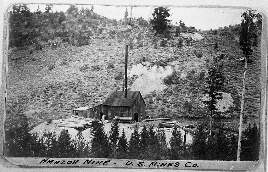
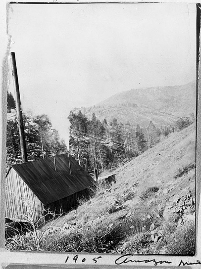


Amazon Mine, Swan Peak Mining District, Cache County, Utah, USA