| Locality | Latitude | Longitude | Distance | Bearing |
|---|
| Pednandrea Mine (Pedn-an-Drea Mine), Redruth, Cornwall, England, UK | 50° 13' 59" N | 5° 13' 21" W | 0.3km (0.2 miles) | |
| Wheal Sparnon, Redruth, Cornwall, England, UK | 50° 13' 46" N | 5° 13' 31" W | 0.4km (0.2 miles) | |
| Dopp's Mine, Pednandrea Mine (Pedn-an-Drea Mine), Redruth, Cornwall, England, UK | 50° 14' 7" N | 5° 13' 12" W | 0.5km (0.3 miles) | |
| Wheal Buggins (Wheal Buggens), Pednandrea Mine (Pedn-an-Drea Mine), Redruth, Cornwall, England, UK | 50° 14' 1" N | 5° 13' 6" W | 0.5km (0.3 miles) | |
| East Carn Brea Mine, Redruth, Cornwall, England, UK | 50° 13' 40" N | 5° 13' 50" W | 0.7km (0.4 miles) | |
| East Wheal Tolgus (Redruth Consols), Redruth, Cornwall, England, UK | 50° 14' 12" N | 5° 14' 3" W | 0.7km (0.4 miles) | |
| Buckett's Mine, Redruth, Cornwall, England, UK | 50° 13' 31" N | 5° 13' 24" W | 0.9km (0.5 miles) | |
| Wheal Union, Redruth, Cornwall, England, UK | 50° 13' 46" N | 5° 14' 17" W | 1.0km (0.6 miles) | |
| Tarewaste, Redruth, Cornwall, England, UK | 50° 14' 2" N | 5° 14' 30" W | 1.1km (0.7 miles) | |
| Wheal Grambler (East Wheal Sparnon), St Aubyn United Mines (Grambler and St Aubyn Mines), St Day, Cornwall, England, UK | 50° 13' 58" N | 5° 12' 35" W | 1.1km (0.7 miles) | |
| Wheal Breeches (Wheal Prosper), Wheal Union, Redruth, Cornwall, England, UK | 50° 13' 52" N | 5° 14' 32" W | 1.2km (0.7 miles) | |
| Wheal Trelawny, St Day, Cornwall, England, UK | 50° 13' 49" N | 5° 12' 35" W | 1.2km (0.7 miles) | |
| Wheal Trefusis (incl. East Wheal Trefusis), Redruth, Cornwall, England, UK | 50° 13' 24" N | 5° 13' 4" W | 1.2km (0.8 miles) | |
| Wheal Cupid, Redruth, Cornwall, England, UK | 50° 14' 11" N | 5° 12' 32" W | 1.3km (0.8 miles) | |
| Clyjah and Wentworth Mine (Perseverance Mine), Redruth, Cornwall, England, UK | 50° 13' 18" N | 5° 13' 19" W | 1.3km (0.8 miles) | |
| Carn Brea (village), Carn Brea, Cornwall, England, UK | 50° 13' 34" N | 5° 14' 26" W | 1.3km (0.8 miles) | |
| Treleigh Wood Mine, Redruth, Cornwall, England, UK | 50° 14' 42" N | 5° 13' 34" W | 1.3km (0.8 miles) | |
| Great South Wheal Tolgus, Tarewaste, Redruth, Cornwall, England, UK | 50° 14' 0" N | 5° 14' 42" W | 1.4km (0.8 miles) | |
| Wheal Uny, Redruth, Cornwall, England, UK | 50° 13' 17" N | 5° 13' 59" W | 1.4km (0.9 miles) | |
| Wheal St Aubyn, St Aubyn United Mines (Grambler and St Aubyn Mines), St Day, Cornwall, England, UK | 50° 14' 2" N | 5° 12' 21" W | 1.4km (0.9 miles) | |
| New Tolgus Shaft, Tarewaste, Redruth, Cornwall, England, UK | 50° 14' 5" N | 5° 14' 47" W | 1.5km (0.9 miles) | |
| St Aubyn United Mines (Grambler and St Aubyn Mines), St Day, Cornwall, England, UK | 50° 14' 9" N | 5° 12' 19" W | 1.5km (0.9 miles) | |
| Wheal Harmony (Wheal Garden), Treleigh Wood Mine, Redruth, Cornwall, England, UK | 50° 14' 48" N | 5° 13' 45" W | 1.5km (0.9 miles) | |
| Wheal Montague, Treleigh Wood Mine, Redruth, Cornwall, England, UK | 50° 14' 41" N | 5° 14' 15" W | 1.5km (1.0 miles) | |
| Tolgus Group, Redruth, Cornwall, England, UK | 50° 14' 13" N | 5° 14' 48" W | 1.5km (1.0 miles) | |
| South Wheal Tolgus, Tolgus Mount, Redruth, Cornwall, England, UK | 50° 14' 16" N | 5° 14' 50" W | 1.6km (1.0 miles) | |
| Barncoose, Carn Brea, Cornwall, England, UK | 50° 13' 49" N | 5° 14' 53" W | 1.6km (1.0 miles) | |
| Wheal Tolgus, Tolgus Mount, Redruth, Cornwall, England, UK | 50° 14' 29" N | 5° 14' 42" W | 1.6km (1.0 miles) | |
| Tolgus Mount, Redruth, Cornwall, England, UK | 50° 14' 22" N | 5° 14' 50" W | 1.7km (1.0 miles) | |
| Wheal Beauchamp, Wheal Buller and Beauchamp, Redruth, Cornwall, England, UK | 50° 13' 11" N | 5° 12' 52" W | 1.7km (1.0 miles) | |

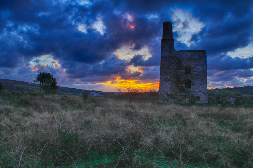
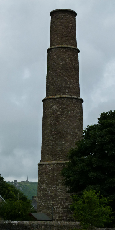


Wheal Uny, Redruth, Cornwall, England, UK