| Locality | Latitude | Longitude | Distance | Bearing |
|---|
| Hodgeholes Colliery, Richmondshire, North Yorkshire, England, UK | 54° 16' 10" N | 1° 54' 58" W | 2.0km (1.3 miles) | |
| West Scrafton Colliery, Richmondshire, North Yorkshire, England, UK | 54° 14' 1" N | 1° 53' 5" W | 3.4km (2.1 miles) | |
| Fleensop Colliery, Richmondshire, North Yorkshire, England, UK | 54° 13' 48" N | 1° 58' 2" W | 3.6km (2.3 miles) | |
| West Witton Coal Levels, Richmondshire, North Yorkshire, England, UK | 54° 17' 1" N | 1° 54' 22" W | 3.7km (2.3 miles) | |
| Scrafton Moor Colliery, Richmondshire, North Yorkshire, England, UK | 54° 13' 36" N | 1° 52' 53" W | 4.1km (2.5 miles) | |
| Spigot Lodge Pit, Richmondshire, North Yorkshire, England, UK | 54° 17' 2" N | 1° 52' 0" W | 5.2km (3.3 miles) | |
| Pike Slack Colliery, Richmondshire, North Yorkshire, England, UK | 54° 12' 14" N | 1° 55' 52" W | 5.4km (3.3 miles) | |
| Coal Shaft, Richmondshire, North Yorkshire, England, UK | 54° 12' 14" N | 1° 55' 52" W | 5.4km (3.3 miles) | |
| Wasset Fell Lead workings, Newbiggin, Richmondshire, North Yorkshire, England, UK | 54° 14' 49" N | 2° 0' 55" W | 5.8km (3.6 miles) | |
| Beldin Gill Pit, Harrogate, North Yorkshire, England, UK | 54° 12' 51" N | 1° 51' 13" W | 6.3km (3.9 miles) | |
| Long Gill Pit, Harrogate, North Yorkshire, England, UK | 54° 12' 58" N | 1° 51' 2" W | 6.3km (3.9 miles) | |
| Steam Engine Pit, Harrogate, North Yorkshire, England, UK | 54° 12' 49" N | 1° 51' 12" W | 6.4km (4.0 miles) | |
| High Engine Pit, Harrogate, North Yorkshire, England, UK | 54° 12' 51" N | 1° 51' 6" W | 6.4km (4.0 miles) | |
| Lead Pit Level, Harrogate, North Yorkshire, England, UK | 54° 12' 51" N | 1° 51' 6" W | 6.4km (4.0 miles) | |
| Siddell Pit, Harrogate, North Yorkshire, England, UK | 54° 12' 51" N | 1° 51' 3" W | 6.5km (4.0 miles) | |
| Braithwaite Coal Level, Richmondshire, North Yorkshire, England, UK | 54° 15' 44" N | 1° 49' 37" W | 6.6km (4.1 miles) | |
| Bog Pit, Harrogate, North Yorkshire, England, UK | 54° 12' 51" N | 1° 50' 55" W | 6.6km (4.1 miles) | |
| Boggy Pit Grove Colliery, Harrogate, North Yorkshire, England, UK | 54° 12' 51" N | 1° 50' 48" W | 6.7km (4.1 miles) | |
| Smithy Pit, Harrogate, North Yorkshire, England, UK | 54° 12' 52" N | 1° 50' 45" W | 6.7km (4.2 miles) | |
| Butt Pit, Harrogate, North Yorkshire, England, UK | 54° 12' 53" N | 1° 50' 38" W | 6.8km (4.2 miles) | |
| Long Level, Harrogate, North Yorkshire, England, UK | 54° 12' 53" N | 1° 50' 33" W | 6.8km (4.2 miles) | |
| New House Grove Colliery, Harrogate, North Yorkshire, England, UK | 54° 12' 53" N | 1° 50' 31" W | 6.9km (4.3 miles) | |
| Ned Grove Colliery, Harrogate, North Yorkshire, England, UK | 54° 12' 54" N | 1° 50' 24" W | 7.0km (4.3 miles) | |
| Woogill Colliery, Harrogate, North Yorkshire, England, UK | 54° 11' 48" N | 1° 52' 32" W | 7.0km (4.3 miles) | |
| North Moor Coal Shaft, Harrogate, North Yorkshire, England, UK | 54° 11' 48" N | 1° 52' 30" W | 7.0km (4.3 miles) | |
| Gin Pit, Harrogate, North Yorkshire, England, UK | 54° 13' 7" N | 1° 50' 5" W | 7.0km (4.4 miles) | |
| Speedwell Pit, Harrogate, North Yorkshire, England, UK | 54° 13' 5" N | 1° 50' 6" W | 7.0km (4.4 miles) | |
| Coal Shaft, Harrogate, North Yorkshire, England, UK | 54° 11' 52" N | 1° 52' 15" W | 7.0km (4.4 miles) | |
| Seata Mine, Aysgarth, Richmondshire, North Yorkshire, England, UK | 54° 17' 31" N | 2° 0' 38" W | 7.0km (4.4 miles) | |
| Dawson Grove Colliery, Harrogate, North Yorkshire, England, UK | 54° 12' 54" N | 1° 50' 18" W | 7.0km (4.4 miles) | |


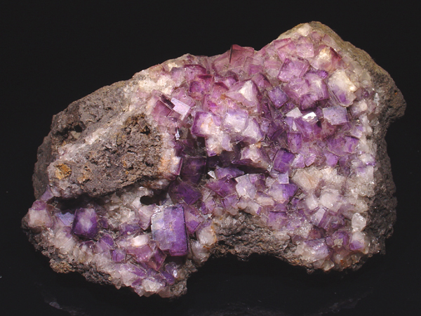

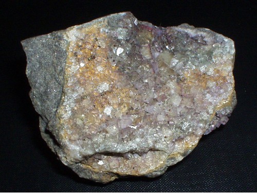


Seata Mine, Aysgarth, Richmondshire, North Yorkshire, England, UK