| Locality | Latitude | Longitude | Distance | Bearing |
|---|
| Rietfontein Consolidated Mine, Germiston, City of Ekurhuleni Metropolitan Municipality, Gauteng, South Africa | 26° 9' 13" S | 28° 11' 24" E | 3.2km (2.0 miles) | |
| Witwatersrand Gold Mine, Germiston, City of Ekurhuleni Metropolitan Municipality, Gauteng, South Africa | 26° 11' 27" S | 28° 11' 41" E | 7.0km (4.4 miles) | |
| Rose Deep Gold Mine, Germiston, City of Ekurhuleni Metropolitan Municipality, Gauteng, South Africa | 26° 11' 46" S | 28° 9' 37" E | 7.1km (4.4 miles) | |
| Glencairn Gold Mine, Germiston, City of Ekurhuleni Metropolitan Municipality, Gauteng, South Africa | 26° 11' 48" S | 28° 10' 18" E | 7.2km (4.5 miles) | |
| May Consolidated Gold Mine, Germiston, City of Ekurhuleni Metropolitan Municipality, Gauteng, South Africa | 26° 11' 53" S | 28° 9' 49" E | 7.3km (4.6 miles) | |
| Knights Deep Gold Mine, Germiston, City of Ekurhuleni Metropolitan Municipality, Gauteng, South Africa | 26° 11' 50" S | 28° 11' 8" E | 7.4km (4.6 miles) | |
| Wit Deep Gold Mine, Germiston, City of Ekurhuleni Metropolitan Municipality, Gauteng, South Africa | 26° 11' 50" S | 28° 11' 38" E | 7.7km (4.8 miles) | |
| New Primrose Gold Mine, Germiston, City of Ekurhuleni Metropolitan Municipality, Gauteng, South Africa | 26° 12' 6" S | 28° 9' 19" E | 7.8km (4.9 miles) | |
| Knights Gold Mine, Germiston, City of Ekurhuleni Metropolitan Municipality, Gauteng, South Africa | 26° 12' 4" S | 28° 11' 21" E | 7.9km (4.9 miles) | |
| Ginsberg Gold Mine, Boksburg, City of Ekurhuleni Metropolitan Municipality, Gauteng, South Africa | 26° 11' 51" S | 28° 12' 23" E | 8.2km (5.1 miles) | |
| Glen Deep Gold Mine, Germiston, City of Ekurhuleni Metropolitan Municipality, Gauteng, South Africa | 26° 12' 19" S | 28° 10' 44" E | 8.2km (5.1 miles) | |
| Simmer East Gold Mine, Germiston, City of Ekurhuleni Metropolitan Municipality, Gauteng, South Africa | 26° 12' 23" S | 28° 10' 21" E | 8.3km (5.1 miles) | |
| Geldenhuis Estate Gold Mine, Germiston, City of Ekurhuleni Metropolitan Municipality, Gauteng, South Africa | 26° 12' 13" S | 28° 8' 31" E | 8.4km (5.2 miles) | |
| Knight Central Gold Mine, Germiston, City of Ekurhuleni Metropolitan Municipality, Gauteng, South Africa | 26° 12' 21" S | 28° 11' 11" E | 8.4km (5.2 miles) | |
| Stanhope Gold Mine, Germiston, City of Ekurhuleni Metropolitan Municipality, Gauteng, South Africa | 26° 12' 12" S | 28° 8' 17" E | 8.5km (5.3 miles) | |
| East Rand Proprietary Mine (ERPM Mine), City of Ekurhuleni Metropolitan Municipality, Gauteng, South Africa | 26° 11' 54" S | 28° 12' 44" E | 8.6km (5.3 miles) | |
| Driefontein Gold Mine, Boksburg, City of Ekurhuleni Metropolitan Municipality, Gauteng, South Africa | 26° 11' 55" S | 28° 12' 46" E | 8.6km (5.4 miles) | |
| Witwatersrand gold mine, Boksburg, City of Ekurhuleni Metropolitan Municipality, Gauteng, South Africa | 26° 12' 12" S | 28° 12' 21" E | 8.7km (5.4 miles) | |
| South Rose Deep Gold Mine, Germiston, City of Ekurhuleni Metropolitan Municipality, Gauteng, South Africa | 26° 12' 39" S | 28° 9' 31" E | 8.8km (5.5 miles) | |
| Simmer & Jack Gold Mine, Germiston, City of Ekurhuleni Metropolitan Municipality, Gauteng, South Africa | 26° 12' 37" S | 28° 8' 44" E | 9.0km (5.6 miles) | |
| Phoenix Syndicate Gold Mine, Boksburg, City of Ekurhuleni Metropolitan Municipality, Gauteng, South Africa | 26° 12' 26" S | 28° 12' 23" E | 9.2km (5.7 miles) | |
| Geldenhuis Deep Gold Mine, Germiston, City of Ekurhuleni Metropolitan Municipality, Gauteng, South Africa | 26° 12' 45" S | 28° 8' 20" E | 9.4km (5.8 miles) | |
| Angelo Gold Mine, Boksburg, City of Ekurhuleni Metropolitan Municipality, Gauteng, South Africa | 26° 12' 6" S | 28° 13' 21" E | 9.4km (5.9 miles) | |
| Driefontein Consolidated Mine, Boksburg, City of Ekurhuleni Metropolitan Municipality, Gauteng, South Africa | 26° 12' 25" S | 28° 13' 7" E | 9.7km (6.0 miles) | |
| Jumpers Gold Mine, City of Johannesburg Metropolitan Municipality, Gauteng, South Africa | 26° 12' 35" S | 28° 7' 13" E | 9.9km (6.1 miles) | |
| New Comet Gold Mine, Boksburg, City of Ekurhuleni Metropolitan Municipality, Gauteng, South Africa | 26° 12' 15" S | 28° 13' 52" E | 10.2km (6.3 miles) | |
| New Heriot Gold Mine, Johannesburg, City of Johannesburg Metropolitan Municipality, Gauteng, South Africa | 26° 12' 43" S | 28° 7' 4" E | 10.2km (6.3 miles) | |
| Jumpers Deep Gold Mine, City of Johannesburg Metropolitan Municipality, Gauteng, South Africa | 26° 12' 46" S | 28° 7' 0" E | 10.3km (6.4 miles) | |
| Germiston, City of Ekurhuleni Metropolitan Municipality, Gauteng, South Africa | 26° 13' 45" S | 28° 10' 51" E | 10.9km (6.8 miles) | |
| East Rand Gold Mine, Boksburg, City of Ekurhuleni Metropolitan Municipality, Gauteng, South Africa | 26° 12' 52" S | 28° 13' 54" E | 11.1km (6.9 miles) | |

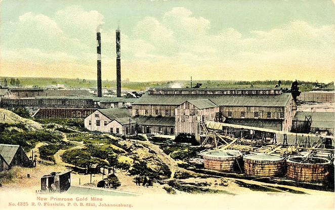


New Primrose Gold Mine, Germiston, City of Ekurhuleni Metropolitan Municipality, Gauteng, South Africa