| Locality | Latitude | Longitude | Distance | Bearing |
|---|
| Sylling, Lier, Buskerud, Norway | 59° 53' 34" N | 10° 17' 28" E | 0.8km (0.5 miles) | |
| Hørtekollen Fluorite Mine, Sylling, Lier, Buskerud, Norway | 59° 54' 33" N | 10° 16' 27" E | 1.3km (0.8 miles) | |
| Asdøljuvet (Astøljuvet), Lier, Buskerud, Norway | 59° 52' 24" N | 10° 18' 29" E | 3.1km (2.0 miles) | |
| Asdøl, Lier, Buskerud, Norway | 59° 52' 16" N | 10° 19' 25" E | 3.8km (2.4 miles) | |
| Bø Mine, Lierskogen, Lier, Buskerud, Norway | 59° 50' 41" N | 10° 20' 13" E | 6.7km (4.2 miles) | |
| Mobråtan, Asker, Viken, Norway | 59° 51' 58" N | 10° 24' 24" E | 7.8km (4.8 miles) | |
| Slettfjella, Lier, Buskerud, Norway | 59° 53' 0" N | 10° 8' 43" E | 7.9km (4.9 miles) | |
| Sollihøgda, Hole, Buskerud, Norway | 59° 57' 49" N | 10° 20' 43" E | 8.0km (5.0 miles) | |
| Olledalen Shooting Range (Bergsmarka), Asker, Viken, Norway | 59° 50' 42" N | 10° 22' 45" E | 8.0km (5.0 miles) | |
| Kattås, Sandvika, Bærum (Baerum), Viken, Norway | 59° 53' 39" N | 10° 25' 39" E | 8.1km (5.0 miles) | |
| Øksne Quarry, Lier, Buskerud, Norway | 59° 49' 59" N | 10° 12' 30" E | 8.4km (5.2 miles) | |
| Hajum waterfall, Asker, Viken, Norway | 59° 51' 41" N | 10° 25' 4" E | 8.6km (5.3 miles) | |
| Lierskogen Quarry, Lierskogen, Lier, Buskerud, Norway | 59° 49' 6" N | 10° 17' 49" E | 9.0km (5.6 miles) | |
| Skaret, Sollihøgda, Hole, Buskerud, Norway | 59° 58' 36" N | 10° 19' 35" E | 9.0km (5.6 miles) | |
| Buttedal Mine, Tranby, Lier, Buskerud, Norway | 59° 49' 7" N | 10° 15' 42" E | 9.0km (5.6 miles) | |
| Ringeriksveien Prospect, Bærum (Baerum), Viken, Norway | 59° 56' 4" N | 10° 25' 53" E | 9.2km (5.7 miles) | |
| Lierskogen, Lier, Buskerud, Norway | 59° 49' 10" N | 10° 19' 50" E | 9.2km (5.7 miles) | |
| Skaret Tunnel E 16, Sollihøgda, Hole, Buskerud, Norway | 59° 58' 48" N | 10° 19' 1" E | 9.2km (5.7 miles) | |
| Sølvhølen Prospect, Bærum (Baerum), Viken, Norway | 59° 55' 53" N | 10° 26' 7" E | 9.2km (5.7 miles) | |
| Humledal, Hole, Buskerud, Norway | 59° 58' 51" N | 10° 18' 42" E | 9.3km (5.8 miles) | |
| Gjellebekk marble quarry, Gjellebekk, Lier, Buskerud, Norway | 59° 48' 43" N | 10° 17' 0" E | 9.6km (6.0 miles) | |
| Markebekk Prospect 1, Bærum (Baerum), Viken, Norway | 59° 56' 27" N | 10° 26' 6" E | 9.7km (6.0 miles) | |
| Gjellebekk Mine (Auvi Mine), Gjellebekk, Lier, Buskerud, Norway | 59° 48' 39" N | 10° 17' 44" E | 9.8km (6.1 miles) | |
| Kjenner Bismuth Mine, Lierskogen, Lier, Buskerud, Norway | 59° 48' 41" N | 10° 19' 1" E | 9.9km (6.2 miles) | |
| Tranby, Lier, Buskerud, Norway | 59° 48' 37" N | 10° 15' 38" E | 9.9km (6.2 miles) | |
| Gjellebekk, Lier, Buskerud, Norway | 59° 48' 32" N | 10° 17' 54" E | 10.0km (6.2 miles) | |
| Isi Prospect, Bærum (Baerum), Viken, Norway | 59° 56' 28" N | 10° 26' 36" E | 10.1km (6.3 miles) | |
| Liertoppen, Lier, Buskerud, Norway | 59° 48' 28" N | 10° 17' 37" E | 10.1km (6.3 miles) | |
| Eggekollen, Lier, Buskerud, Norway | 59° 49' 33" N | 10° 10' 23" E | 10.2km (6.3 miles) | |
| Oppsjøen Mine, Oppsjø, Dikemark, Asker, Viken, Norway | 59° 48' 51" N | 10° 22' 52" E | 10.9km (6.8 miles) | |
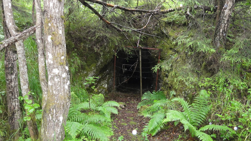


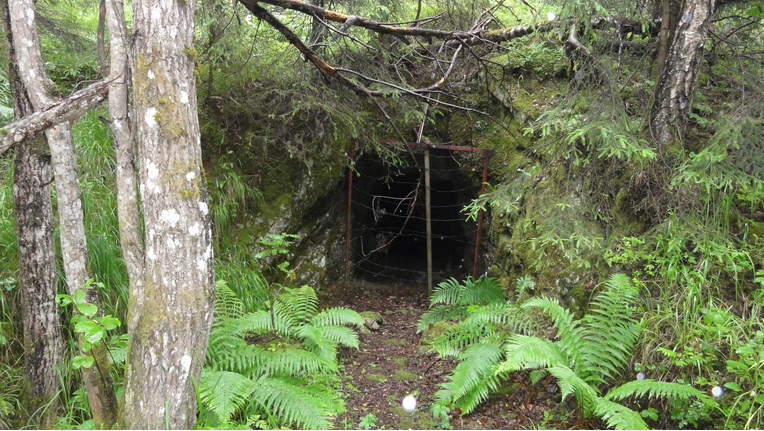


Gjellebekk Mine, Gjellebekk, Lier, Buskerud, Norway