| Locality | Latitude | Longitude | Distance | Bearing |
|---|
| Essoskogen, Slagen, Tønsberg, Vestfold, Norway | 59° 18' 34" N | 10° 31' 35" E | 8.1km (5.1 miles) | |
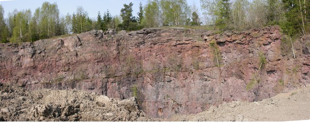
| Haraldstad Quarry, Slagen, Tønsberg, Vestfold, Norway | 59° 19' 18" N | 10° 29' 36" E | 9.7km (6.1 miles) | |
| Saltkopp, Tønsberg, Vestfold, Norway | 59° 20' 0" N | 10° 29' 23" E | 9.9km (6.2 miles) | |
| Moss Meteorite, Moss, Viken, Norway | 59° 25' 59" N | 10° 41' 59" E | 11.8km (7.3 miles) | |
| Karlshus Mine, Råde, Østfold, Norway | 59° 21' 36" N | 10° 51' 55" E | 11.9km (7.4 miles) | |
| Hattvik Feldspar Quarry, Dillingøya (Dillingö), Moss, Viken, Norway | 59° 25' 42" N | 10° 45' 47" E | 12.4km (7.7 miles) | |
| Ånnerud (Ånnerød), Våler, Østfold, Norway | 59° 25' 32" N | 10° 46' 43" E | 12.6km (7.8 miles) | |
| Halvorsrød, Råde, Østfold, Norway | 59° 21' 56" N | 10° 52' 37" E | 12.7km (7.9 miles) | |
| Gullholmen Copper Occurrence, Moss, Viken, Norway | 59° 26' 7" N | 10° 34' 54" E | 12.8km (7.9 miles) | |
| Onsøy quarry, Fredrikstad, Østfold, Norway | 59° 14' 42" N | 10° 49' 55" E | 13.3km (8.3 miles) | |
| Moss Quarry (Skolt Quarry), Moss, Viken, Norway | 59° 26' 56" N | 10° 43' 46" E | 13.9km (8.6 miles) | |
| Skoppum, Horten, Vestfold, Norway | 59° 23' 0" N | 10° 25' 25" E | 14.9km (9.3 miles) | |
| Eik, Tønsberg, Vestfold, Norway | 59° 17' 3" N | 10° 24' 45" E | 15.1km (9.4 miles) | |
| Skoppum Quarry, Skoppum, Horten, Vestfold, Norway | 59° 22' 41" N | 10° 24' 55" E | 15.2km (9.4 miles) | |
| Tomsbakken, Tønsberg, Vestfold, Norway | 59° 17' 35" N | 10° 24' 20" E | 15.2km (9.5 miles) | |
| Frodeåsen Tunnel, Tønsberg, Vestfold, Norway | 59° 16' 54" N | 10° 24' 18" E | 15.6km (9.7 miles) | |
| Near Simrad, Horten, Vestfold, Norway | 59° 25' 35" N | 10° 27' 55" E | 15.7km (9.7 miles) | |
| Tokerødveien (Roadcut RV 306), Skoppum, Horten, Vestfold, Norway | 59° 22' 41" N | 10° 24' 10" E | 15.8km (9.8 miles) | |
| Skoppum Industrial site, Skoppum, Horten, Vestfold, Norway | 59° 22' 41" N | 10° 23' 51" E | 16.1km (10.0 miles) | |
| Innlaget, Skoppum, Horten, Vestfold, Norway | 59° 22' 42" N | 10° 23' 34" E | 16.4km (10.2 miles) | |
| Bekkajordet, Borre, Horten, Vestfold, Norway | 59° 25' 56" N | 10° 27' 9" E | 16.7km (10.3 miles) | |
| Råde quarry, Slangsvoll, Råde, Østfold, Norway | 59° 21' 25" N | 10° 57' 11" E | 16.7km (10.4 miles) | |
| Solerød, Undrumsdal, Tønsberg, Vestfold, Norway | 59° 22' 3" N | 10° 22' 50" E | 16.7km (10.4 miles) | |
| Kambo Iron Mine, Moss, Viken, Norway | 59° 28' 56" N | 10° 42' 7" E | 17.2km (10.7 miles) | |
| Undrumsdal, Tønsberg, Vestfold, Norway | 59° 22' 17" N | 10° 22' 14" E | 17.3km (10.8 miles) | |
| Steinbjørnrød Tunnel-Undrumsdal Crossing, Undrumsdal, Tønsberg, Vestfold, Norway | 59° 22' 47" N | 10° 22' 29" E | 17.4km (10.8 miles) | |
| Skavli, Borre, Horten, Vestfold, Norway | 59° 26' 16" N | 10° 26' 32" E | 17.5km (10.9 miles) | |
| E 18 Flår, Tønsberg, Vestfold, Norway | 59° 23' 20" N | 10° 22' 25" E | 17.8km (11.1 miles) | |
| Veggefjell, Falkensten, Borre, Horten, Vestfold, Norway | 59° 26' 2" N | 10° 25' 30" E | 17.9km (11.1 miles) | |
| Flår tunnel, E 18 Flår, Tønsberg, Vestfold, Norway | 59° 23' 32" N | 10° 22' 19" E | 18.0km (11.2 miles) | |
Minerals recorded nearby (within 18.0 km)
Rock types recorded nearby (within 18.0 km)
Entries shown in red are rocks recorded for this region.


Haraldstad Quarry, Slagen, Tønsberg, Vestfold, Norway