Home PageAbout MindatThe Mindat ManualHistory of MindatCopyright StatusWho We AreContact UsAdvertise on Mindat
Donate to MindatCorporate SponsorshipSponsor a PageSponsored PagesMindat AdvertisersAdvertise on Mindat
Learning CenterWhat is a mineral?The most common minerals on earthInformation for EducatorsMindat ArticlesThe ElementsThe Rock H. Currier Digital LibraryGeologic Time
Minerals by PropertiesMinerals by ChemistryAdvanced Locality SearchRandom MineralRandom LocalitySearch by minIDLocalities Near MeSearch ArticlesSearch GlossaryMore Search Options
The Mindat ManualAdd a New PhotoRate PhotosLocality Edit ReportCoordinate Completion ReportAdd Glossary Item
Mining CompaniesStatisticsUsersMineral MuseumsClubs & OrganizationsMineral Shows & EventsThe Mindat DirectoryDevice SettingsThe Mineral Quiz
Photo SearchPhoto GalleriesSearch by ColorNew Photos TodayNew Photos YesterdayMembers' Photo GalleriesPast Photo of the Day GalleryPhotography
╳Discussions
💬 Home🔎 Search📅 LatestGroups
EducationOpen discussion area.Fakes & FraudsOpen discussion area.Field CollectingOpen discussion area.FossilsOpen discussion area.Gems and GemologyOpen discussion area.GeneralOpen discussion area.How to ContributeOpen discussion area.Identity HelpOpen discussion area.Improving Mindat.orgOpen discussion area.LocalitiesOpen discussion area.Lost and Stolen SpecimensOpen discussion area.MarketplaceOpen discussion area.MeteoritesOpen discussion area.Mindat ProductsOpen discussion area.Mineral ExchangesOpen discussion area.Mineral PhotographyOpen discussion area.Mineral ShowsOpen discussion area.Mineralogical ClassificationOpen discussion area.Mineralogy CourseOpen discussion area.MineralsOpen discussion area.Minerals and MuseumsOpen discussion area.PhotosOpen discussion area.Techniques for CollectorsOpen discussion area.The Rock H. Currier Digital LibraryOpen discussion area.UV MineralsOpen discussion area.Recent Images in Discussions


General(Meta)torbernite: which species to add to locality?

11th Apr 2018 17:18 UTCEd Clopton 🌟 Expert
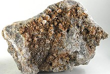
The question is this: Which species should I add to the locality page? Pieces lying around on the surface there most likely have dehydrated, so metatorbernite could be said to occur there. But can we assume that material still in situ (i.e., not yet exposed to the atmosphere) formed as, and probably still is, torbernite? Or might it have formed originally as metatorbernite? Does the presence of (presumed) metatorbernite necessarily indicate that torbernite exists (or existed) there as well?
Bottom line, should I add both to the species list and upload my photos under metatorbernite?

11th Apr 2018 17:40 UTCUwe Kolitsch Manager
> It is assumed that torbernite dehydrates to metatorbernite under surface conditions
Not always - depends on conditions.
11th Apr 2018 19:28 UTCRichard Gunter Expert

11th Apr 2018 22:27 UTCReiner Mielke Expert
11th Apr 2018 23:36 UTCRichard Gunter Expert
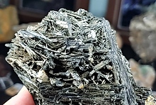
I think this sample was one that John Degenais collected underground so the differences would have come from air circulation.
12th Apr 2018 11:19 UTCUwe Kolitsch Manager
"Air circulation" basically means you may have slightly different humidities and temperatures.
12th Apr 2018 14:35 UTCEd Clopton 🌟 Expert
12th Apr 2018 15:25 UTCUwe Kolitsch Manager


Mindat.org is an outreach project of the Hudson Institute of Mineralogy, a 501(c)(3) not-for-profit organization.
Copyright © mindat.org and the Hudson Institute of Mineralogy 1993-2024, except where stated. Most political location boundaries are © OpenStreetMap contributors. Mindat.org relies on the contributions of thousands of members and supporters. Founded in 2000 by Jolyon Ralph.
Privacy Policy - Terms & Conditions - Contact Us / DMCA issues - Report a bug/vulnerability Current server date and time: April 16, 2024 11:07:13