Glengormley, Co. Antrim, Northern Ireland, UKi
| Regional Level Types | |
|---|---|
| Glengormley | Township |
| Co. Antrim | County |
| Northern Ireland | Constituent Country |
| UK | Country |
This page is currently not sponsored. Click here to sponsor this page.


Latitude & Longitude (WGS84):
54° 40' 16'' North , 5° 57' 30'' West
Latitude & Longitude (decimal):
Type:
Köppen climate type:
Mindat Locality ID:
146623
Long-form identifier:
mindat:1:2:146623:5
GUID (UUID V4):
1ae6a065-7ca7-40a2-941f-d1c02b0edc36
Glengormley (from Irish: Gleann Ghormlaithe, meaning 'Gormlaith's valley') is a townland (of 215 acres) and electoral ward in County Antrim, Northern Ireland. Glengormley is within the urban area of Newtownabbey and the Antrim and Newtownabbey Borough Council area, though is effectively a suburb of Belfast. It is also situated in the civil parish of Carnmoney and the historic barony of Belfast Lower.
The original settlement grew up in the mid-19th century, around a junction of the roads linking Belfast with Antrim and Ballyclare.
The wider suburban area of Glengormley borders North Belfast, Carnmoney and Mallusk. It is a popular residential area that includes developments in 1995–2005 which have seen an expansion upwards from the village to the Hightown Road.
Glengormley is approximately six miles from Belfast; the sixth milestone from the city centre is located on the Ballyclare Road beside Glengormley High School.
As the lowest pass through the Belfast hills from the northern prospect, Glengormley is also traversed by major communication arteries, including the Belfast to Derry railway line (served by Mossley West halt) and the M2 motorway.
Despite being technically a glen (the area is in the valley between Cave Hill and Carnmoney Hill), Glengormley sits at 700 feet (ca. 213 m) above sea level, and has a climate noticeably colder than the adjacent Lagan valley area. The cold and windy weather may be explained by the 'tunnel' of natural features running from the Antrim coast to the edge of Glengormley on the Hightown Road. The 'tunnel' can be seen from the Cavehill Country Park entrance at Hightown Road, looking north towards Slemish.
Select Mineral List Type
Standard Detailed Gallery Strunz Chemical ElementsDetailed Mineral List:
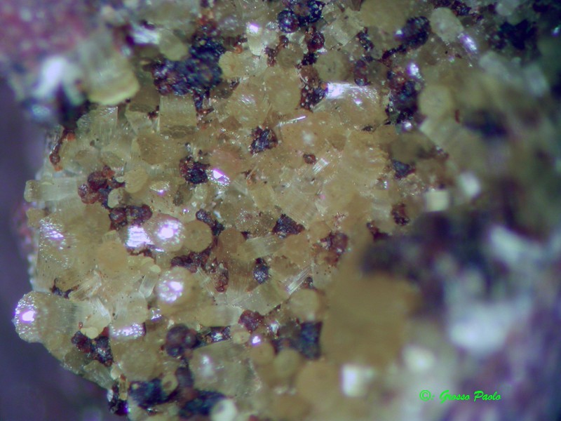
| ⓘ Erionite-Ca Formula: (Ca,K2,Na2)2[Al4Si14O36] · 15H2O References: |
Gallery:

List of minerals arranged by Strunz 10th Edition classification
| Group 9 - Silicates | |||
|---|---|---|---|
| ⓘ | Erionite-Ca | 9.GD.20 | (Ca,K2,Na2)2[Al4Si14O36] · 15H2O |
List of minerals for each chemical element
| H | Hydrogen | |
|---|---|---|
| H | ⓘ Erionite-Ca | (Ca,K2,Na2)2[Al4Si14O36] · 15H2O |
| O | Oxygen | |
| O | ⓘ Erionite-Ca | (Ca,K2,Na2)2[Al4Si14O36] · 15H2O |
| Na | Sodium | |
| Na | ⓘ Erionite-Ca | (Ca,K2,Na2)2[Al4Si14O36] · 15H2O |
| Al | Aluminium | |
| Al | ⓘ Erionite-Ca | (Ca,K2,Na2)2[Al4Si14O36] · 15H2O |
| Si | Silicon | |
| Si | ⓘ Erionite-Ca | (Ca,K2,Na2)2[Al4Si14O36] · 15H2O |
| K | Potassium | |
| K | ⓘ Erionite-Ca | (Ca,K2,Na2)2[Al4Si14O36] · 15H2O |
| Ca | Calcium | |
| Ca | ⓘ Erionite-Ca | (Ca,K2,Na2)2[Al4Si14O36] · 15H2O |
Other Databases
| Wikipedia: | https://en.wikipedia.org/wiki/Glengormley |
|---|---|
| Wikidata ID: | Q1375396 |
Other Regions, Features and Areas containing this locality
British and Irish IslesGroup of Islands
Eurasian PlateTectonic Plate
EuropeContinent
Ireland (island)Island
North Atlantic Igneous ProvinceLarge Igneous Province
This page contains all mineral locality references listed on mindat.org. This does not claim to be a complete list. If you know of more minerals from this site, please register so you can add to our database. This locality information is for reference purposes only. You should never attempt to
visit any sites listed in mindat.org without first ensuring that you have the permission of the land and/or mineral rights holders
for access and that you are aware of all safety precautions necessary.


Glengormley, Co. Antrim, Northern Ireland, UK