Rosiclare Mining Sub-District, Hardin County, Illinois, USAi
| Regional Level Types | |
|---|---|
| Rosiclare Mining Sub-District | Mining District |
| Hardin County | County |
| Illinois | State |
| USA | Country |
This page is currently not sponsored. Click here to sponsor this page.


Type:
Largest Settlements:
| Place | Population |
|---|---|
| Rosiclare | 1,082 (2017) |
Mindat Locality ID:
9023
Long-form identifier:
mindat:1:2:9023:3
GUID (UUID V4):
cb8a20d8-56aa-436f-9ec7-f1673bd1fd21
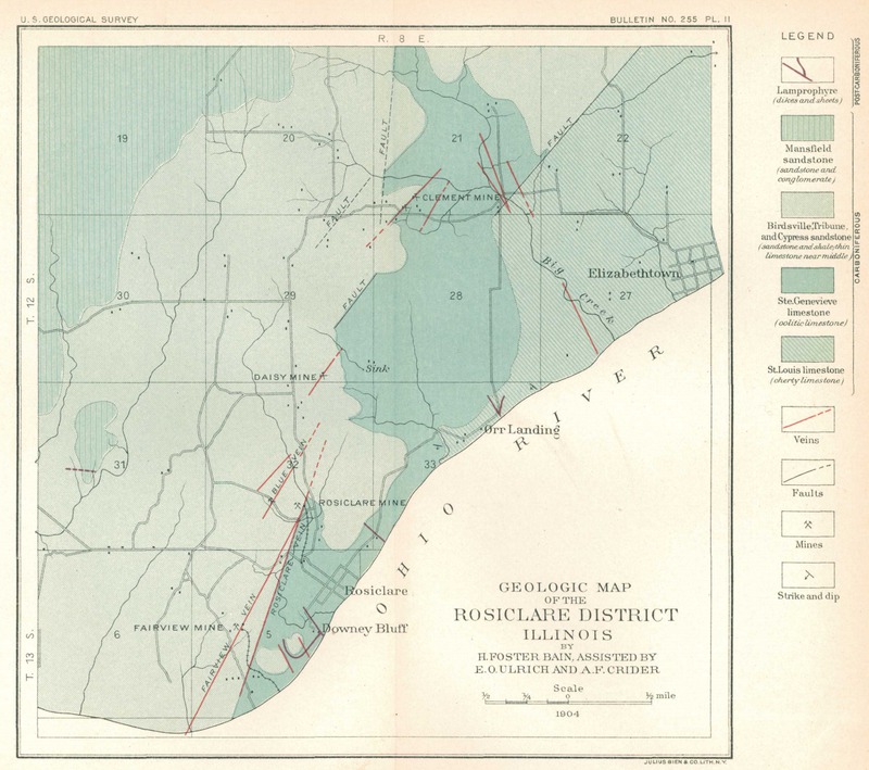
The Rosiclare fluorspar subdistrict is located in southwestern Hardin County and southeastern Pope County. It extends from the Ohio River W of the town of Rosiclare, NNE for nearly four miles to Big Creek.
Localities within Pope County in proximity to the city of Rosiclare (Hardin County), in the Rosiclare District. The Pope County segment of the district is absent any populated places in this area.
The Rosiclare Subdistrict is located in Hardin County, in southeastern Illinois, and extends from the Ohio River northward through the village of Rosiclare to just north of Illinois Route 146. The Rosiclare Mine, which operated for more than a century, was at one time the largest fluorspar mine in the United States and possibly the world. Several adjacent mines, notably the Argo, Blue Diggings, Daisy, Eureka, and Hillside, were also major producers. The veins are aligned along a set of north-trending normal faults of slight to moderate displacement. Mineralization is predominantly fluorite, along with calcite and lesser amounts of quartz, galena, and sphalerite. Barite in the Rosiclare Subdistrict is not common, in contrast to some other parts of the IKFD. The widest veins in the Rosiclare Subdistrict typically lay where one or both walls of the fault were composed of limestone or highly calcareous units. Fluorspar also replaced an earlier-phase calcite already present within the faults and fractures. Both the fault and vein were usually named the same; thus, the Rosiclare Vein lay along the Rosiclare Fault. From east to west, the major veins are named the Hillside, Rosiclare, Daisy, Blue Diggings, Argo, and Knight. The biggest problem in the Rosiclare Subdistrict was flooding, which forced a number of mines (including the Rosiclare) to shut down temporarily or permanently. In mines at the southern end of this subdistrict, fissures may have channeled water directly from the Ohio River into underground workings.
Select Mineral List Type
Standard Detailed Gallery Strunz Chemical ElementsCommodity List
This is a list of exploitable or exploited mineral commodities recorded from this region.Mineral List
Mineral list contains entries from the region specified including sub-localities19 valid minerals.
Rock Types Recorded
Note: data is currently VERY limited. Please bear with us while we work towards adding this information!
Rock list contains entries from the region specified including sub-localities
Select Rock List Type
Alphabetical List Tree DiagramDetailed Mineral List:
| ⓘ Baryte Formula: BaSO4 Localities: Reported from at least 7 localities in this region. |
| ⓘ Calcite Formula: CaCO3 Localities: Reported from at least 16 localities in this region. |
| ⓘ Cerussite Formula: PbCO3 Locality: Rosiclare, Hardin County, Illinois, USA |
| ⓘ Chalcopyrite Formula: CuFeS2 Localities: References: |
| ⓘ Copper Formula: Cu |
| ⓘ Fluorite Formula: CaF2 Localities: Reported from at least 19 localities in this region. |
| ⓘ Galena Formula: PbS Localities: Reported from at least 13 localities in this region. |
| ⓘ Greenockite Formula: CdS Localities: References: |
| ⓘ Gypsum Formula: CaSO4 · 2H2O Localities: |
| ⓘ Jamesonite Formula: Pb4FeSb6S14 |
| ⓘ 'Limonite' |
| ⓘ Malachite Formula: Cu2(CO3)(OH)2 Localities: References: |
| ⓘ 'Petroleum var. Bitumen' |
| ⓘ Pyrite Formula: FeS2 Localities: Reported from at least 6 localities in this region. |
| ⓘ Pyromorphite Formula: Pb5(PO4)3Cl Locality: Rosiclare, Hardin County, Illinois, USA |
| ⓘ Quartz Formula: SiO2 Localities: Reported from at least 7 localities in this region. References: |
| ⓘ Smithsonite Formula: ZnCO3 |
| ⓘ Sphalerite Formula: ZnS Localities: Reported from at least 11 localities in this region. |
| ⓘ Stibnite Formula: Sb2S3 |
| ⓘ Strontianite Formula: SrCO3 References: |
| ⓘ Witherite Formula: BaCO3 Localities: References: |
Gallery:

List of minerals arranged by Strunz 10th Edition classification
| Group 1 - Elements | |||
|---|---|---|---|
| ⓘ | Copper | 1.AA.05 | Cu |
| Group 2 - Sulphides and Sulfosalts | |||
| ⓘ | Sphalerite | 2.CB.05a | ZnS |
| ⓘ | Chalcopyrite | 2.CB.10a | CuFeS2 |
| ⓘ | Greenockite | 2.CB.45 | CdS |
| ⓘ | Galena | 2.CD.10 | PbS |
| ⓘ | Stibnite | 2.DB.05 | Sb2S3 |
| ⓘ | Pyrite | 2.EB.05a | FeS2 |
| ⓘ | Jamesonite | 2.HB.15 | Pb4FeSb6S14 |
| Group 3 - Halides | |||
| ⓘ | Fluorite | 3.AB.25 | CaF2 |
| Group 4 - Oxides and Hydroxides | |||
| ⓘ | Quartz | 4.DA.05 | SiO2 |
| Group 5 - Nitrates and Carbonates | |||
| ⓘ | Smithsonite | 5.AB.05 | ZnCO3 |
| ⓘ | Calcite | 5.AB.05 | CaCO3 |
| ⓘ | Strontianite | 5.AB.15 | SrCO3 |
| ⓘ | Witherite | 5.AB.15 | BaCO3 |
| ⓘ | Cerussite | 5.AB.15 | PbCO3 |
| ⓘ | Malachite | 5.BA.10 | Cu2(CO3)(OH)2 |
| Group 7 - Sulphates, Chromates, Molybdates and Tungstates | |||
| ⓘ | Baryte | 7.AD.35 | BaSO4 |
| ⓘ | Gypsum | 7.CD.40 | CaSO4 · 2H2O |
| Group 8 - Phosphates, Arsenates and Vanadates | |||
| ⓘ | Pyromorphite | 8.BN.05 | Pb5(PO4)3Cl |
| Unclassified | |||
| ⓘ | 'Limonite' | - | |
| ⓘ | 'Petroleum var. Bitumen' | - | |
List of minerals for each chemical element
Fossils
This region is too big or complex to display the fossil list, try looking at smaller subregions.Localities in this Region
Other Regions, Features and Areas that Intersect
North America PlateTectonic Plate
- Illinois BasinBasin
- Shawnee DomainDomain
USA
- Illinois-Kentucky Fluorspar DistrictMining District
- Rough Creek GrabenBasin
This page contains all mineral locality references listed on mindat.org. This does not claim to be a complete list. If you know of more minerals from this site, please register so you can add to our database. This locality information is for reference purposes only. You should never attempt to
visit any sites listed in mindat.org without first ensuring that you have the permission of the land and/or mineral rights holders
for access and that you are aware of all safety precautions necessary.
References


Rosiclare Mining Sub-District, Hardin County, Illinois, USA