Spring Hill Gold Mine (Carlyle), Parker Range Goldfield, Yilgarn Shire, Western Australia, Australia

| Latitude & Longitude (WGS84): | 31° 39' 26'' South , 119° 34' 39'' East |
|---|---|
| Latitude & Longitude (decimal): | -31.65749,119.57758 |
| GeoHash: | G#: qdm5chctz |
| Locality type: | Mine |
| Köppen climate type: | BSk : Cold semi-arid (steppe) climate |
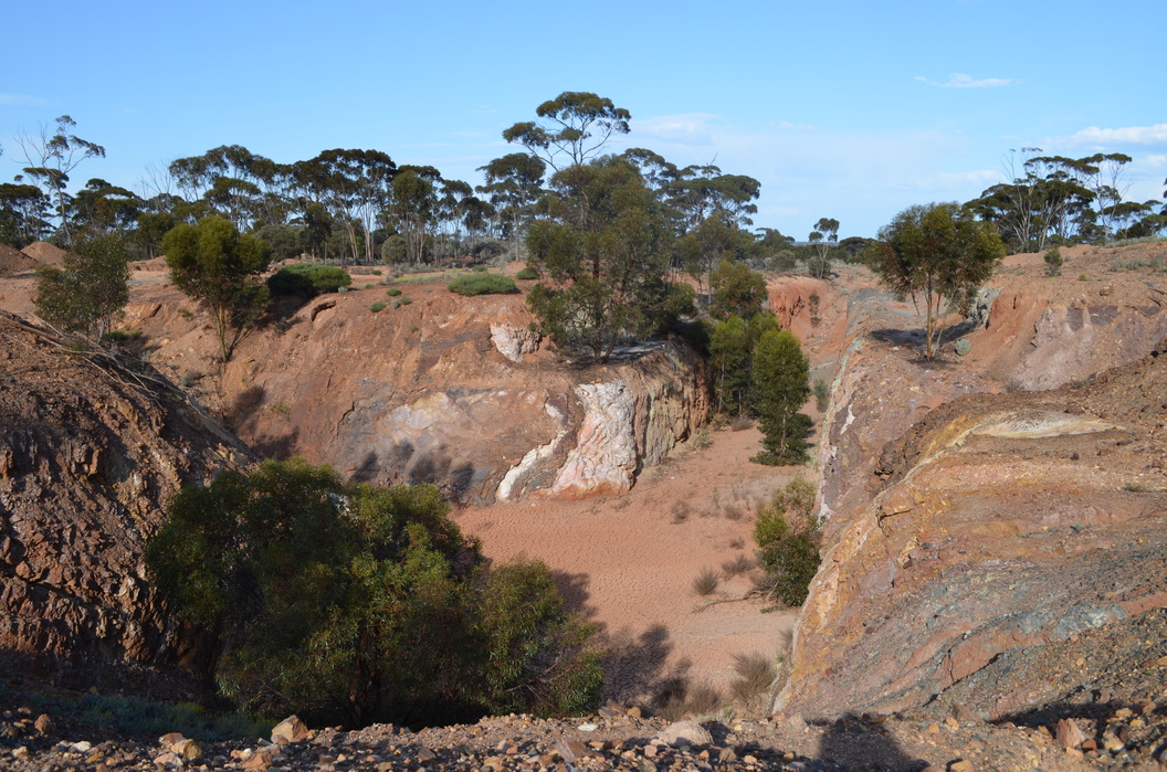
The most substantial location in the Parker Range area, mainly as it held the battery, that local prospectors would crush their ore at in the early days of the goldfield. There was also a gold mine at the site. This is located approximately 25 kilometres south of Marvel Loch, 1 kilometre south of the Buffalo South gold prospect, and borders the east side of the Marvel Loch-Forrestania Road. For a battery location the site is not extensive.
The Spring Hill mine consists of a 200 metre long open pit 5 to 10 metres deep. At the base of the pit are two shafts accessing several stoped areas.
It is thought the mine was developed shortly after gold was discovered in the area in 1888. The Carlyle was an early name for the mine in the early to mid 1890's. It was developed by the Carlyle Gold Mining Company. One writer states the mine had a sickly and troublesome career in its early years. Like many mines in the area, activity hit a low ebb in 1892, when the incredibly rich Coolgardie field was discovered, and most miners in the area fled to it. So did the battery, which was re-erected on the famous Bayley's Reward mine at Coolgardie. By 1895, a 10 head battery had been re-built on the site. The battery was almost sold again in 1897 to pay a 400 pound debt, based on some judgement in the Warden's Court.
In 1909 it is stated Spring Hill is the only mine being developed at the time in the area. The underground workings extend to 150 feet below the surface and along strike for 300 feet, on a 12 foot wide lode. Fourteen men are employed at the mine. It contains at this point a 5 head battery, which was later extended to 10 head, although it appears only 5 head was ever running due to a lack of ore, and meagre water supplies. Alex Patterson owns the battery and mine.
Information about many of the gold mines on this field is limited. The next report is 1923, although adds little new. GML 724, 5 acres, Spring Hill. The main shaft is still at 150 feet, on a lode of quartz, ironstone, and occasional kaolin, the latter yielding the most gold. Patterson still owns the operation. Crushings are noted for the mine and various local prospectors across the period, but appears to end in 1925.
The estimated resource at the site is 406 700 tonnes of ore at 2.0 g/t yielding 25 750 ounces of gold.
Commodity List
This is a list of exploitable or exploited mineral commodities recorded at this locality.Mineral List
3 valid minerals.
Rock Types Recorded
Select Rock List Type
Alphabetical List Tree DiagramRegional Geology
This geological map and associated information on rock units at or nearby to the coordinates given for this locality is based on relatively small scale geological maps provided by various national Geological Surveys. This does not necessarily represent the complete geology at this locality but it gives a background for the region in which it is found.
Click on geological units on the map for more information. Click here to view full-screen map on Macrostrat.org
| Archean 2500 - 4000 Ma ID: 724794 | mafic extrusive rocks 74255 Age: Archean (2500 - 4000 Ma) Description: Metabasalt, high-Mg basalt, tholeiitic basalt, carbonated basalt, agglomerate, mafic schist, dolerite, amphibolite; porphyritic basalt and dolerite; komatiitic basalt; mafic pyroclastics; minor mafic schist with granite intercalations Comments: igneous mafic volcanic; synthesis of multiple published descriptions Lithology: Igneous mafic volcanic Reference: Raymond, O.L., Liu, S., Gallagher, R., Zhang, W., Highet, L.M. Surface Geology of Australia 1:1 million scale dataset 2012 edition. Commonwealth of Australia (Geoscience Australia). [5] |
| Neoarchean - Mesoarchean 2500 - 3200 Ma ID: 3189632 | Archean volcanic rocks Age: Archean (2500 - 3200 Ma) Comments: Yilgarn Craton Lithology: Greenstone belt; mafic-ultramafic volcanic rocks Reference: Chorlton, L.B. Generalized geology of the world: bedrock domains and major faults in GIS format: a small-scale world geology map with an extended geological attribute database. doi: 10.4095/223767. Geological Survey of Canada, Open File 5529. [154] |
Data and map coding provided by Macrostrat.org, used under Creative Commons Attribution 4.0 License
References
External Links


Spring Hill Gold Mine, Parker Range Goldfield, Yilgarn Shire, Western Australia, Australia