Burtville Goldfield, Laverton Shire, Western Australia, Australiai
| Regional Level Types | |
|---|---|
| Burtville Goldfield | Ore Field |
| Laverton Shire | Shire |
| Western Australia | State |
| Australia | Country |
This page is currently not sponsored. Click here to sponsor this page.


Latitude & Longitude (WGS84):
28° 47' 10'' South , 122° 39' 7'' East
Latitude & Longitude (decimal):
Locality type:
Köppen climate type:
Burtville is 29 kilometres south-east of Laverton, on the Merolia Road. Gold was discovered in the area by Billy Frost and James Tregurtha in 1897. They pegged the Nil Desperandum and Wanderer leases. The first they gave away and subsequent parties obtain 100 000 pounds money-wise of gold from it. Meanwhile Frost and Tregurtha worked the Wanderer lease for two years for little result.
The town was gazetted Merolia (a local indigenous word for the area) in 1902, but soon after it was re-named Burtville, after the Mount Margaret Goldfield Chief Mining Warden, Archibald Edmund Burt. By 1903, the town boasted a population of 400 people. It had a 10 head state battery, another 5 head battery known as the Burtville Reduction Works, and another private battery which crushed for prospectors on the Sons of Westralia lease. By 1916, the population of the town was only 45.
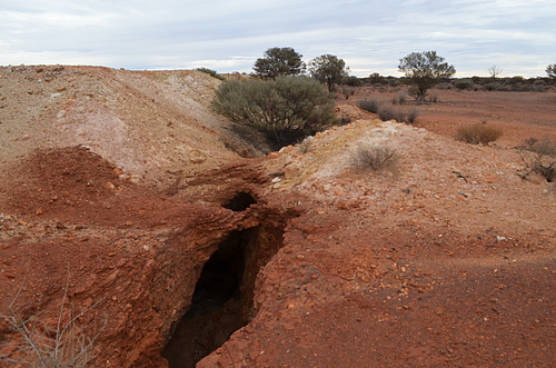
It was always a prospector field, with consequently limited information about individual mines. Modern mining has seen a small abandoned open pit at Burtville and another at the Mikado lease to the south. Numerous historic shafts are found east and south of the Burtville pit, extending south to the former town site. Nothing remains of the town other than some derelict tin shacks, stone walls, building foundations, old car bodies, and mining machinery relicts. The cemetery is west of the pit, all but one of the thirty-two souls buried here having met a violent death. There are some groupings of shafts to the south at Black Swan/Sons of Westralia.
Billy Frost was born in 1862, as William Taylor Frost, on a sailing ship in the Bay of Biscay to Scottish parents. They settled in Queensland. His stern up-bringing led Billy to rebel, and at a young age left to become a stockman in Queensland, the Northern Territory, and eventually northern Western Australia.
In the late 1890's he drifted down to the gold rushes, and discovered the Siberia and Goongarrie Goldfields, the Premier mine at Kunanalling, Lass O'Gowrie at Darlot, amongst others. He obtained enough money to leave in 1902 to search for gold at the Klondike, West Africa, British Guiana, Mexico and the Panama, with no success. Returning to Western Australia broke, he returned to stock work.
Frost has gained in history the status of a larger than life character. Through his droving work he was able to gain skills, which enabled him to travel over vast desolate countryside, that a bank clerk from Melbourne arriving at the Coolgardie gold fields could only dream about. One of his prospector mates, James Tregurtha, was an avid writer, and much information remains about Billy as a result. The truth is somewhat less romantic. His wanderlust caused him to abandon his gold finds to others. A hard living, hard drinking life takes its toll.
On April 28 1926, Billy is camped at Five Mile Well, Gilliatt Road, Mackinlay Queensland. Michael Farley and Mick Ford were with him. They had been drinking for several days. Frost gave Ford money to go into town to buy more grog. On returning, Frost accused him of keeping the change. An argument erupted, and in a fit of rage Ford shot Frost through the head. He died instantly. Ford was sentenced to four years gaol for the lesser charge of manslaughter.
James Tregurtha led a more steady life. He was born at Deniliquin New South Wales in 1867. He left for the goldfields at Croydon, the Pilbara, and then those around Coolgardie. With Frost in 1896 they trekked across unexplored territory from Oodnadatta to Lake Darlot, via the Warburton Ranges. After failing to find gold at the Yukon in North America, he returned to Western Australia, working as a blacksmith in Pingelly, fighting in France during World War One, then property investment in Perth. He died aged 92.
Select Mineral List Type
Standard Detailed Gallery Strunz Chemical ElementsCommodity List
This is a list of exploitable or exploited mineral commodities recorded from this region.Mineral List
Mineral list contains entries from the region specified including sub-localities7 valid minerals.
Rock Types Recorded
Note: data is currently VERY limited. Please bear with us while we work towards adding this information!
Rock list contains entries from the region specified including sub-localities
Select Rock List Type
Alphabetical List Tree DiagramDetailed Mineral List:
| ⓘ Gold Formula: Au Localities: Reported from at least 19 localities in this region. Reference: Gibson, C. G. (1906) The Laverton, Burtville, and Erlistoun Auriferous Belt, Mt. Margaret Goldfield. Western Australia Geological Survey Bulletin 24. |
| ⓘ Hematite Formula: Fe2O3 Reference: Gibson, C. G. (1906) The Laverton, Burtville, and Erlistoun Auriferous Belt, Mt. Margaret Goldfield. Western Australia Geological Survey Bulletin 24. |
| ⓘ Kaolinite Formula: Al2(Si2O5)(OH)4 Reference: Kalgoorlie Miner newspaper (1947), Nil Desperandum 47 DWT. On Plate, 23/12/1947 |
| ⓘ Nontronite Formula: Na0.3Fe2((Si,Al)4O10)(OH)2 · nH2O Locality: Sons of Westralia Gold Mine, Burtville Goldfield, Laverton Shire, Western Australia, Australia Reference: Gibson, C. G. (1906) The Laverton, Burtville, and Erlistoun Auriferous Belt, Mt. Margaret Goldfield. Western Australia Geological Survey Bulletin 24. |
| ⓘ Pyrite Formula: FeS2 Reference: Gibson, C. G. (1906) The Laverton, Burtville, and Erlistoun Auriferous Belt, Mt. Margaret Goldfield. Western Australia Geological Survey Bulletin 24. |
| ⓘ Quartz Formula: SiO2 Localities: Reported from at least 10 localities in this region. Reference: Gibson, C. G. (1906) The Laverton, Burtville, and Erlistoun Auriferous Belt, Mt. Margaret Goldfield. Western Australia Geological Survey Bulletin 24. |
| ⓘ Quartz var. Jasper Reference: Gibson, C. G. (1906) The Laverton, Burtville, and Erlistoun Auriferous Belt, Mt. Margaret Goldfield. Western Australia Geological Survey Bulletin 24. |
| ⓘ Talc Formula: Mg3Si4O10(OH)2 Reference: Blewett, R.S., Czarnota, K. (2007), Tectnostratigraphic Architecture and Uplift History of the Eastern Yilgarn Craton, Module 3, Terrane Structure, Project Y1-P763, Geoscience Australia, Record, Commonwealth of Australia, 2007 |
| ⓘ 'Tourmaline' Formula: AD3G6 (T6O18)(BO3)3X3Z Reference: Simpson, E.S. (1948), Minerals of Western Australia, Vol 2, p 218 |
Gallery:
List of minerals arranged by Strunz 10th Edition classification
| Group 1 - Elements | |||
|---|---|---|---|
| ⓘ | Gold | 1.AA.05 | Au |
| Group 2 - Sulphides and Sulfosalts | |||
| ⓘ | Pyrite | 2.EB.05a | FeS2 |
| Group 4 - Oxides and Hydroxides | |||
| ⓘ | Hematite | 4.CB.05 | Fe2O3 |
| ⓘ | Quartz | 4.DA.05 | SiO2 |
| ⓘ | var. Jasper | 4.DA.05 | SiO2 |
| Group 9 - Silicates | |||
| ⓘ | Kaolinite | 9.ED.05 | Al2(Si2O5)(OH)4 |
| ⓘ | Nontronite | 9.EC.40 | Na0.3Fe2((Si,Al)4O10)(OH)2 · nH2O |
| ⓘ | Talc | 9.EC.05 | Mg3Si4O10(OH)2 |
| Unclassified Minerals, Rocks, etc. | |||
| ⓘ | 'Tourmaline' | - | AD3G6 (T6O18)(BO3)3X3Z |
List of minerals for each chemical element
| H | Hydrogen | |
|---|---|---|
| H | ⓘ Nontronite | Na0.3Fe2((Si,Al)4O10)(OH)2 · nH2O |
| H | ⓘ Talc | Mg3Si4O10(OH)2 |
| H | ⓘ Kaolinite | Al2(Si2O5)(OH)4 |
| B | Boron | |
| B | ⓘ Tourmaline | AD3G6 (T6O18)(BO3)3X3Z |
| O | Oxygen | |
| O | ⓘ Quartz | SiO2 |
| O | ⓘ Nontronite | Na0.3Fe2((Si,Al)4O10)(OH)2 · nH2O |
| O | ⓘ Hematite | Fe2O3 |
| O | ⓘ Talc | Mg3Si4O10(OH)2 |
| O | ⓘ Kaolinite | Al2(Si2O5)(OH)4 |
| O | ⓘ Tourmaline | AD3G6 (T6O18)(BO3)3X3Z |
| Na | Sodium | |
| Na | ⓘ Nontronite | Na0.3Fe2((Si,Al)4O10)(OH)2 · nH2O |
| Mg | Magnesium | |
| Mg | ⓘ Talc | Mg3Si4O10(OH)2 |
| Al | Aluminium | |
| Al | ⓘ Nontronite | Na0.3Fe2((Si,Al)4O10)(OH)2 · nH2O |
| Al | ⓘ Kaolinite | Al2(Si2O5)(OH)4 |
| Si | Silicon | |
| Si | ⓘ Quartz | SiO2 |
| Si | ⓘ Nontronite | Na0.3Fe2((Si,Al)4O10)(OH)2 · nH2O |
| Si | ⓘ Talc | Mg3Si4O10(OH)2 |
| Si | ⓘ Kaolinite | Al2(Si2O5)(OH)4 |
| S | Sulfur | |
| S | ⓘ Pyrite | FeS2 |
| Fe | Iron | |
| Fe | ⓘ Pyrite | FeS2 |
| Fe | ⓘ Nontronite | Na0.3Fe2((Si,Al)4O10)(OH)2 · nH2O |
| Fe | ⓘ Hematite | Fe2O3 |
| Au | Gold | |
| Au | ⓘ Gold | Au |
References
Sort by
Year (asc) Year (desc) Author (A-Z) Author (Z-A)Gibson, C. G. (1906) The Laverton, Burtville, and Erlistoun Auriferous Belt, Mt. Margaret Goldfield. Western Australia Geological Survey Bulletin 24.
The Leonora Miner newspaper (1926), Early Days Identity. Death of Prospector Billy Frost, 15/05/1926
Tregurtha, J. (1996), Leaves from a Prospectors Diary, 1996
External Links
Localities in this Region
- Western Australia
- Western Australia
- Laverton Shire
- Burtville Goldfield
- Hard Lump Gold Mine
- Karridale Gold Mine
- Mikado Gold Mine (Hudson Consolidated; Brightstar; Alpha; Beta; General Bridges)
- Mount Weld Consols Gold Mine (Cartlidge)
- Nil Desperandum Gold Mine (Burtville)
- Oldfield Surprise Gold Mine (Oldfield; Surprise)
- Riddle Gold Mine (Lone Hand)
- Savage Captain Gold Mine
- Sons of Westralia Gold Mine
- Tempus Gold Mine
- Burtville Goldfield
- Laverton Shire
Other Regions, Features and Areas containing this locality
Australia
- Western Australia
- West Australian ElementCraton
- Windarra Nickel Metallogenic ProvinceGeologic Province
- Yilgarn CratonCraton
Australian PlateTectonic Plate
This page contains all mineral locality references listed on mindat.org. This does not claim to be a complete list. If you know of more minerals from this site, please register so you can add to our database. This locality information is for reference purposes only. You should never attempt to
visit any sites listed in mindat.org without first ensuring that you have the permission of the land and/or mineral rights holders
for access and that you are aware of all safety precautions necessary.


Burtville Goldfield, Laverton Shire, Western Australia, Australia