Mount Carnage Gold Mine (Carnage), Ora Banda Goldfield, Kalgoorlie-Boulder Shire, Western Australia, Australiai
| Regional Level Types | |
|---|---|
| Mount Carnage Gold Mine (Carnage) | Mine |
| Ora Banda Goldfield | Ore Field |
| Kalgoorlie-Boulder Shire | Shire |
| Western Australia | State |
| Australia | Country |


| Latitude & Longitude (WGS84): | 30° 22' 50'' South , 120° 56' 16'' East |
|---|---|
| Latitude & Longitude (decimal): | -30.38079,120.93803 |
| GeoHash: | G#: qdw50j27h |
| Locality type: | Mine |
| Köppen climate type: | BSh : Hot semi-arid (steppe) climate |
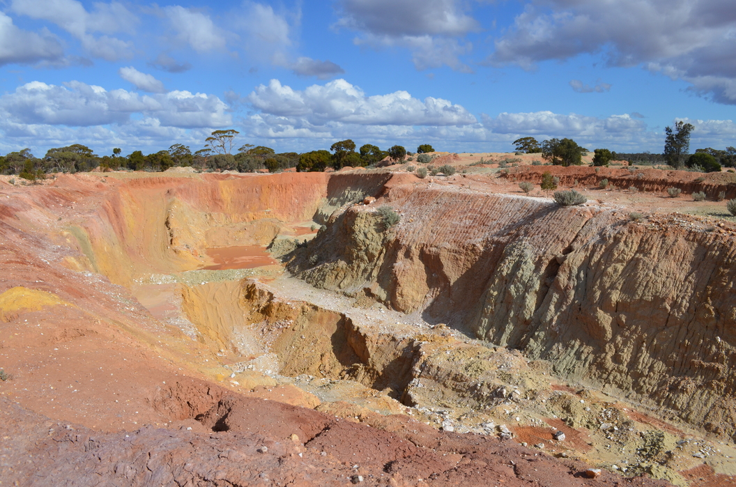
A little used road/track heads generally west of Ora Banda to the Rowles Lagoon Conservation Park. About 12 kilometres west of Ora Banda, is the Carnage mine, bordering the south side of the track. In consists of a shallow degraded small open pit, and windswept area of remnant battery sands.
Little information was found. It appears to have been active from the very early Twentieth Century, and contained a ten head battery, which crushed for the public. Minor prospector activity was found across several decades in the area.
In 1913, Constable Hunt was following the tracks of a Carnage battery thief. He accidently shot himself through the arm, the bullet passing through the hat also of Reagan, a prospector accompanying him. The Wild West this is not.
The Premier mine is noted a few hundred yards from the Carnage battery, which by 1908 had extracted 600 tonnes of ore for 1500 ounces of gold. Owned Chakley and party.
Regions containing this locality
Select Mineral List Type
Standard Detailed Strunz Dana Chemical ElementsCommodity List
This is a list of exploitable or exploited mineral commodities recorded at this locality.Mineral List
2 valid minerals.
List of minerals arranged by Strunz 10th Edition classification
| Group 1 - Elements | |||
|---|---|---|---|
| ⓘ | Gold | 1.AA.05 | Au |
| Group 2 - Sulphides and Sulfosalts | |||
| ⓘ | Pyrite | 2.EB.05a | FeS2 |
List of minerals arranged by Dana 8th Edition classification
| Group 1 - NATIVE ELEMENTS AND ALLOYS | |||
|---|---|---|---|
| Metals, other than the Platinum Group | |||
| ⓘ | Gold | 1.1.1.1 | Au |
| Group 2 - SULFIDES | |||
| AmBnXp, with (m+n):p = 1:2 | |||
| ⓘ | Pyrite | 2.12.1.1 | FeS2 |
List of minerals for each chemical element
| S | Sulfur | |
|---|---|---|
| S | ⓘ Pyrite | FeS2 |
| Fe | Iron | |
| Fe | ⓘ Pyrite | FeS2 |
| Au | Gold | |
| Au | ⓘ Gold | Au |
Regional Geology
This geological map and associated information on rock units at or nearby to the coordinates given for this locality is based on relatively small scale geological maps provided by various national Geological Surveys. This does not necessarily represent the complete geology at this locality but it gives a background for the region in which it is found.
Click on geological units on the map for more information. Click here to view full-screen map on Macrostrat.org
| Quaternary 0 - 2.588 Ma ID: 931895 | colluvium 38491 Age: Pleistocene (0 - 2.588 Ma) Description: Colluvium and/or residual deposits, sheetwash, talus, scree; boulder, gravel, sand; may include minor alluvial or sand plain deposits, local calcrete and reworked laterite Comments: regolith; synthesis of multiple published descriptions Lithology: Regolith Reference: Raymond, O.L., Liu, S., Gallagher, R., Zhang, W., Highet, L.M. Surface Geology of Australia 1:1 million scale dataset 2012 edition. Commonwealth of Australia (Geoscience Australia). [5] |
| Neoarchean - Mesoarchean 2500 - 3200 Ma ID: 3187518 | Archean volcanic rocks Age: Archean (2500 - 3200 Ma) Comments: Yilgarn Craton Lithology: Greenstone belt; mafic-ultramafic volcanic rocks Reference: Chorlton, L.B. Generalized geology of the world: bedrock domains and major faults in GIS format: a small-scale world geology map with an extended geological attribute database. doi: 10.4095/223767. Geological Survey of Canada, Open File 5529. [154] |
Data and map coding provided by Macrostrat.org, used under Creative Commons Attribution 4.0 License
References
Sort by
Year (asc) Year (desc) Author (A-Z) Author (Z-A)


Mount Carnage Gold Mine, Ora Banda Goldfield, Kalgoorlie-Boulder Shire, Western Australia, Australia