Florence, Lane Co., Oregon, USA


| Latitude & Longitude (WGS84): | 43° 58' 57'' North , 124° 5' 59'' West |
|---|---|
| Latitude & Longitude (decimal): | 43.98262,-124.09984 |
| GeoHash: | G#: 9pzf0nc32 |
| Köppen climate type: | Csb : Warm-summer Mediterranean climate |
No description has been added for this locality. Can you add one?
Select Mineral List Type
Standard Detailed Strunz Dana Chemical ElementsMineral List
Mineral list contains entries from the region specified including sub-localities4 valid minerals.
Detailed Mineral List:
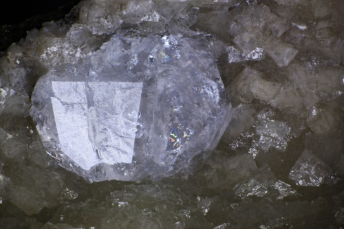
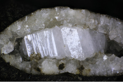
| ⓘ Analcime Formula: Na(AlSi2O6) · H2O |
| ⓘ Calcite Formula: CaCO3 |
| ⓘ 'Gmelinite' |
| ⓘ Natrolite Formula: Na2Al2Si3O10 · 2H2O |
| ⓘ Quartz Formula: SiO2 |
| ⓘ Quartz var: Chalcedony Formula: SiO2 |


List of minerals arranged by Strunz 10th Edition classification
| Group 4 - Oxides and Hydroxides | |||
|---|---|---|---|
| ⓘ | Quartz | 4.DA.05 | SiO2 |
| ⓘ | var: Chalcedony | 4.DA.05 | SiO2 |
| Group 5 - Nitrates and Carbonates | |||
| ⓘ | 'Calcite' | 5.AB.05 | CaCO3 |
| Group 9 - Silicates | |||
| ⓘ | 'Analcime' | 9.GB.05 | Na(AlSi2O6) · H2O |
| ⓘ | Natrolite | 9.GA.05 | Na2Al2Si3O10 · 2H2O |
| Unclassified Minerals, Rocks, etc. | |||
| ⓘ | Gmelinite | - | |
List of minerals arranged by Dana 8th Edition classification
| Group 14 - ANHYDROUS NORMAL CARBONATES | |||
|---|---|---|---|
| A(XO3) | |||
| ⓘ | Calcite | 14.1.1.1 | CaCO3 |
| Group 75 - TECTOSILICATES Si Tetrahedral Frameworks | |||
| Si Tetrahedral Frameworks - SiO2 with [4] coordinated Si | |||
| ⓘ | Quartz | 75.1.3.1 | SiO2 |
| Group 77 - TECTOSILICATES Zeolites | |||
| Zeolite group - True zeolites | |||
| ⓘ | Analcime | 77.1.1.1 | Na(AlSi2O6) · H2O |
| ⓘ | Natrolite | 77.1.5.1 | Na2Al2Si3O10 · 2H2O |
| Unclassified Minerals, Rocks, etc. | |||
| ⓘ | 'Gmelinite' | - | |
| ⓘ | Quartz var: Chalcedony | - | SiO2 |
List of minerals for each chemical element
| H | Hydrogen | |
|---|---|---|
| H | ⓘ Analcime | Na(AlSi2O6) · H2O |
| H | ⓘ Natrolite | Na2Al2Si3O10 · 2H2O |
| C | Carbon | |
| C | ⓘ Calcite | CaCO3 |
| O | Oxygen | |
| O | ⓘ Analcime | Na(AlSi2O6) · H2O |
| O | ⓘ Calcite | CaCO3 |
| O | ⓘ Quartz (var: Chalcedony) | SiO2 |
| O | ⓘ Natrolite | Na2Al2Si3O10 · 2H2O |
| O | ⓘ Quartz | SiO2 |
| Na | Sodium | |
| Na | ⓘ Analcime | Na(AlSi2O6) · H2O |
| Na | ⓘ Natrolite | Na2Al2Si3O10 · 2H2O |
| Al | Aluminium | |
| Al | ⓘ Analcime | Na(AlSi2O6) · H2O |
| Al | ⓘ Natrolite | Na2Al2Si3O10 · 2H2O |
| Si | Silicon | |
| Si | ⓘ Analcime | Na(AlSi2O6) · H2O |
| Si | ⓘ Quartz (var: Chalcedony) | SiO2 |
| Si | ⓘ Natrolite | Na2Al2Si3O10 · 2H2O |
| Si | ⓘ Quartz | SiO2 |
| Ca | Calcium | |
| Ca | ⓘ Calcite | CaCO3 |
Regional Geology
This geological map and associated information on rock units at or nearby to the coordinates given for this locality is based on relatively small scale geological maps provided by various national Geological Surveys. This does not necessarily represent the complete geology at this locality but it gives a background for the region in which it is found.
Click on geological units on the map for more information. Click here to view full-screen map on Macrostrat.org
| Holocene 0 - 0.0117 Ma ID: 1497050 | Quaternary surficial deposits; Beach deposits Age: Anthropocene (0 - 0.0117 Ma) Description: Deflation plain; fine grained sediments Lithology: Major:: {sand} Minor:: {peat} Reference: R.L. Smith, W.P. Roe (compilers). Oregon Geologic Data Compilation, release 6. State of Oregon Department of Geology and Mineral Industries. [20] |
| Pleistocene 0.0117 - 2.588 Ma ID: 2914361 | Lacustrine and fluvial sedimentary rocks Age: Pleistocene (0.0117 - 2.588 Ma) Stratigraphic Name: Willamette Silt; Gresham Formation; Estacada Formation Description: Unconsolidated to semiconsolidated lacustrine clay, silt, sand, and gravel; in places includes mudflow and fluvial deposits and discontinuous layers of peat. Includes older alluvium and related deposits of Piper (1942), Willamette Silt (Allison, 1953; Wells and Peck, 1961), alluvial silt, sand, and gravel that form terrace deposits of Wells and others (1983), and Gresham and Estacada Formations of Trimble (1963). Includes deltaic gravel and sand and gravel bars, in pluvial lake basins in southeastern part of map area. In Rome Basin, includes discontinuous layers of poorly consolidated conglomerate characterized by well-rounded, commonly polished pebbles of chert and pebbles and cobbles of quartzite. In places contains mollusks or vertebrate fossils indicating Pleistocene age; mostly deposits of late Pleistocene age, but locally includes some deposits of early Holocene age. Includes Touchet Beds of Flint (1938), deposits of valley terraces of Newcomb (1965), and, in southeast Oregon, basin-filling deposits that incorporate Mazama ash deposits (Qma, Qmp) in the youngest layers Lithology: Major:{clay,silt,sand}, Minor:{gravel}, Incidental:{peat} Reference: Horton, J.D., C.A. San Juan, and D.B. Stoeser. The State Geologic Map Compilation (SGMC) geodatabase of the conterminous United States. doi: 10.3133/ds1052. U.S. Geological Survey Data Series 1052. [133] |
| Eocene 33.9 - 56 Ma ID: 3192414 | Cenozoic sedimentary rocks Age: Eocene (33.9 - 56 Ma) Lithology: Sedimentary rocks Reference: Chorlton, L.B. Generalized geology of the world: bedrock domains and major faults in GIS format: a small-scale world geology map with an extended geological attribute database. doi: 10.4095/223767. Geological Survey of Canada, Open File 5529. [154] |
Data and map coding provided by Macrostrat.org, used under Creative Commons Attribution 4.0 License
Localities in this RegionShow map
- Oregon
- Lane Co.
- Florence
- Lane Co.


Sea Lion Point, Florence, Lane Co., Oregon, USA