KWK Victoria, Sobięcin, Wałbrzych, Lower Silesian Voivodeship, Polandi
| Regional Level Types | |
|---|---|
| KWK Victoria | Mine (Lost) |
| Sobięcin | Quarter |
| Wałbrzych | City |
| Lower Silesian Voivodeship | Voivodeship |
| Poland | Country |
This page is currently not sponsored. Click here to sponsor this page.


Latitude & Longitude (WGS84):
50° 45' 15'' North , 16° 14' 40'' East
Latitude & Longitude (decimal):
Type:
Mine (Lost) - last checked 2019
Köppen climate type:
Nearest Settlements:
| Place | Population | Distance |
|---|---|---|
| Boguszów-Gorce | 16,726 (2015) | 2.8km |
| Wałbrzych | 127,431 (2017) | 3.4km |
| Szczawno-Zdrój | 5,586 (2010) | 5.5km |
| Dziećmorowice | 1,162 (2010) | 7.7km |
| Jedlina-Zdrój | 5,062 (2016) | 8.1km |
Mindat Locality ID:
333696
Long-form identifier:
1:2:333696:3
GUID (UUID V4):
9015dc7d-e5ec-4350-aa0e-a6676451308b
Other/historical names associated with this locality:
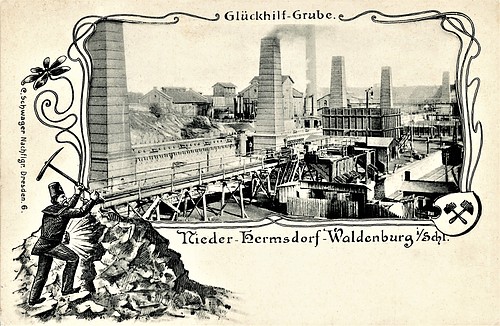
Vereinigte Glückhilf-Friedenshoffnung / Heydt Schacht
KWK Victoria
Rock Types Recorded
Note: data is currently VERY limited. Please bear with us while we work towards adding this information!
Select Rock List Type
Alphabetical List Tree DiagramList of minerals for each chemical element
Other Regions, Features and Areas containing this locality
Czech Republic/Germany/Poland
- ⭔SilesiaRegion
Czech Republic/Poland
- Central SudetesMountain Range
Eurasian PlateTectonic Plate
EuropeContinent
- Bohemian MassifMassif
- SudetesMountain Range
This page contains all mineral locality references listed on mindat.org. This does not claim to be a complete list. If you know of more minerals from this site, please register so you can add to our database. This locality information is for reference purposes only. You should never attempt to
visit any sites listed in mindat.org without first ensuring that you have the permission of the land and/or mineral rights holders
for access and that you are aware of all safety precautions necessary.


KWK Victoria, Sobięcin, Wałbrzych, Lower Silesian Voivodeship, Poland