Breitenbuchen, Oberbuchach, Kirchbach, Hermagor District, Carinthia, Austriai
| Regional Level Types | |
|---|---|
| Breitenbuchen | - not defined - |
| Oberbuchach | - not defined - |
| Kirchbach | Municipality |
| Hermagor District | District |
| Carinthia | State |
| Austria | Country |
This page is currently not sponsored. Click here to sponsor this page.


Latitude & Longitude (WGS84):
46° 37' 37'' North , 13° 6' 32'' East
Latitude & Longitude (decimal):
Köppen climate type:
Nearest Settlements:
| Place | Population | Distance |
|---|---|---|
| Gundersheim | 288 (2018) | 2.5km |
| Nölbling | 117 (2018) | 2.5km |
| Grafendorf | 515 (2018) | 3.5km |
| Reisach | 370 (2018) | 4.2km |
| Dellach | 619 (2018) | 4.5km |
Mindat Locality ID:
46219
Long-form identifier:
mindat:1:2:46219:7
GUID (UUID V4):
680ffb8f-733e-483b-b515-5325f95aeff9
Name(s) in local language(s):
Breitenbuchen, Oberbuchach, Kirchbach, Gailtaler Alpen & Karnische Alpen, Kärnten, Österreich
Iron deposit. Located near Oberbuchach, in the upper Gail valley.
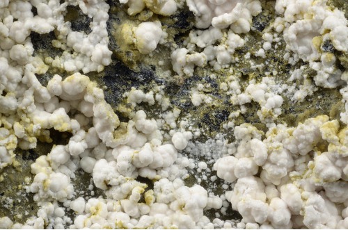
Koninckite and others were found at a "Geopunkt" of a geotrail at the Gundersdorfer Almstraße near Oberbuchach.
Select Mineral List Type
Standard Detailed Gallery Strunz Chemical ElementsDetailed Mineral List:
| ⓘ Aragonite Formula: CaCO3 References: |
| ⓘ Calcite Formula: CaCO3 References: |
| ⓘ Gypsum Formula: CaSO4 · 2H2O References: |
| ⓘ Hexahydrite Formula: MgSO4 · 6H2O References: |
| ⓘ Koninckite Formula: Fe3+PO4 · 3H2O References: |
| ⓘ Magnetite Formula: Fe2+Fe3+2O4 References: |
| ⓘ Rozenite Formula: FeSO4 · 4H2O References: |

List of minerals arranged by Strunz 10th Edition classification
| Group 4 - Oxides and Hydroxides | |||
|---|---|---|---|
| ⓘ | Magnetite | 4.BB.05 | Fe2+Fe3+2O4 |
| Group 5 - Nitrates and Carbonates | |||
| ⓘ | Calcite | 5.AB.05 | CaCO3 |
| ⓘ | Aragonite | 5.AB.15 | CaCO3 |
| Group 7 - Sulphates, Chromates, Molybdates and Tungstates | |||
| ⓘ | Rozenite | 7.CB.15 | FeSO4 · 4H2O |
| ⓘ | Hexahydrite | 7.CB.25 | MgSO4 · 6H2O |
| ⓘ | Gypsum | 7.CD.40 | CaSO4 · 2H2O |
| Group 8 - Phosphates, Arsenates and Vanadates | |||
| ⓘ | Koninckite | 8.CE.55 | Fe3+PO4 · 3H2O |
List of minerals for each chemical element
| H | Hydrogen | |
|---|---|---|
| H | ⓘ Gypsum | CaSO4 · 2H2O |
| H | ⓘ Hexahydrite | MgSO4 · 6H2O |
| H | ⓘ Koninckite | Fe3+PO4 · 3H2O |
| H | ⓘ Rozenite | FeSO4 · 4H2O |
| C | Carbon | |
| C | ⓘ Aragonite | CaCO3 |
| C | ⓘ Calcite | CaCO3 |
| O | Oxygen | |
| O | ⓘ Aragonite | CaCO3 |
| O | ⓘ Calcite | CaCO3 |
| O | ⓘ Gypsum | CaSO4 · 2H2O |
| O | ⓘ Hexahydrite | MgSO4 · 6H2O |
| O | ⓘ Koninckite | Fe3+PO4 · 3H2O |
| O | ⓘ Magnetite | Fe2+Fe23+O4 |
| O | ⓘ Rozenite | FeSO4 · 4H2O |
| Mg | Magnesium | |
| Mg | ⓘ Hexahydrite | MgSO4 · 6H2O |
| P | Phosphorus | |
| P | ⓘ Koninckite | Fe3+PO4 · 3H2O |
| S | Sulfur | |
| S | ⓘ Gypsum | CaSO4 · 2H2O |
| S | ⓘ Hexahydrite | MgSO4 · 6H2O |
| S | ⓘ Rozenite | FeSO4 · 4H2O |
| Ca | Calcium | |
| Ca | ⓘ Aragonite | CaCO3 |
| Ca | ⓘ Calcite | CaCO3 |
| Ca | ⓘ Gypsum | CaSO4 · 2H2O |
| Fe | Iron | |
| Fe | ⓘ Koninckite | Fe3+PO4 · 3H2O |
| Fe | ⓘ Magnetite | Fe2+Fe23+O4 |
| Fe | ⓘ Rozenite | FeSO4 · 4H2O |
Other Regions, Features and Areas containing this locality
Eurasian PlateTectonic Plate
EuropeContinent
- The AlpsMountain Range
- Carnic and Gailtal AlpsGroup of Mountain Ranges
- Carnic AlpsMountain Range
- Carnic and Gailtal AlpsGroup of Mountain Ranges
This page contains all mineral locality references listed on mindat.org. This does not claim to be a complete list. If you know of more minerals from this site, please register so you can add to our database. This locality information is for reference purposes only. You should never attempt to
visit any sites listed in mindat.org without first ensuring that you have the permission of the land and/or mineral rights holders
for access and that you are aware of all safety precautions necessary.
References


Breitenbuchen, Oberbuchach, Kirchbach, Hermagor District, Carinthia, Austria