Köfels, Umhausen, Imst District, Tyrol, Austriai
| Regional Level Types | |
|---|---|
| Köfels | Village |
| Umhausen | Municipality |
| Imst District | District |
| Tyrol | State |
| Austria | Country |
This page is currently not sponsored. Click here to sponsor this page.


Latitude & Longitude (WGS84):
47° 7' 13'' North , 10° 55' 3'' East
Latitude & Longitude (decimal):
Type:
Köppen climate type:
Nearest Settlements:
| Place | Population | Distance |
|---|---|---|
| Umhausen | 1,840 (2018) | 1.8km |
| Niederthai | 354 (2018) | 3.8km |
| Östen | 332 (2018) | 5.1km |
| Tumpen | 644 (2018) | 5.3km |
| Längenfeld | 4,611 (2018) | 6.5km |
Mindat Locality ID:
58673
Long-form identifier:
mindat:1:2:58673:4
GUID (UUID V4):
f101a4b0-3a6c-4d92-bf22-a2da4e7b76bd
Name(s) in local language(s):
Köfels, Umhausen, Ötztal, Nordtirol, Tirol, Österreich
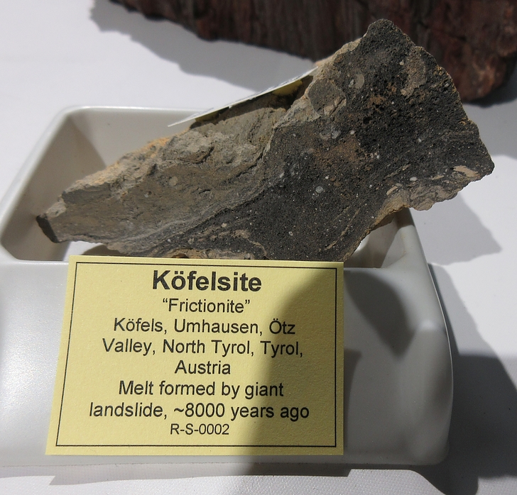
Huge landslide (8000 years ago, 6 km long and with a volume of about 2 km3), with ductile deformation at very high strain rate in a narrow shear zone: intense friction raised temperature to melting, leading to the formation of a pumiceous glass thin layer.
The glass resulted from friction thermometamorphism of biotite-amphibole gneisses and not from volcanism or shock due to impact of a meteor (as was assumed by earlier authors).
Extremely high indoor radon concentrations in the village Umhausen (built on landslide rock material) led to detailed studies on the reasons. It was found that high concentrations can not be related to uranium anomalies or large-scale fault zones. Instead, the giant landslide, with its highly fractured and crushed orthogneisses, is the only possible source of radon, despite the fact that the U and Ra content of the rocks is by no means exceptional. The most important factors producing high radon emanation rates are the production of a high active surface area and circulation pathways for radon-enriched soil air by brittle deformation due to the impact of the landslide mass (Purtscheller et al., 1995).
Select Mineral List Type
Standard Detailed Gallery Strunz Chemical ElementsMineral List
3 valid minerals.
Rock Types Recorded
Note: data is currently VERY limited. Please bear with us while we work towards adding this information!
Select Rock List Type
Alphabetical List Tree DiagramDetailed Mineral List:
| ⓘ 'Glass' References: |
| ⓘ Lechatelierite Formula: SiO2 |
| ⓘ Metazeunerite Formula: Cu(UO2)2(AsO4)2 · 8H2O |
| ⓘ 'Pseudotachylyte var. Köfelsit' References: |
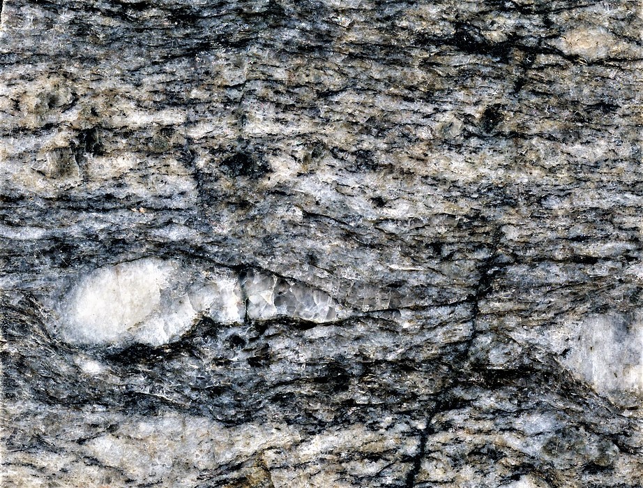
| ⓘ Quartz Formula: SiO2 Description: Presents numerous undulatory extinctions, dislocation loops, subgrain boundaries, dislocation in climb configuration forming junctions, and also evidence of lattice friction. References: |
Gallery:
List of minerals arranged by Strunz 10th Edition classification
| Group 4 - Oxides and Hydroxides | |||
|---|---|---|---|
| ⓘ | Quartz | 4.DA.05 | SiO2 |
| ⓘ | Lechatelierite | 4.DA.30 | SiO2 |
| Group 8 - Phosphates, Arsenates and Vanadates | |||
| ⓘ | Metazeunerite | 8.EB.10 | Cu(UO2)2(AsO4)2 · 8H2O |
| Unclassified | |||
| ⓘ | 'Glass' | - | |
| ⓘ | 'Pseudotachylyte var. Köfelsit' | - | |
List of minerals for each chemical element
| H | Hydrogen | |
|---|---|---|
| H | ⓘ Metazeunerite | Cu(UO2)2(AsO4)2 · 8H2O |
| O | Oxygen | |
| O | ⓘ Lechatelierite | SiO2 |
| O | ⓘ Metazeunerite | Cu(UO2)2(AsO4)2 · 8H2O |
| O | ⓘ Quartz | SiO2 |
| Si | Silicon | |
| Si | ⓘ Lechatelierite | SiO2 |
| Si | ⓘ Quartz | SiO2 |
| Cu | Copper | |
| Cu | ⓘ Metazeunerite | Cu(UO2)2(AsO4)2 · 8H2O |
| As | Arsenic | |
| As | ⓘ Metazeunerite | Cu(UO2)2(AsO4)2 · 8H2O |
| U | Uranium | |
| U | ⓘ Metazeunerite | Cu(UO2)2(AsO4)2 · 8H2O |
Other Regions, Features and Areas containing this locality
Austria
- Tyrol
- ⭔Imst - Nassereith mining districtDistrict
- Imst District
- Ötz valleyValley
- ⭔North TyrolRegion
Eurasian PlateTectonic Plate
EuropeContinent
- The AlpsMountain Range
This page contains all mineral locality references listed on mindat.org. This does not claim to be a complete list. If you know of more minerals from this site, please register so you can add to our database. This locality information is for reference purposes only. You should never attempt to
visit any sites listed in mindat.org without first ensuring that you have the permission of the land and/or mineral rights holders
for access and that you are aware of all safety precautions necessary.
References


Köfels, Umhausen, Imst District, Tyrol, Austria