|
Australia | |
|
| R.E Brown and W.J Stroud, Metallogenic Study and Mineral Deposit Data Sheets, 1997. |
|
| Henley, H. F., Brown, R. E., Brownlow, J. W., Barnes, R. G., Stroud, W. J. (2001) Grafton-Maclean Metallogenic Map (SH/56-6, SH/56-7) Metallogenic Study and Mineral Deposit Data Sheets. Geological Survey of New South Wales |
|
| Henley, H. F., Brown, R. E., Brownlow, J. W., Barnes, R. G., Stroud, W. J. (2001) Grafton-Maclean Metallogenic Map (SH/56-6, SH/56-7) Metallogenic Study and Mineral Deposit Data Sheets. Geological Survey of New South Wales |
|
| [var. Agate] Brown, R.E., Henley, H.F., Stroud, W.J. (2001) Mineral Occurrence Data Sheets, and Occurrence Lists, in Warwick-Tweed Heads 1:250 000 Sheet Area (New South Wales Portion). Vol 2. Exploration Data Package, Geological Survey of New South Wales. |
|
| Brown, R.E., Henley, H.F., Stroud, W.J. (2001) Mineral Occurrence Data Sheets, and Occurrence Lists, in Warwick-Tweed Heads 1:250 000 Sheet Area (New South Wales Portion). Vol 2. Exploration Data Package, Geological Survey of New South Wales. |
|
| Brown, R.E., Henley, H.F., Stroud, W.J. (2001) Mineral Occurrence Data Sheets, and Occurrence Lists, in Warwick-Tweed Heads 1:250 000 Sheet Area (New South Wales Portion). Vol 2. Exploration Data Package, Geological Survey of New South Wales. |
|
| [var. Agate] Gilligan, L. B., Brownlow, J. W., Cameron, R. G., Henley, H. F. (1992) Metallogenic Study and Mineral Deposit Data Sheets: Dorrigo-Coffs Harbour 1:250 000 Metallogenic Map SH/56-10, SH/56-11. Geological Survey of New South Wales, Sydney. 509pp. |
|
| Henley, H. F., Brown, R. E., Brownlow, J. W., Barnes, R. G., Stroud, W. J. (2001) Grafton-Maclean Metallogenic Map (SH/56-6, SH/56-7) Metallogenic Study and Mineral Deposit Data Sheets. Geological Survey of New South Wales |
|
| Henley, H. F., Brown, R. E., Brownlow, J. W., Barnes, R. G., Stroud, W. J. (2001) Grafton-Maclean Metallogenic Map (SH/56-6, SH/56-7) Metallogenic Study and Mineral Deposit Data Sheets. Geological Survey of New South Wales |
|
| Henley, H. F., Brown, R. E., Brownlow, J. W., Barnes, R. G., Stroud, W. J. (2001) Grafton-Maclean Metallogenic Map (SH/56-6, SH/56-7) Metallogenic Study and Mineral Deposit Data Sheets. Geological Survey of New South Wales |
|
| Henley, H. F., Brown, R. E., Brownlow, J. W., Barnes, R. G., Stroud, W. J. (2001) Grafton-Maclean Metallogenic Map (SH/56-6, SH/56-7) Metallogenic Study and Mineral Deposit Data Sheets. Geological Survey of New South Wales |
|
| Henley, H. F., Brown, R. E., Brownlow, J. W., Barnes, R. G., Stroud, W. J. (2001) Grafton-Maclean Metallogenic Map (SH/56-6, SH/56-7) Metallogenic Study and Mineral Deposit Data Sheets. Geological Survey of New South Wales |
|
| Henley, H. F., Brown, R. E., Brownlow, J. W., Barnes, R. G., Stroud, W. J. (2001) Grafton-Maclean Metallogenic Map (SH/56-6, SH/56-7) Metallogenic Study and Mineral Deposit Data Sheets. Geological Survey of New South Wales |
|
| Henley, H. F., Brown, R. E., Brownlow, J. W., Barnes, R. G., Stroud, W. J. (2001) Grafton-Maclean Metallogenic Map (SH/56-6, SH/56-7) Metallogenic Study and Mineral Deposit Data Sheets. Geological Survey of New South Wales |
|
| Byrnes, J., Slansky, E., Ferguson, A. (1983) Occurrence and significance of Laumontite cement in early Carboniferous Sandstone at Glenbawn Dam. Geological Survey of New South Wales Department of Mineral Resources, GS 1983/075. |
|
| Gilligan, L. B., Brownlow, J. W., Cameron, R. G., Henley, H. F. (1992) Metallogenic Study and Mineral Deposit Data Sheets: Dorrigo-Coffs Harbour 1:250 000 Metallogenic Map SH/56-10, SH/56-11. Geological Survey of New South Wales, Sydney. 509pp. |
|
| Brown, R.E., Stroud, W.J. (1997) Metallogenic Study and Mineral Deposit Data Sheets, Inverell 1:250 000 Metallogenic Map SH/56-5. Geological Survey of New South Wales, Sydney, 576 pages. |
|
| Henley, H. F., Brown, R. E., Brownlow, J. W., Barnes, R. G., Stroud, W. J. (2001) Grafton-Maclean Metallogenic Map (SH/56-6, SH/56-7) Metallogenic Study and Mineral Deposit Data Sheets. Geological Survey of New South Wales |
|
| Henley, H. F., Brown, R. E., Brownlow, J. W., Barnes, R. G., Stroud, W. J. (2001) Grafton-Maclean Metallogenic Map (SH/56-6, SH/56-7) Metallogenic Study and Mineral Deposit Data Sheets. Geological Survey of New South Wales |
|
| NSW Geological Survey Report GS 1965/126 |
|
| Ashley, P. M., & Hartshorn, G. K. (1988). Geological and geochemical characteristics of lode gold deposits in the Nundle Goldfield, northeastern New South Wales. New England Orogen—Tectonics and Metallogenesis, 249-263. |
|
| Brown, R.E., Henley, H.F., Stroud, W.J. (2001) Mineral Occurrence Data Sheets, and Occurrence Lists, in Warwick-Tweed Heads 1:250 000 Sheet Area (New South Wales Portion). Vol 2. Exploration Data Package, Geological Survey of New South Wales. |
|
| Brown, R.E., Henley, H.F., Stroud, W.J. (2001) Mineral Occurrence Data Sheets, and Occurrence Lists, in Warwick-Tweed Heads 1:250 000 Sheet Area (New South Wales Portion). Vol 2. Exploration Data Package, Geological Survey of New South Wales. |
|
| [var. Agate] Mineralogical Magazine, October 2006, Vol. 70(5), pp. 485–498 |
|
| Vic Cloete. |
|
| Brian Camey |
|
| Updated list originally distributed by University of Queensland |
|
| part of list University of Queensland |
|
| Eggleton, R.A., Fitzgerald, J., and Foster, L., 2011. Chrysoprase from Gumigil, Queensland. Australian Journal of Earth Science. 58, 767-776. |
|
| [Agate var. Eye Agate] |
|
| |
|
| Myatt, B. (1972) Australian and New Zealand Gemstones. Paul Hamlyn Pty Ltd., 511 pp.
Ben Grguric collection |
|
| |


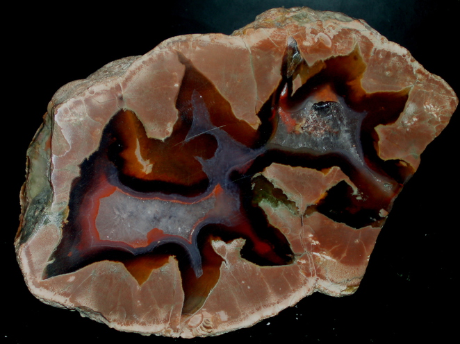


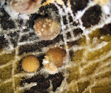


Mount Hay, Wycarbah, Rockhampton Region, Queensland, Australia