| Locality type: | Mine |
| Classification |
|---|
|
| Species: | Wulfenite |
| Formula: | Pb(MoO4) |
| Confirmation |
|---|
|
| Validity: | Believed Valid |
| Data |
|---|
|
| Mineral Data: | Click here to view Wulfenite data |
| Locality Data: | Click here to view Les Moulins Mine, Saint-Luc, Anniviers, Sierre, Valais, Switzerland |
| Data Identifiers |
|---|
|
| Mindat Occurrence Record ID: | 366853 |
| Long-form Identifier: | 1:3:366853:5 |
| GUID (UUID V4): | 50a22a35-adca-41cb-94e4-5b025b8d4253 |
| Nearest other occurrences of Wulfenite |
|---|
|
|
| 0.3km (0.2 miles) | ⓘGosan Mine, Saint-Luc, Anniviers, Sierre, Valais, Switzerland |
| 0.3km (0.2 miles) | ⓘLower Collioux Mine, Saint-Luc, Anniviers, Sierre, Valais, Switzerland |
| 2.5km (1.6 miles) | ⓘUpper Collioux Mine, Saint-Luc, Anniviers, Sierre, Valais, Switzerland |
| 20.0km (12.4 miles) | ⓘSt German, Raron, Westlich Raron, Valais, Switzerland |
| 40.3km (25.0 miles) | ⓘTête des Econduits, Mont Chemin mining district, Martigny, Valais, Switzerland |
| 40.7km (25.3 miles) | ⓘChez Larze, Mont Chemin mining district, Martigny, Valais, Switzerland |
| 41.9km (26.1 miles) | ⓘNorth slope, Le Catogne, Sembrancher, Entremont, Valais, Switzerland |
| 42.4km (26.4 miles) | ⓘHillehorn northeast slope, Chummibort, Grengiols, Östlich Raron, Valais, Switzerland |
| 43.6km (27.1 miles) | ⓘBoitses (Les Boitses), Lavey-les-Bains, Lavey-Morcles, Aigle, Vaud, Switzerland |
| 43.8km (27.2 miles) | ⓘBianco lake REE-mineralization, Veglia Alp (Alpe Veglia), Varzo, Verbano-Cusio-Ossola Province, Piedmont, Italy |
| References |
|---|
|
|
| Reference Search (possible matching items) |
|---|
 | | Book (volume) | | Aalborg amt (Denmark) Aardvarks Aardwolves Aargau (Switzerland) Aarhus amt (Denmark) Abaca fiber crop Abacus...see also Achievement tests Achromatiaceae Acid mine drainage 781.47 345.03 788.86 musical technique...Altamaha River 615.324 324 247.1 615.324 324 Switzerland Alsace (France) clothing commercial home sewing...Annatto tree Anne (Mother of the Virgin Mary), Saint : private prayers to 179.3 291.569 3 294.356...589.94 : Canton) Appenzell Ausser-Rhoden (Switzerland) 568.8 521.3 35 176 3 03 4 617.554 5 surgery |
|
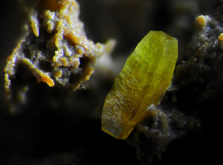


Les Moulins Mine, Saint-Luc, Anniviers, Sierre, Valais, Switzerland