| Locality type: | Mine |
| Classification |
|---|
|
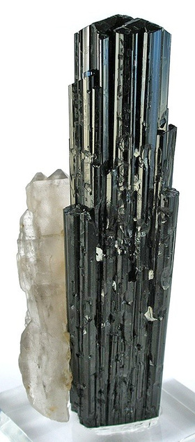
| Species: | Schorl |
| Formula: | NaFe32+Al6(Si6O18)(BO3)3(OH)3(OH) |
| Comments: | Occurs in lithia-pegmatite. |
| Confirmation |
|---|
|
| Validity: | Believed Valid |
| Associated Minerals Based on Photo Data: |
|---|
|
| Muscovite | ⓘ10 photos of Schorl associated with Muscovite at this locality. |
| Feldspar Group | 8 photos of Schorl associated with Feldspar Group at this locality. |
| Quartz | ⓘ5 photos of Schorl associated with Quartz at this locality. |
| Albite | ⓘ4 photos of Schorl associated with Albite at this locality. |
| Aquamarine | ⓘ3 photos of Schorl associated with Aquamarine at this locality. |
| Almandine | 2 photos of Schorl associated with Almandine at this locality. |
| Smoky Quartz | 2 photos of Schorl associated with Smoky Quartz at this locality. |
| Microcline | ⓘ1 photo of Schorl associated with Microcline at this locality. |
| Data |
|---|
|
| Mineral Data: | Click here to view Schorl data |
| Locality Data: | Click here to view Fano Mine (Big Pink claim; Fano-Simmons Mine; Little Blue claim; MS 4800; Simmons Mine), Little Cahuilla Mountain, Cahuilla Mining District, Riverside County, California, USA |
| Photo Gallery | View Gallery (21 photos) |
| Data Identifiers |
|---|
|
| Mindat Occurrence Record ID: | 65249 |
| Long-form Identifier: | 1:3:65249:6 |
| GUID (UUID V4): | 3cc1b5e5-4d09-42ad-8d33-e5fc545b350d |
| Nearest other occurrences of Schorl |
|---|
|
|
| 1.7km (1.1 miles) | ⓘGranitic pegmatite occurrence (group II; younger pegmatites), Little Cahuilla Mountain, Cahuilla Mining District, Riverside County, California, USA |
| 1.8km (1.1 miles) | ⓘAndalusite pegmatite (group I; older pegmatites), Little Cahuilla Mountain, Cahuilla Mining District, Riverside County, California, USA |
| 1.8km (1.1 miles) | ⓘJuan Diego Mine No. 1 (Juan Diego No. 1 deposit; Rainbow Mine; Rainbow prospects), Little Cahuilla Mountain, Cahuilla Mining District, Riverside County, California, USA |
| 2.7km (1.7 miles) | ⓘAudrey Lynn Mine (Audrey Lynne Mine; Jumping Joe claims), Little Cahuilla Mountain, Cahuilla Mining District, Riverside County, California, USA |
| 3.0km (1.8 miles) | ⓘSly Rick prospect (Green Centipede claim), Little Cahuilla Mountain, Cahuilla Mining District, Riverside County, California, USA |
| 3.4km (2.1 miles) | ⓘCrown Jewel Mine, Bautista Canyon, Cahuilla Mining District, Riverside County, California, USA |
| 4.4km (2.7 miles) | ⓘLithia Dike Mine (Lithia Dyke claim), Cahuilla Mountain, Cahuilla Mining District, Riverside County, California, USA |
| 5.1km (3.2 miles) | ⓘOlinger deposit, Anza, Anza Valley, Cahuilla Mining District, Riverside County, California, USA |
| 8.6km (5.3 miles) | ⓘAnita Mine (Magee Mine; Magee & Dougherty Mine; Sage Mine), Red Mountain, Cahuilla Mining District, Riverside County, California, USA |
| 14.7km (9.1 miles) | ⓘColumbia Mine (April Fool claim; Belo Horizonte claim; California Gem Mine; Columbia Gem Mine; Desert Rose claim; San Jacinto Gem Mine; Discovery), Thomas Mountain, Thomas Mountain [town], Cahuilla Mining District, Riverside County, California, USA |
| References |
|---|
|
|


Fano Mine, Little Cahuilla Mountain, Cahuilla Mining District, Riverside County, California, USA