| Locality type: | Occurrence |
| Classification |
|---|
|
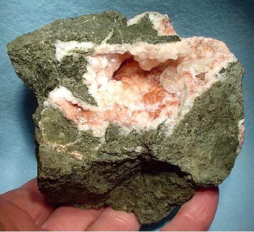
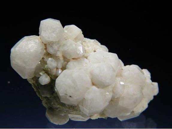
| Species: | Analcime |
| Formula: | Na(AlSi2O6) · H2O |
| Confirmation |
|---|
|
| Validity: | Believed Valid |
| Associated Minerals Based on Photo Data: |
|---|
|
| Apophyllite Group | ⓘ21 photos of Analcime associated with Apophyllite Group at this locality. |
| Datolite | ⓘ14 photos of Analcime associated with Datolite at this locality. |
| Natrolite | ⓘ5 photos of Analcime associated with Natrolite at this locality. |
| Pumpellyite Subgroup | ⓘ5 photos of Analcime associated with Pumpellyite Subgroup at this locality. |
| Chabazite | ⓘ1 photo of Analcime associated with Chabazite at this locality. |
| Celadonite | ⓘ1 photo of Analcime associated with Celadonite at this locality. |
| Data |
|---|
|
| Mineral Data: | Click here to view Analcime data |
| Locality Data: | Click here to view Buco dell'Inferno (Lafreider Hölle), Kastelruth (Castelrotto), Salten-Schlern (Salto-Sciliar), South Tyrol, Trentino-Alto Adige (Trentino-South Tyrol), Italy |
| Photo Gallery | View Gallery (7 photos) |
| Data Identifiers |
|---|
|
| Mindat Occurrence Record ID: | 396806 |
| Long-form Identifier: | 1:3:396806:2 |
| GUID (UUID V4): | 3c1c5b5f-7528-4521-b178-ad132e887fa3 |
| Nearest other occurrences of Analcime |
|---|
|
|
| 1.5km (1.0 miles) | ⓘCepei Alp (Cipit; Cipitbach; Tschapitbach; Tschipitbach), Kastelruth (Castelrotto), Salten-Schlern (Salto-Sciliar), South Tyrol, Trentino-Alto Adige (Trentino-South Tyrol), Italy |
| 1.7km (1.0 miles) | ⓘBagni di Razzes (Bad Ratzes), Seis am Schlern (Siusi allo Sciliar), Kastelruth (Castelrotto), Salten-Schlern (Salto-Sciliar), South Tyrol, Trentino-Alto Adige (Trentino-South Tyrol), Italy |
| 1.9km (1.2 miles) | ⓘRio Fromm (Frommbach; Frombach; Frommer Lahn), Kastelruth (Castelrotto), Salten-Schlern (Salto-Sciliar), South Tyrol, Trentino-Alto Adige (Trentino-South Tyrol), Italy |
| 4.3km (2.7 miles) | ⓘForra di Bulla (Puflerloch; Pufler Loch; Pufelserloch; Pufelser Loch; Bulla; Pufels), Kastelruth (Castelrotto), Salten-Schlern (Salto-Sciliar), South Tyrol, Trentino-Alto Adige (Trentino-South Tyrol), Italy |
| 5.1km (3.2 miles) | ⓘDuron Pass, Duron Valley, Campitello di Fassa, Trento Province (Trentino), Trentino-Alto Adige (Trentino-South Tyrol), Italy |
| 7.1km (4.4 miles) | ⓘLa Palaccia-Orli di Fassa (Palacia-Auf der Schneid), Duron Valley, Campitello di Fassa, Trento Province (Trentino), Trentino-Alto Adige (Trentino-South Tyrol), Italy |
| 8.8km (5.5 miles) | ⓘCiampai, Duron Valley, Campitello di Fassa, Trento Province (Trentino), Trentino-Alto Adige (Trentino-South Tyrol), Italy |
| 11.7km (7.3 miles) | ⓘCiamp Pinoi, Sëlva (Wolkenstein in Gröden; Selva di Val Gardena), Salten-Schlern (Salto-Sciliar), South Tyrol, Trentino-Alto Adige (Trentino-South Tyrol), Italy |
| 11.9km (7.4 miles) | ⓘPiz Sella, Plan de Gralba (Kreuzboden), Sëlva (Wolkenstein in Gröden; Selva di Val Gardena), Salten-Schlern (Salto-Sciliar), South Tyrol, Trentino-Alto Adige (Trentino-South Tyrol), Italy |
| 12.0km (7.5 miles) | ⓘCol Rodella (Mt Gabbia), Duron Valley, Campitello di Fassa, Trento Province (Trentino), Trentino-Alto Adige (Trentino-South Tyrol), Italy |
| References |
|---|
|
|


Buco dell'Inferno, Kastelruth, Salten-Schlern, South Tyrol, Trentino-Alto Adige, Italy