| Locality type: | Quarry |
| Classification |
|---|
|
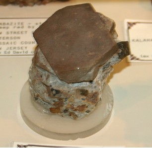
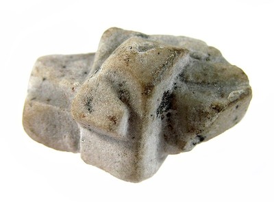
| Species: | Topaz |
| Formula: | Al2(SiO4)(F,OH)2 |
| Comments: | pseudomorphs after carlsbad twin feldspar |
| Confirmation |
|---|
|
| Validity: | Believed Valid |
| Associated Minerals Based on Photo Data: |
|---|
|
| Orthoclase | 6 photos of Topaz associated with Orthoclase at this locality. |
| Quartz | ⓘ4 photos of Topaz associated with Quartz at this locality. |
| Data |
|---|
|
| Mineral Data: | Click here to view Topaz data |
| Locality Data: | Click here to view Saubachriss, Muldenberg, Grünbach, Falkenstein, Vogtlandkreis, Saxony, Germany |
| Photo Gallery | View Gallery (14 photos) |
| Data Identifiers |
|---|
|
| Mindat Occurrence Record ID: | 812735 |
| Long-form Identifier: | 1:3:812735:8 |
| GUID (UUID V4): | 94e7aa1f-7541-4b91-9b5e-95d203477dee |
| Nearest other occurrences of Topaz |
|---|
|
|
| 2.1km (1.3 miles) | ⓘSchneckenstein cliff (Königskrone Topaz Mine), Schneckenstein, Tannenbergsthal, Muldenhammer, Vogtlandkreis, Saxony, Germany |
| 2.8km (1.7 miles) | ⓘTannenberg Mine (Shaft 176), Schneckenstein, Tannenbergsthal, Muldenhammer, Vogtlandkreis, Saxony, Germany |
| 5.0km (3.1 miles) | ⓘGottesberg, Tannenbergsthal, Muldenhammer, Vogtlandkreis, Saxony, Germany |
| 15.5km (9.6 miles) | ⓘRolava-Jeleni (Hirschenstand), Přebuz, Sokolov District, Karlovy Vary Region, Czech Republic |
| 19.9km (12.3 miles) | ⓘFahsel quarry, Blauenthal, Eibenstock, Erzgebirgskreis, Saxony, Germany |
| 20.9km (13.0 miles) | ⓘSchaar Shaft, Johanngeorgenstadt, Erzgebirgskreis, Saxony, Germany |
| 25.9km (16.1 miles) | ⓘPodlesí stock, Potůčky Deposit, Potůčky, Karlovy Vary District, Karlovy Vary Region, Czech Republic |
| 27.5km (17.1 miles) | ⓘGöltzsch river alluvials, Mylau, Reichenbach im Vogtland, Vogtlandkreis, Saxony, Germany |
| 28.8km (17.9 miles) | ⓘMaurizi Mine (St. Maurizius shaft; Mauritius Mine; Beer Mine), Hřebečná, Abertamy, Karlovy Vary District, Karlovy Vary Region, Czech Republic |
| 36.6km (22.8 miles) | ⓘKrudum granite body, Třídomí, Horní Slavkov, Sokolov District, Karlovy Vary Region, Czech Republic |
| References |
|---|
|
|


Saubachriss, Muldenberg, Grünbach, Falkenstein, Vogtlandkreis, Saxony, Germany