|
USA | |
|
| Winchell, Alexander Newton (1914) Mining districts of the Dillon quadrangle, Montana, and adjacent areas. Bulletin Vol. 574. US Geological Survey doi:10.3133/b574
Rocks & Minerals 81:340-355 |
|
| Rocks & Minerals 81:340-355 |
|
| www.mineralnews.com (2002) http://www.mineralnews.com/MinNews/MN18-2.html |
|
| Myers, W. Bradley (1952) Geology and mineral deposits of the northwest quarter of Willis quadrangle and adjacent Browns Lake area, Beaverhead County, Montana. USGS Open File Report 52-105. |
|
| Myers, W. Bradley (1952) Geology and mineral deposits of the northwest quarter of Willis quadrangle and adjacent Browns Lake area, Beaverhead County, Montana. USGS Open File Report 52-105.
Ref: Montana Bureau of Mines and Gology Special Publication 75, 1977 |
|
| Winchell, Alexander Newton (1914) Mining districts of the Dillon quadrangle, Montana, and adjacent areas. Bulletin Vol. 574. US Geological Survey doi:10.3133/b574 |
|
| Winchell, Alexander Newton (1914) Mining districts of the Dillon quadrangle, Montana, and adjacent areas. Bulletin Vol. 574. US Geological Survey doi:10.3133/b574
Ref: Montana Bureau of Mines and Gology Special Publication 75, 1977 |
|
| Winchell, Alexander Newton (1914) Mining districts of the Dillon quadrangle, Montana, and adjacent areas. Bulletin Vol. 574. US Geological Survey doi:10.3133/b574 |
- Blue Wing Mining District
| Gobla, Michael J. (2012) Montana Mineral Locality Index. Rocks & Minerals, 87 (3) 208-240 doi:10.1080/00357529.2012.676825 |
|
| Rocks & Minerals 81:340-355 |
|
| Winchell, Alexander Newton (1914) Mining districts of the Dillon quadrangle, Montana, and adjacent areas. Bulletin Vol. 574. US Geological Survey doi:10.3133/b574 |
|
| Ref: Montana Bureau of Mines and Gology Special Publication 75, 1977 |
|
| Thorne, Brent (n.d.) Personal communcation. |
|
| Winchell, Alexander Newton (1914) Mining districts of the Dillon quadrangle, Montana, and adjacent areas. Bulletin Vol. 574. US Geological Survey doi:10.3133/b574
Karlstrom, MBMG Memoir No. 25, Pp 50-51 |
|
| Karlstrom, TNV MBMG Memoir No.25 |
|
| Gobla, Michael J. (2012) Montana Mineral Locality Index. Rocks & Minerals, 87 (3) 208-240 doi:10.1080/00357529.2012.676825 |
|
| Gobla, Michael J. (2012) Montana Mineral Locality Index. Rocks & Minerals, 87 (3) 208-240 doi:10.1080/00357529.2012.676825 |
- Elkhorn Mining District (Coolidge Mining District; Wise River Mining District)
| Rocks & Minerals 81:340-355 |
|
| Winchell, Alexander Newton (1914) Mining districts of the Dillon quadrangle, Montana, and adjacent areas. Bulletin Vol. 574. US Geological Survey doi:10.3133/b574 |
|
| Winchell, Alexander Newton (1914) Mining districts of the Dillon quadrangle, Montana, and adjacent areas. Bulletin Vol. 574. US Geological Survey doi:10.3133/b574 |
|
| (2005) Mineral Resources Data System (MRDS), US Geological Survey. |
- Radersburg Mining District (Cedar Plains Mining District; Lone Mountain Mining District)
| Gobla, Michael J. (2012) Montana Mineral Locality Index. Rocks & Minerals, 87 (3) 208-240 doi:10.1080/00357529.2012.676825 |
|
| Winchell, Alexander Newton (1914) Mining districts of the Dillon quadrangle, Montana, and adjacent areas. Bulletin Vol. 574. US Geological Survey doi:10.3133/b574 |
|
| Ref: Montana Bureau of Mines and Gology Special Publication 75, 1977 |
|
| Chris Tucker |
|
| Winchell, Alexander Newton (1914) Mining districts of the Dillon quadrangle, Montana, and adjacent areas. Bulletin Vol. 574. US Geological Survey doi:10.3133/b574
Chris Tucker |
|
| www.christuckerminerals.com and Chris Tucker Collection |
|
| Ref: Montana Bureau of Mines and Gology Special Publication 75, 1977 |
|
| Gobla, Michael J. (2012) Montana Mineral Locality Index. Rocks & Minerals, 87 (3) 208-240 doi:10.1080/00357529.2012.676825 |
|
| Gobla, Michael J. (2012) Montana Mineral Locality Index. Rocks & Minerals, 87 (3) 208-240 doi:10.1080/00357529.2012.676825 |
|
| www.christuckerminerals.com
USGS Bull 1042N |
- Neihart Mining District (Montana Mining District)
| Gobla, Michael J. (2012) Montana Mineral Locality Index. Rocks & Minerals, 87 (3) 208-240 doi:10.1080/00357529.2012.676825 |
- Blue Eyed Nellie Mining District
| Mines and Mineral Deposits of the Southern Flint Creek Range, Montana
F.N.Earll, March 1972 |
|
| Gobla, Michael J. (2012) Montana Mineral Locality Index. Rocks & Minerals, 87 (3) 208-240 doi:10.1080/00357529.2012.676825 |
- Dunkleberg Mining District
| (2005) Mineral Resources Data System (MRDS), US Geological Survey. |
- Philipsburg Mining District (Flint Creek Mining District)
| Gobla, Michael J. (2012) Montana Mineral Locality Index. Rocks & Minerals, 87 (3) 208-240 doi:10.1080/00357529.2012.676825
Waisman, Dave (1992) Minerals of the Black Pine Mine, Granite County, Montana. The Mineralogical Record, 23 (6) 477-483 |
|
| Min News 21:7 p 1,3, 4 |
|
| Gobla, Michael J. (2012) Montana Mineral Locality Index. Rocks & Minerals, 87 (3) 208-240 doi:10.1080/00357529.2012.676825 |
|
| Geology and Ore Deposits of the Philipsburg District, Granite Co., Montana
William C. Prinz, 1967 |
- South Boulder Creek Mining District (Princeton Mining District)
| Min News 20:6 pp11-12 |
- Cataract Mining District (Comet Mining District; Basin Mining District)
| (2005) Mineral Resources Data System (MRDS), US Geological Survey. |
|
| Gobla, Michael J. (2012) Montana Mineral Locality Index. Rocks & Minerals, 87 (3) 208-240 doi:10.1080/00357529.2012.676825
William C. van Laer. |
|
| Geology and Ore Deposits of the Elkhorn Mining District, Jefferson County, Montana
Walter H. Weed, 1900-1901
Rocks & Minerals 83:1 pp 20-33 |
|
| Koschmann, Albert Herbert, Bergendahl, M.H. (1968) Principal gold-producing districts of the United States. Professional Paper 610. US Geological Survey doi:10.3133/pp610 |
|
| Witkind, I. J., (1973)
Igneous Rocks and Related Mineral Deposits of the Barker Quadrangle, Little Belt Mountains, Montana: U.S. Geological Survey Prof. Paper 752, 58 P. |
|
| Gobla, Michael J. (2012) Montana Mineral Locality Index. Rocks & Minerals, 87 (3) 208-240 doi:10.1080/00357529.2012.676825
Chris Tucker and John Betts specimens. |
- Blue Cloud Mining District
| Gobla, Michael J. (2012) Montana Mineral Locality Index. Rocks & Minerals, 87 (3) 208-240 doi:10.1080/00357529.2012.676825
Chris Tucker and John Betts specimens. |
- Marysville Mining District
| Gobla, Michael J. (2012) Montana Mineral Locality Index. Rocks & Minerals, 87 (3) 208-240 doi:10.1080/00357529.2012.676825
Chris Tucker and John Betts specimens. |
|
| Gobla, Michael J. (2012) Montana Mineral Locality Index. Rocks & Minerals, 87 (3) 208-240 doi:10.1080/00357529.2012.676825
Chris Tucker and John Betts specimens. |
- Sevenmile-Scratchgravel Mining District
| Gobla, Michael J. (2012) Montana Mineral Locality Index. Rocks & Minerals, 87 (3) 208-240 doi:10.1080/00357529.2012.676825
Chris Tucker and John Betts specimens. |
|
| Stewart, D. B. (1959) Narsarsukite from Sage Creek, Sweetgrass Hills, Montana. American Mineralogist, 44 (3-4) 265-273 |
|
| Gobla, Michael J. (2012) Montana Mineral Locality Index. Rocks & Minerals, 87 (3) 208-240 doi:10.1080/00357529.2012.676825 |
- Lower Hot Springs Mining District (Norris Mining District)
| Winchell, Alexander Newton (1914) Mining districts of the Dillon quadrangle, Montana, and adjacent areas. Bulletin Vol. 574. US Geological Survey doi:10.3133/b574 |
- Mineral Hill Mining District (Pony Mining District)
| MBMG IC-24(Reid,1958) |
- Rochester Mining District (Rabbit Mining District)
| Gabe Cangelosi Collection |
|
| Winchell, Alexander Newton (1914) Mining districts of the Dillon quadrangle, Montana, and adjacent areas. Bulletin Vol. 574. US Geological Survey doi:10.3133/b574 |
|
| Winchell, Alexander Newton (1914) Mining districts of the Dillon quadrangle, Montana, and adjacent areas. Bulletin Vol. 574. US Geological Survey doi:10.3133/b574 |
|
| Museum of Natural History, Roger Williams Park, Prov., RI G4708 6931 |
|
| Winchell, Alexander Newton (1914) Mining districts of the Dillon quadrangle, Montana, and adjacent areas. Bulletin Vol. 574. US Geological Survey doi:10.3133/b574 |
|
| Dana 6:791. |
|
| Dana 6: 791. |
- Tidal Wave Mining District
| Winchell, Alexander Newton (1914) Mining districts of the Dillon quadrangle, Montana, and adjacent areas. Bulletin Vol. 574. US Geological Survey doi:10.3133/b574 |
|
| Winchell, Alexander Newton (1914) Mining districts of the Dillon quadrangle, Montana, and adjacent areas. Bulletin Vol. 574. US Geological Survey doi:10.3133/b574 |
|
| Winchell, Alexander Newton (1914) Mining districts of the Dillon quadrangle, Montana, and adjacent areas. Bulletin Vol. 574. US Geological Survey doi:10.3133/b574 |
|
| USGS Bull 139 |
|
| USGS Bull 139 |
|
| USGS Bull 139 |
|
| USGS Bull 139 |
|
| Gobla, Michael J. (2012) Montana Mineral Locality Index. Rocks & Minerals, 87 (3) 208-240 doi:10.1080/00357529.2012.676825 |
|
| USGS Bull 139 |
- Packer Creek Mining District
| Gobla, Michael J. (2012) Montana Mineral Locality Index. Rocks & Minerals, 87 (3) 208-240 doi:10.1080/00357529.2012.676825 |
|
| A specimen in the G.J.Bursh collection at Yale University. See cerussite gallery. |
- Pioneer Mining District (Gold Creek Mining District)
| Lanny Ream (2007) "Gold & wulfenite on South Gold Creek, Flint Creek Range, Montana". Mineral News, 23, #5. |
- Zosell Mining District (Emery Mining District)
| USGS Bulletin 842 |
|
| USGS Bulletin 842 |
|
| Gobla, Michael J. (2012) Montana Mineral Locality Index. Rocks & Minerals, 87 (3) 208-240 doi:10.1080/00357529.2012.676825 |
|
| Gobla, Michael J. (2012) Montana Mineral Locality Index. Rocks & Minerals, 87 (3) 208-240 doi:10.1080/00357529.2012.676825 |
- Thompson River Mining District
| Gobla, Michael J. (2012) Montana Mineral Locality Index. Rocks & Minerals, 87 (3) 208-240 doi:10.1080/00357529.2012.676825
ace.acadiau.ca (n.d.) http://ace.acadiau.ca/~cstanley/Research/Past/Journals/CRS_1987.htm. |
- Butte Mining District (Summit Valley Mining District)
| Mineralogical Record 33:1 |
|
| Singer, D.A., Berger, V.I., Moring, B.C. (2008) Porphyry copper deposits of the world: Database and grade and tonnage models, 2008. Open-File Report 2008-1155 |
|
| Gammons, C. H., Szarkowski, J., & Stevenson, R. (2016) New investigations of the mineralogy of silver in the world-class porphyry-lode deposits of Butte, MT. Mining engineering Magazine website
Mineralogical Record 33:1
Anaconda Mining Company Collection |
|
| Zeihen, Lester G. and Guilbert, John M. (1964). The Mineralogy of the Butte District, Montana
Pg14, Table 7-2, Oxidation of the Peripheral Zone mineralogy summary. |
|
| Winchell, Alexander Newton (1914) Mining districts of the Dillon quadrangle, Montana, and adjacent areas. Bulletin Vol. 574. US Geological Survey doi:10.3133/b574 |


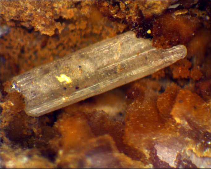


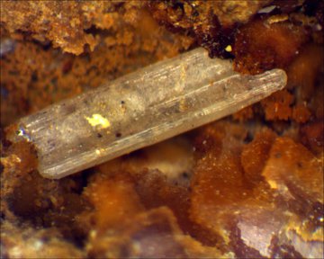


Keystone Mine, Missoula County, Montana, USA