 | | Journal (article/letter/editorial) | | Houston, Texas 77036 ROBERT 0. FAY Oklahoma Geological Survey Norman, Oklahoma 73019 Downloaded by [The Aga...713 15th Street NW Ardmore, Oklahoma 73401 OKLAHOMA Figure 1. Oklahoma counties. Mineral Locality...known for its gypsum crystals and barite roses, Oklahoma also boasts a variety of other species, including...unaware of the variety of minerals available from Oklahoma and think primarily of the prolific gypsum crystals...hundred years, extends into the northeast corner of Oklahoma and has produced notable specimens. Unfortunately | 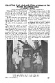 | | Journal (article/letter/editorial) | | COLLECTING ZINC, LEAD AND OTHER MINERALS IN THE PICHER, OKLAHOMA AREA By GARDINER E. GREGORY Director: The...states. We enjoyed excellent collecting in the Picher, Oklahoma ar~a. . My wI~e Anne and 1 were accompanied...trailer, and the Romalewski' s tented out. The Picher area contains a zinc-lead deposit, which also extends...drilling near Commerce, Oklahoma. By 1916 large scale operations existed in the Picher Field. The decline or...meteoric rise of the Picher Field. The largest mining company in the area is the Eagle-Picher Corporation, who |  | | Journal (article/letter/editorial) | | figure 2 (leftI: Galena. Crawford mine, Pirher, Oklahoma, Tri-State district; 6' 2 cm across; Harvard Mineralogical...of the 1970s. The last remaining operator, Eagle-Picher Indus tries, closed the Bear Hole mine in February...of the Crescent Formation, Robertson Pit, Mason County, Washington" (January/February 1988). From 1961...open Figure 10: Shullsburg mine and mill, Eagle-Picher Co., Shullsburg, Wisconsin, Upper Mississippi Valley...in Pope County, and the Rosiclare, Cave in Rock, and Harris Creek districts in Hardin County. Significant |  | | Journal (issue) | | The Tri-State Mining District Missouri-Kansas-Oklahoma by Denise Bicknell Wendell E. Wilson 2017 The...Tucson USA Visit us at these international shows: Houston Ste. Marie Denver Munich USA France USA Germany...and Riverpark Inn Rhodochrosite, Sweet Home Mine, USA, 10 cm Photo: Malte Sickinger MARCUS BUDIL Monaco... The Tri-State Mining District Missouri-Kansas-Oklahoma Denise Bicknell 16711 East Whimbrel Circle Conroe...settled Tri-State area of Missouri, Kansas, and Oklahoma suspected the world of wealth that lay just beneath |  | | Report (issue) | | Geology and Ore Deposits of the Picher Field Oklahoma and Kansas GEOLOGICAL SURVEY PROFESSIONAL PAPER... 588 Geology and Ore Deposits of the Picher Field Oklahoma and Kansas By EDWIN T. McKNIGHT and RICHARD...towns and mine workings in the main part of the Picher field. Geologic map of the Wyandotte quadrangle. Isopach...bed and approximate west limit of L bed in the Picher field. Sections and correlation of the Moccasin Bend...and dolomitized areas in part of the Picher zinc-lead field, Oklahoma and Kansas: 5. Northwest sheet. 6 |  | | Journal (article/letter/editorial) | | the world. These are the Tri-State district of Oklahoma, Kansas, and Missouri and the world-class Viburnum...from southwestern Missouri through Kansas into Oklahoma (fig. l), was one of the primary zinc-producing...titled “Minerals of the Vanadinite Mine, Mohave County, Arizona.” 400 ROCKS 81 MINERALS rized in Lasnianis...Mining did not start in Kansas until 1877 and in Oklahoma until 1891. In 1853 lead mining began at Granby...the Granby Mining and Smelting Company. In Jasper County, a large lead deposit was discovered by J. B. Sargent |  | | Report (volume) | | constitute ores. In the San Rafael Swell area, Emery County, Utah, and particularly at Temple Mountain within... Minnesota, Missouri, Nebraska, North Dakota, Oklahoma, South Dakota, and Texas: Geol. Soc. America Bull...Devil No. 6 deposit [San Rafael Swell area, Emery County, Utah] had 0.105 percent uranium in two hydrocarbons...the lower Permian dolomites of the Panhandle gas field, Texas, and in dolomites of the Seven Rivers gypsiferous...obtained from the Sun field, Starr County, Tex.; Navarro Crossing, Navarro County, Tex.; and the Fitts |  | | Journal (issue) | | Other treasures he acquired include azurite and malachite from the Cobar region, zeolites from Richmond...Trust Tourmaline, 10 cm, from the Malkhan pegmatite field, Krasnyi Chikoy, Chitinskaya Oblast, Zabaykalski...from the British mine, Broken Hill, Yancowinna County, New South Wales, Australia. Tourmaline, 10 cm...(spodumene), 11 cm, from the Pala Chief mine, San Diego County, California. Tourmaline, 11 cm, from the Santa...crystals on matrix, 10 cm, from the Amo mine, Ximeng County, Yunnan Province, China. Barite on dolomite, 12 |  | | Journal (issue) | | Kunzite-Gary and Rosemany White collection, page 295; Malachite-Don and Laura Aaron collection, page 11. (rniddle...204; Cerussite-Joe Budd collection, page 63; Malachite-Tim & Holly Smith collection, page 244. (right...in the Gien Rose Limestone formation of Lampasas County. Lampasas celestine first became well known among... HI STORY_....,_ _ _ _ _ _ _ _ _ _......., J COUNTY MAp o, '1~AAa M'Al.t.OFM.11.ES An 1870 map of...Barber's Hili salt dome at Mont Belview, Chambers County, on the Texas Gulf coast, small but sharp tetrahedral |  | | Report (issue) | | International, LLC P.O. Box 263, East Hampton, CT 06424, USA Phone 1.860.267.1512; fax 1.860.267.7225 www.lapisint...at the Crystal River quarry, Lecanto in Citrus County Florida. Collection Francis Benjamin; photo Jeff...twin on {1 OTI} from the Leiping mine, Guiyang County, Hunan, China. Collection Frederic Escaut; photo...(0001} from St. Clair Lime quarry, Sequoyah County, Oklahoma. Collection Terry Huizing; photo Jeff Scovil...lower left: 6.2 cm high specimen of calcite and malachite from Morocco. Collection Victor Yount; photo Jeff |  | Gemmell, J. Bruce, Simmons, Stuart F., Zantop, Half (1988) The Santo Nino silver-lead-zinc vein, Fresnillo District, Zacatecas, Mexico; Part I, Structure, vein stratigraphy, and mineralogy. Economic Geology, 83 (8) 1597-1618 doi:10.2113/gsecongeo.83.8.1597 | Journal (article/letter/editorial) | | Oxidizedfracturescontainlimonite,hematite,Mn oxide,malachite, azurite,andnativesilver.Ganguemineralsincludequartz...structuraland stratigraphiccontrolsof vein development. Field work was conducted during four months in 1984 and...dicatesthat the Chilitos Formationis youngerthan Personal field observations and discussions with previouslythought...claysre- supergenelimonite, hematite,Mn oxide, malachite, placingfeldspar.Theseminorgeochemical variations...molepercentFeS in sphaleritecoincideswith the pyrrhotite field boundary.Quartz is present throughoutthe diagram |  | | Report (issue) | | ......................... Tri-State district, Oklahoma, Kansas, and Missouri ..........................jasperoid-bearing areas in 36. Southwest Missouri, Oklahoma, Kansas, and Arkansas ..........................West) surrounding the common corner of Kansas, Oklahoma, and Missouri, and (6) the lead-zinc "district"...example, Ely, Nev., Leadville, Colo., and the "Picher Field," Okla. 4 JASPEROID IN THE UNITED STATES...example, in the Tri-State district of Kansas, Oklahoma, and Missouri. GEOLOGIC AGE The laboratory methods |  | | Journal (issue) | | Vanadinite 3.4 cm, from the North Geronimo mine, La Paz County, Arizona. Dick Morris collection; Jeff Scovil photo...copper-containing minerals (e.g., chalcopyrite, azurite, malachite, chrysocolla, linarite, etc.). Consequently it...their Air Force career, we took the opportunity to field-collect minerals there. In fact, my mother, who...cm, from the Defiance mine near Gleeson, Cochise County, Arizona. Ken Donn photo. 6 Supplement to The...2.3 cm, from the Breckenridge district, Summit County, Colorado. Ken Donn photo. Wulfenite (hot-pink) |  | Kettanah, Yawooz, Zentilli, Marcos, Hanley, Jacob, Tweedale, Fergus (2016) Geological setting and fluid inclusion characteristics of a lead-copper-barium occurrence hosted in a Neoproterozoic mafic sill at Kiatak, Northumberland Island, Northwestern Greenland. Ore Geology Reviews, 79. 268-287 doi:10.1016/j.oregeorev.2016.05.027 | Journal (article/letter/editorial) | | elongated in an SW-NE direction (Fig. 2). In the field, the mineralization is noticeable because of the...barite, as well as galena crystals, and localized malachite. The mineralization SC occupies fractures and...10 m to more than 200 m in width. During brief field work in 2001 it was observed that the dike intersects...sill locality labelled Na-13 A to X. Preliminary field observation appeared to indicate that the diabase...Saint Mary’s University, using a TESCAN MIRA3 LM field emission SEM equipped with an LN2-free Oxford X-Max |  | | Journal (issue) | | topographical or systGmatic mineralogy or for work in the field of \:onservation of mineralogical sites or materials... Also, in many lowland counties of England the County Plans give details of proposed mineral extraction...2, the county of Shropshire was incorrectly referred to throughout as Salop. In the 1974 county reorganisations...indeed renamed Salop (the old Latin name for the county), but the name was changed back to Shropshire in...revolutionary innovation which has transformed the field of chemical analysis, particularly in metallurgical |  | | Report (volume) | | maps included. Subject. .Subject. Areas covered by field trips. History of various organizations or geological...mineralogic, paleontologic, etc. Listed by name of field. Subject and area. Subject and area. Subject and...Gems and gem materials. Cunacla, Baffin Island ': Field. D. S. M. 3 Emerald, absorption spectrum : .A-oclerson...rather than indexed separately. The San Ardo oil field is not found under S, but in its proper alphabetical...series. Ottawa. Canada Dominion Observatory Pubs. Canada r»ominion Observatory Publica- tions. Ottawa. Canada |  | | Report (volume) | | cientlfica Circular Classe classification Company, County Collections Committee Communications Comparative...Canada Bureau of Mines Memorandum Series 90, 91. Ottawa, Canada. Canada Department of Mines and Resources...Annual Reports, years ending 3/31/45 and 3/31/46. Ottawa, Canada. Canada'Geological Survey: Bulletin nos...47-1. Ottawa, Canada. Canadian Alpine Journal vols. 29, no. 2; 30. Banff, Alberta.Canadian Field-Naturalist...Field-Naturalist vols. 59, nos. 5, 6; 60; 61. Ottawa, Canada. Canadian Geographical Journal vols. 32-35. Montreal |  | Amstutz, G. C., Goresy, A. El, Frenzel, G., Kluth, C., Moh, G., Wauschkuhn, A., Zimmermann, R.A. - Eds. (1982) Ore Genesis. Springer Berlin, Heidelberg. doi:10.1007/978-3-642-68344-2 | Book | | have undergone a decisive shift, not only in our field of research but also in many neighboring natural...the Tri-State District of Missouri, Kansas, and Oklahoma, U.S.A. R.D. Hagni (With 6 Figures) . . . . ....balance ores are concentrated only within the ore field of the "Conrad" Mine (Konstantinovich 1972; Narkelun...conglomerate sequence. To the east and south of the ore field of the "Conrad" Mine, the "cop- 12 Yu.V. Bogdanov...times greater than that of the Dzhezkazgan ore field. Thus, the largest copper deposits of Poland, no |  | | Report (issue) | | Survey Division North Dakota Geological Survey Oklahoma Geological Survey South Dakota Geological Survey...representing the Executive Director of St. Louis County 8:30 An introduction to the research programs of...evaluation of the Pea Ridge iron ore mine (Washington County, Missouri) for rare earth and precious metal potential...microscopy of the Paoli silver-copper deposit, Oklahoma -- Craig A. Thomas, Richard D. Hagni, and Pieter...located in sec. 31, T. 5 S., R. 5 E. in Washington County, Kansas, was drilled to a depth of 11,300 feet |  | | Report (issue) | | Sutvey Division North Dakota Geological Sutvey Oklahoma Geological Sutvey South Dakota Geological Sutvey...representing the Executive Director of St. Louis County 8:30a.m. An introduction to the research programs...evaluation of the Pea Ridge iron ore mine (Washington County, Missouri) for rare-earth element and precious...project of the Pea Ridge iron ore deposit, Washington County, Missouri Laurence M. Nuelle, Cheryl M. Seeger...microscopy of the Paoli silver-copper deposit, Oklahoma Craig A. Thomas, Richard D. Pieter Berendsen Missouri's |  | | Book | | by the author over a period of 40 years on many field trips, visits to mines and expeditions in many parts...metallic elements in the Bereich of the granitization field and on the lateral or mobilization of elements peripheral...mineral will prevail or survive depends on the field of stability of each crystallization, on the reactions...geoenvironmental conditions prevail in the petrogenetic "field" (Bereich) of metallic elements derivation. (i)...metamorphic-metasomatic differentiations in the field of metamorphism-granitization. The fact that the |  | | Report (volume) | | mapping by airborne infrared imagery techniques: Oklahoma Acad. Sci. Proc. 1970, v. 50,p. l0-18,illus.,...alternating field method and new paleointensity measurements of the Miocene geomagnetic field in Oregon:... Shunsuke. Determination of underground stress field based on inelastic properties of rocks, Chap. 18... A. A. Crystallography of ice on Knob Lake, in Field research in Labrador-Ungava [1965-66]: McGTII Univ...Adams, W. P. (editor). Ten years (1954-1964) of field research in Labrador-Ungava: McGill Univ. Dept. |  | | Report (issue) | | sulfide deposits in differentiated volcanic rocks--a field guide, by. R. L. Earhart..........................tholeiitic lavas of Munro Township, Ontario: Their field, petrographic and chemical characteristics. Jour...found in folded and thrusted areas such as in Pike County, Arkansas. Locally they are found as clusters of...20 7 150 70 10 70 100 1 10 not analysed Elliot County, Kentucky, main Kimberlite pipe body, whole rock...Brookins, D. G., 1970, The Kimberlites of Riley County, Kansas: Kansas Geological Survey Bulletin 200 |  | | Report (volume) | | Resources, Inland Waters Branch Technical Bulletin. Ottawa, Ontario, Canada. Canada Dept. Energy, Mines and...and Resources, Mines Branch Information Circular. Ottawa, Ontario, Canada. Canada Geol. Survey Bull. Canada...Canada. Geological Survey of Canada Bulletin. Ottawa, Ontario, Canada Geol. Survey Econ. Geology Rept...Geology Report. Ottawa, Ontario, Canada. Canada Geol. Survey Geophysics Paper Paper. Ottawa, Ontario, Canada...Canada Map. Ottawa, Ontario, Canada Geol. Survey Mem.- Geological Survey of Canada Memoir. Ottawa, Ontario |  | | Report (volume) | | aspects of Lower Morrow sandstones, northwestern Oklahoma [abs] Shale Shaker, v 14, no 2, p 9, 1963 7980...[V 111-Natl Conf Clays and Clay Mmerals, lith, Ottawa, 1962, Proc New York, Macmtllan Co (lnternat Ser...sectwn of Paleozotc rocks from Butler County to Stafford County, Kansas Kansas Geol Survey Otl and Gas...cross section from Barber County, Kansas, to Caddo County, Oklahoma Oklahoma Geol Survey Gutdebook 13...Desmomestan rocks m the Arkoma Bas10 of east-central Oklahoma· Jour Sed Petrology, v 33, no 2, p 393-410, tllus |
|


