| Locality type: | Mine |
| Classification |
|---|
|
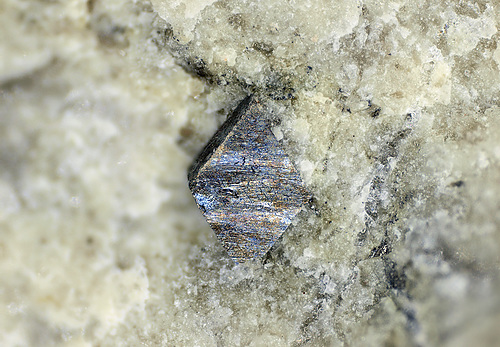
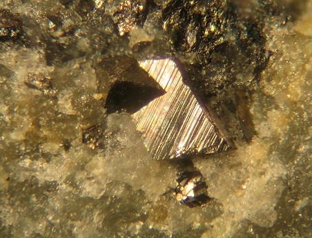
| Species: | Arsenopyrite |
| Formula: | FeAsS |
| Confirmation |
|---|
|
| Validity: | Believed Valid |
| Associated Minerals Based on Photo Data: |
|---|
|
| Mimetite | ⓘ1 photo of Arsenopyrite associated with Mimetite at this locality. |
| Data |
|---|
|
| Mineral Data: | Click here to view Arsenopyrite data |
| Locality Data: | Click here to view Ste Barbe vein (Les Montmins), Montmins mining district, Échassières, Vichy, Allier, Auvergne-Rhône-Alpes, France |
| Photo Gallery | View Gallery (11 photos) |
| Data Identifiers |
|---|
|
| Mindat Occurrence Record ID: | 162830 |
| Long-form Identifier: | 1:3:162830:2 |
| GUID (UUID V4): | 7a59d7a9-32f0-4a18-828d-06946b6d674b |
| Nearest other occurrences of Arsenopyrite |
|---|
|
|
| 0.4km (0.2 miles) | ⓘLe Mazet vein, Le Mazet, Montmins mining district, Échassières, Vichy, Allier, Auvergne-Rhône-Alpes, France |
| 2.3km (1.4 miles) | ⓘBeauvoir quarry, Échassières, Vichy, Allier, Auvergne-Rhône-Alpes, France |
| 4.6km (2.9 miles) | ⓘBois du Roi, Les Chaillats (Chaillat), Servant, Riom, Puy-de-Dôme, Auvergne-Rhône-Alpes, France |
| 4.8km (3.0 miles) | ⓘPuits Giraudet, Nades mines, Nades, Vichy, Allier, Auvergne-Rhône-Alpes, France |
| 19.4km (12.0 miles) | ⓘLes Méritis, Blot-l'Église, Riom, Puy-de-Dôme, Auvergne-Rhône-Alpes, France |
| 26.7km (16.6 miles) | ⓘGrand Etang alluvial deposits, Andelot River watershed, Saint-Didier-la-Forêt, Vichy, Allier, Auvergne-Rhône-Alpes, France |
| 31.7km (19.7 miles) | ⓘMontmalard, Bresnay, Moulins, Allier, Auvergne-Rhône-Alpes, France |
| 38.0km (23.6 miles) | ⓘLe Châtelet mine, Budelière, Aubusson, Creuse, Nouvelle-Aquitaine, France |
| 38.8km (24.1 miles) | ⓘPranal, Bromont-Lamothe, Riom, Puy-de-Dôme, Auvergne-Rhône-Alpes, France |
| 46.2km (28.7 miles) | ⓘVilleranges mine, Lussat, Aubusson, Creuse, Nouvelle-Aquitaine, France |
| References |
|---|
|
Cuchet, Stéphane, Brugger, Joël, Ansermet, Stefan, Chiappero, Pierre-Jaques (2000) Les minéraux du filon Sainte-Barbe, Les Montmins, Allier, (France) [The minerals of the Sainte-Barbe vein, Les Montmins, Allier, (France)]. Le Règne Minéral, 6 (33) 5-25 |


Ste Barbe vein, Montmins mining district, Échassières, Vichy, Allier, Auvergne-Rhône-Alpes, France