| Locality type: | Mine |
| Classification |
|---|
|
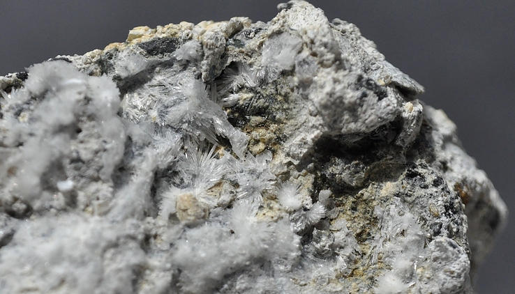
| Species: | Picropharmacolite |
| Formula: | Ca4Mg(AsO4)2(HAsO4)2 · 11H2O |
| Confirmation |
|---|
|
| Validity: | Believed Valid |
| Data |
|---|
|
| Mineral Data: | Click here to view Picropharmacolite data |
| Locality Data: | Click here to view Shaft 371, Hartenstein, Zwickau District, Saxony, Germany |
| Photo Gallery | View Gallery (2 photos) |
| Data Identifiers |
|---|
|
| Mindat Occurrence Record ID: | 143053 |
| Long-form Identifier: | 1:3:143053:0 |
| GUID (UUID V4): | 68f1a152-f170-4a37-8034-1e2200677b8b |
| Nearest other occurrences of Picropharmacolite |
|---|
|
|
| 1.8km (1.1 miles) | ⓘShaft 296 (dump), Alberoda, Aue-Bad Schlema, Erzgebirgskreis, Saxony, Germany |
| 2.2km (1.4 miles) | ⓘShaft 186, Alberoda, Aue-Bad Schlema, Erzgebirgskreis, Saxony, Germany |
| 2.3km (1.5 miles) | ⓘShaft 38, Niederschlema, Bad Schlema, Aue-Bad Schlema, Erzgebirgskreis, Saxony, Germany |
| 7.6km (4.7 miles) | ⓘDaniel Mine (St. Daniel Mine), Neustädtel, Schneeberg, Erzgebirgskreis, Saxony, Germany |
| 13.4km (8.3 miles) | ⓘGraul, Langenberg, Raschau-Markersbach, Erzgebirgskreis, Saxony, Germany |
| 13.9km (8.7 miles) | ⓘGottes Geschick Mine, Gottes Geschick Vereinigt Feld Mine, Graul, Langenberg, Raschau-Markersbach, Erzgebirgskreis, Saxony, Germany |
| 15.4km (9.5 miles) | ⓘShaft 235, Antonsthal, Breitenbrunn, Erzgebirgskreis, Saxony, Germany |
| 15.6km (9.7 miles) | ⓘShaft 318, Erla-Crandorf, Schwarzenberg, Erzgebirgskreis, Saxony, Germany |
| 15.8km (9.8 miles) | ⓘShaft 306, Erla-Crandorf, Schwarzenberg, Erzgebirgskreis, Saxony, Germany |
| 24.0km (14.9 miles) | ⓘUranus Mine, Kleinrückerswalde, Annaberg-Buchholz, Erzgebirgskreis, Saxony, Germany |
| References |
|---|
|
|
| Reference Search (possible matching items) |
|---|
 | | Book | | Mount Malosa, Chilwa alkaline province, Zomba district. "Illite" is the name of a series of incompletely...of rutile (Weerth, 2004). Tonniq Valley, Skardu district, Gilgit-Baltistan [Northern Areas]. Beginning...testing to be hematite. Zagi [Zegi] Mountain, Warsak district, North West Frontier Province. Surface diggings...to 6 cm (2005: 120). Los Remedios mine, Taxco district, Taxco, Guerrero. Ilvaite occurs in the wallrock...manto deposits of polymetallic ores in the Taxco district, commonly as compact aggregates of crystals overgrown |
|


Shaft 371, Hartenstein, Zwickau District, Saxony, Germany