| Classification |
|---|
|
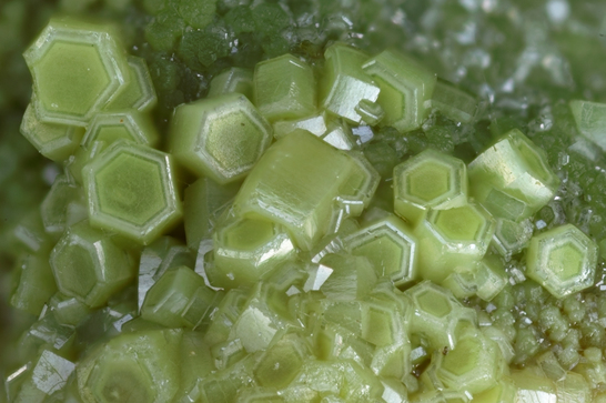
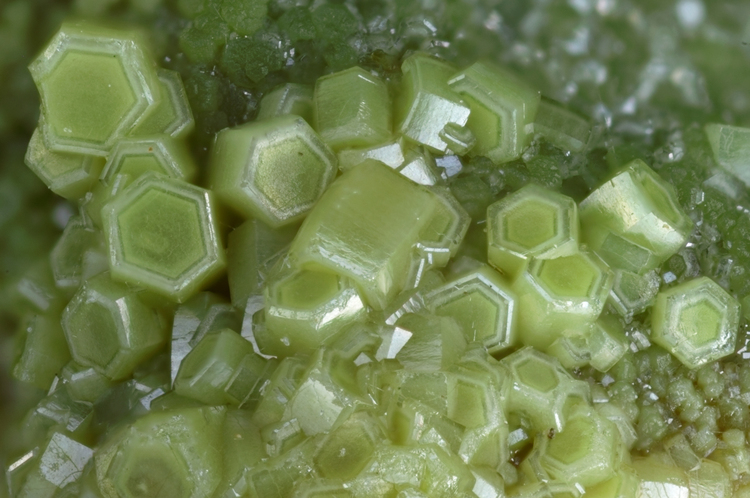
| Species: | Pyromorphite |
| Formula: | Pb5(PO4)3Cl |
| Confirmation |
|---|
|
| Validity: | Confirmed |
| Confirmation Methods: | Visually Identified |
| Associated Minerals Based on Photo Data: |
|---|
|
| Wulfenite | ⓘ8 photos of Pyromorphite associated with Wulfenite at this locality. |
| Plumbogummite | ⓘ2 photos of Pyromorphite associated with Plumbogummite at this locality. |
| Data |
|---|
|
| Mineral Data: | Click here to view Pyromorphite data |
| Locality Data: | Click here to view La Croix des Oncins, Monsols, Deux-Grosnes, Villefranche-sur-Saône, Rhône, Auvergne-Rhône-Alpes, France |
| Photo Gallery | View Gallery (9 photos) |
| Data Identifiers |
|---|
|
| Mindat Occurrence Record ID: | 753161 |
| Long-form Identifier: | 1:3:753161:3 |
| GUID (UUID V4): | 88d51468-49cf-4603-9b03-eadb7dce87f8 |
| Nearest other occurrences of Pyromorphite |
|---|
|
|
| 0.6km (0.3 miles) | ⓘLa Verrière (Montchonay), Les Ardillats, Villefranche-sur-Saône, Rhône, Auvergne-Rhône-Alpes, France |
| 6.4km (4.0 miles) | ⓘCreuzeval Quarry, Saint-Didier-sur-Beaujeu, Villefranche-sur-Saône, Rhône, Auvergne-Rhône-Alpes, France |
| 7.1km (4.4 miles) | ⓘNuizière (Nuissière Mine), Chénelette, Villefranche-sur-Saône, Rhône, Auvergne-Rhône-Alpes, France |
| 7.3km (4.5 miles) | ⓘChanrion mine, Poule-les-Écharmeaux, Villefranche-sur-Saône, Rhône, Auvergne-Rhône-Alpes, France |
| 8.4km (5.2 miles) | ⓘLongefay mine, Poule-les-Écharmeaux, Villefranche-sur-Saône, Rhône, Auvergne-Rhône-Alpes, France |
| 9.5km (5.9 miles) | ⓘMonterniers Mines, Lantignié, Villefranche-sur-Saône, Rhône, Auvergne-Rhône-Alpes, France |
| 50.6km (31.4 miles) | ⓘLes Rats Mine, Le Crozet, Roanne, Loire, Auvergne-Rhône-Alpes, France |
| 54.5km (33.8 miles) | ⓘChâteaumorand and RN7 slope, Saint-Martin-d'Estréaux, Roanne, Loire, Auvergne-Rhône-Alpes, France |
| 59.6km (37.0 miles) | ⓘGrezolette Mine, Saint-Martin-la-Sauveté, Roanne, Loire, Auvergne-Rhône-Alpes, France |
| 59.7km (37.1 miles) | ⓘDurelle Mine, Juré, Saint-Just-en-Chevalet, Roanne, Loire, Auvergne-Rhône-Alpes, France |
| References |
|---|
|
|


La Croix des Oncins, Monsols, Deux-Grosnes, Villefranche-sur-Saône, Rhône, Auvergne-Rhône-Alpes, France