| Locality type: | Vein |
| Classification |
|---|
|
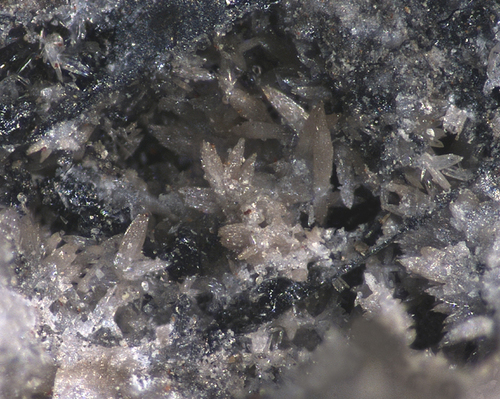
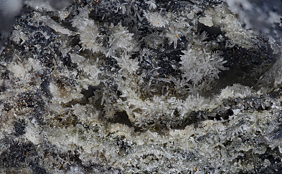
| Species: | Scotlandite |
| Formula: | PbSO3 |
| Confirmation |
|---|
|
| Validity: | Confirmed |
| Confirmation Methods: | Visually Identified |
| Associated Minerals Based on Photo Data: |
|---|
|
| Mattheddleite | ⓘ1 photo of Scotlandite associated with Mattheddleite at this locality. |
| Leadhillite | ⓘ1 photo of Scotlandite associated with Leadhillite at this locality. |
| Caledonite | ⓘ1 photo of Scotlandite associated with Caledonite at this locality. |
| Data |
|---|
|
| Mineral Data: | Click here to view Scotlandite data |
| Locality Data: | Click here to view Scar Vein, Wanlock Dod, Leadhills, South Lanarkshire, Scotland, UK |
| Photo Gallery | View Gallery (4 photos) |
| Data Identifiers |
|---|
|
| Mindat Occurrence Record ID: | 534830 |
| Long-form Identifier: | 1:3:534830:5 |
| GUID (UUID V4): | 60cc040c-676e-4c64-8d6a-eba4d692f790 |
| Nearest other occurrences of Scotlandite |
|---|
|
|
| 0.1km (0.0 miles) | ⓘHopeful Vein, Wanlock Dod, Leadhills, South Lanarkshire, Scotland, UK |
| 0.1km (0.1 miles) | ⓘLady Anne Hopetoun shaft (Brow and Hopeful Veins), Wanlock Dod, Leadhills, South Lanarkshire, Scotland, UK |
| 0.7km (0.5 miles) | ⓘHorners Vein (Jeffrey's Vein; Carse's Vein), Leadhills, South Lanarkshire, Scotland, UK |
| 0.8km (0.5 miles) | ⓘWilsons Vein, Whytes Cleuch, Wanlockhead, Dumfries and Galloway, Scotland, UK |
| 1.8km (1.1 miles) | ⓘSusanna Mine (Glennery Scar vein; Susanna vein [Scar vein]; Portobello vein; Humby vein; Lead vein), Leadhills, South Lanarkshire, Scotland, UK |
| 2.6km (1.6 miles) | ⓘWool Gill Mine (Wool Gill Vein), Woolgill Mine, Wool Law, Leadhills, South Lanarkshire, Scotland, UK |
| 88.8km (55.2 miles) | ⓘBrae Fell Mine, Roughton Gill, Caldbeck, Allerdale, Cumbria, England, UK |
| 89.0km (55.3 miles) | ⓘDry Smale Gill, Roughton Gill, Caldbeck, Allerdale, Cumbria, England, UK |
| 89.3km (55.5 miles) | ⓘShort Grain, Deer Hills, Caldbeck, Allerdale, Cumbria, England, UK |
| 89.4km (55.6 miles) | ⓘRed Gill Mine, Roughton Gill, Caldbeck, Allerdale, Cumbria, England, UK |
| References |
|---|
|
|
| Reference Search (possible matching items) |
|---|
 | | Journal (issue) | | ticle In this Issue). Photo by Mick Cooper. The UK Journal ofM;nes a'1d Mi,,erals publishes articles...BOOK REVIEWS -----58----CLASSIFIED ADVERTISEMENTS UK Journal of Mines & '.\·lincrals No. 11 -1- EDITORIAL...such an extent that we lose touch with the local UK scene, but the variations in the mineralogical scene...indecent; just your average bunch of collectors in fact. UK Journal of Mines & Minerals No. 11 -2- GODDESS...determines to what class of minerals they belong. UK Journal of Mines & Minerals No. 11 -3- Encyclopaedia |  | | Book | | B. Young "-. ~•, ~ ,' National , Museums ~ Scotland NATURAL HISTORY MUSEUM The rights of R.F. Symesand...division of NMS EnterprisesLimited National Museums Scotland Chambers Street Edinburgh EH1 1JF British Library...Printing. © The Trusteesof the National Museums of Scotland/Natural History Museum, London and Brian Young...175(x2), © The Trustees of the Notional Museums of Scotland [©NMS] (images and mops design): pages 17,23,29...Northern Pennine Orefield ........ The West and South Cumbrian Iron Orefields ....................... |
|


Scar Vein, Wanlock Dod, Leadhills, South Lanarkshire, Scotland, UK