| Locality type: | Mine |
| Classification |
|---|
|
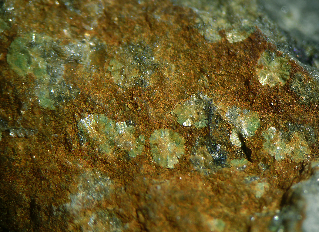
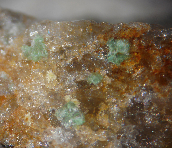
| Species: | Metazeunerite |
| Formula: | Cu(UO2)2(AsO4)2 · 8H2O |
| Confirmation |
|---|
|
| Validity: | Believed Valid |
| Associated Minerals Based on Photo Data: |
|---|
|
| Uranophane | ⓘ1 photo of Metazeunerite associated with Uranophane at this locality. |
| Data |
|---|
|
| Mineral Data: | Click here to view Metazeunerite data |
| Locality Data: | Click here to view Val Daone Mine, Limes, Daone Valley, Daone, Valdaone, Trento Province (Trentino), Trentino-Alto Adige (Trentino-South Tyrol), Italy |
| Photo Gallery | View Gallery (2 photos) |
| Data Identifiers |
|---|
|
| Mindat Occurrence Record ID: | 357673 |
| Long-form Identifier: | 1:3:357673:1 |
| GUID (UUID V4): | 7386b93a-1d43-4e1a-aebd-0b5da357da88 |
| Nearest other occurrences of Metazeunerite |
|---|
|
|
| 76.1km (47.3 miles) | ⓘVal Gardena Sandstone exposure near San Lugano pass, Carano, Ville di Fiemme, Trento Province (Trentino), Trentino-Alto Adige (Trentino-South Tyrol), Italy |
| 79.2km (49.2 miles) | ⓘTaubenleck Mine, Bletterbach Gorge, Radein (Redagno), Aldein (Aldino), Überetsch-Unterland (Oltradige-Bassa Atesina), South Tyrol, Trentino-Alto Adige (Trentino-South Tyrol), Italy |
| References |
|---|
|
|
| Reference Search (possible matching items) |
|---|
 | | Book (volume) | | francesi . . . ... Cap. XXIX - La Val d'Ala . . . . . . . . Cap. XXX - La Val d'Aosta .. . . . . Cap. XXXI...L'Ossola .. . . .. ... . . . . Cap. XXXIII - La Val di Binn . .. . . . Cap. XXXIV - Zone del Grimsel...XXXVI - 11 Canton Ticino e la Val Mesolcina .... . . . . Cap. XXXVJI - La Val Tavetsch e le valli adiacenti...adiacenti . .. . . . . . Cap. XXXVIII- La Val Malenco . . . . . . Cap. XXXIX - La Valtellina . . . . . .. ...Cap. XLI - Minerali del Vicentino Cap. XLII - La Val di Fassa e le zone adiacenti ......... . - Alpi Breonie |  | | Book (volume) | | francesi .. . .. . Cap. XXIX - La Val d'Ala . . . . . ... Cap. XXX - La Val d'Aosta . .... . Cap. XXXI - 11...- L'Ossola ... .. .. . . . . .. Cap. XXXIII - La Val di Binn .. . .. . Cap. XXXIV - Zone del Grimsel e...XXXVI - 11 Canton Ticino e la Val Mesolcina ... . .. . . Cap. XXXVII - La Val Tavetsch e le valli adiacenti...adiacenti ....... . Cap. XXXVIII - La Val Malenco ..... . Cap. XXXIX - La Valtellina .. ...... . Cap. XL -...Cap. XLI - Minerali del Vicentino Cap. XLII - La Val di Fassa e le zone adiacenti . . . . . . .. . . Cap | 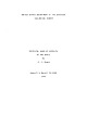 | | Report (issue) | | .............................................. South America...........................................Scotland........................................... Italy.............................................. Hungary............ 175 South Africa, Republic of.......................... 175 Namibia (South West Africa)....the Witwatersrand basin area in the Republic of South Africa (average grade 0.025 percent U308), where...g., Witwatersrand, South Africa; Blind River-Elliot Lake, Canada; Lake Frome, South Australia; Arlit area |
|


Val Daone Mine, Limes, Daone Valley, Daone, Valdaone, Trento Province, Trentino-Alto Adige, Italy