|
USA | |
|
| AZ Bur. Mines Bull. 135 (1933), AZ Gold placers and placering: 71
Wilson, E.D. (1927), AZ gokld placers, 2nd. ed. (revised), Univ. AZ Bull. 124: 52.. |
|
| Wilson, E.D. (1927), AZ Gold Placers, 2nd. ed. (revised), Univ. AZ Bull. 124: 52. |
|
| Anthony, John W., Williams, Sidney A., Bideaux, Richard A., Grant, Raymond W. (1995) Mineralogy of Arizona (3rd ed.) University of Arizona Press, Tucson, AZ. |
|
| Bonev, I. K., Petrunov, R., Cook, N. J., & Ciobanu, C. L. (2005). Kostovite and its argentian varieties: Deposits and mineral associations. Geochem. Mineral. Petrol.(Bulg. Acad. Sci.), 42, 1-22. |
|
| |
|
| AZ Bur. Mines Bull. 135 (1933), AZ Gold Placers & Placering: 72
Wilson, E.D. (1927), AZ Gold Placers, 2nd.ed. (revised), Univ. AZ Bull.124: 52
Ransome, F.L. (1904), Geology and ore deposits of Bisbee quadrangle, AZ, USGS PP 21: 121. |
|
| Keith, Stanton B. (1973), Arizona Bureau of Mines Bull. 187, Index of Mining Properties in Cochise County, AZ: 86 (Table 4)
Bryant & Metz (1966): 200-201
Bonillas, et al (1916): 350
Ransome, F.L. (1904a), The geology and ore deposits of the Bisbee quadrangle, Arizona: U.S. Geological Survey Professional Paper 21, 168 p., 3 sheets, scales 1:12,000 and 1:62,500: 119.
Arizona Bureau of Mines files. |
|
| Rob Bowell, lab tested |
|
| Robert Bowell and Rolf Luetcke |
|
| Luetcke, Rolf (n.d.) Personal communication. |
|
| Anthony, J.W., et al (1995), Mineralogy of Arizona, 3rd.ed.: 234
Bain, G.W. (1952), The age of the 'Lower Cretaceous' from Bisbee, AZ, uraninite, Econ.Geol.: 47: 305-315.
Ransome, F.L. (1904), The geology and ore deposits of the Bisbee quadrangle, AZ, USGS PP 21 |
|
| MRDS database Dep. ID file #10026894, MRDS ID #M000841. |
|
| Wilson, E.D. (1941), AZ Bur. Mines Bull. 148: 48-49. |
|
| Luetcke, Rolf (n.d.) Personal communication. |
|
| Luetcke, Rolf (n.d.) Personal communication. |
|
| Wilson, E.D. (1941), AZ Bur. Mines Bull. 148: 44. |
|
| Anthony, J.W., et al (1995), Mineralogy of Arizona, 3rd.ed.: 422. |
|
| Wilson, E.D., et al (1934), Arizona Bureau of Mines Bull. 137: 117-118. |
|
| Anthony, J.W., et al (1995), Mineralogy of Arizona, 3rd.ed.: 236
AZ Bur Mines Bull. 135 (1933), AZ Gold placers & placering: 68-69.
Wilson, E.D. (1927), AZ Gold placers, 2nd. ed. (revised), Univ. AZ Bull. 124: 51 |
|
| Luetcke, Rolf (n.d.) Personal communication. |
|
| MRDS database Dep. ID file #10104047, MRDS ID #M241011. |
|
| Keith, Stanton B. (1973), Arizona Bureau of Geology & Mineral Technology, Geol. Sur. Branch Bull. 187, Index of Mining Properties in Cochise Co., AZ: 62 (Table 4)
US Atomic Energy Commission Prelim. Reconnaisance Report A-P-74 (1953).
Tenney (1927-1929: 224 |
|
| Keith, Stanton B. (1973), Arizona Bureau of Geology & Mineral Technology, Geol. Sur. Branch Bull. 187, Index of Mining Properties in Cochise Co., AZ: 62 (Table 4)
US Atomic Energy Commission Prelim. Reconnaisance Report A-P-74 (1953).
Tenney (1927-1929: 224 |
|
| Keith, Stanton B. (1973), Arizona Bureau of Geology & Mineral Technology, Geol. Sur. Branch Bull. 187, Index of Mining Properties in Cochise Co., AZ: 62 (Table 4)
US Atomic Energy Commission Prelim. Reconnaisance Report A-P-74 (1953).
Tenney (1927-1929: 224 |
|
| Anthony, J.W., et al (1995), Mineralogy of Arizona, 3rd.ed.: 234. |
|
| Luetcke, Rolf (n.d.) Personal communication. |
|
| Anthony, J.W., et al (1995), Mineralogy of Arizona, 3rd.ed.: 236
AZ Bur. Mines Bull. 135 (1933), Arizona gold placers and placering: 69-70.
Wilson, E.D. (1927), Arizona gold placers, 2nd. Edition (revised), Univ. AZ Bull. 124: 51-52 |
|
| MRDS databse Dep. ID file #10014831, MRDS ID #D011807. |
- Dragoon District (Golden Rule District)
| Hampf, A.W. (1972) The geology of the Golden Rule mine area, Cochise County, Arizona: Tucson, University of Arizona, M.S. thesis, 156 p.
Wilson, E.D., et al (1934), AZ Bur. Mines Bull. 137: 121. |
|
| Anthony, J.W., et al (1995), Mineralogy of Arizona, 3rd.ed.: 236. |
|
| Copper Handbook 1911 |
|
| Anthony, J.W., et al (1995), Mineralogy of Arizona, 3rd.ed.: 234. |
|
| Wilson, E.D. (1927), AZ Gold Placers, 2nd.ed. (revised), Univ AZ Bull. 124: 52. |
|
| Ransome, F.L. (1904a), The geology and ore deposits of the Bisbee quadrangle, Arizona: U.S. Geological Survey Professional Paper 21, 168 p., 3 sheets, scales 1:12,000 and 1:62,500: 119. |
|
| Ronald C Render |
|
| Luetcke, Rolf (n.d.) Personal communication. |
|
| University of Arizona Bull. 41 (1916-17), Mineralogy of Useful Minerals in Arizona: 34. |
|
| Anthony, J.W., et al (1995), Mineralogy of Arizona, 3rd.ed.: 234
Howell, K.K. (1977) Geology and alteration of the Commonwealth mine, Cochise County, Arizona: Tucson, University of Arizona, M.S. thesis, 225 p.
Endlich, F.M. (1897), The Pearce mining distict, Engr.Mining Jour.: 63(23): 571. |
|
| Clive Bailey |
|
| Luetcke, Rolf (n.d.) Personal communication. |
|
| Anthony, J.W., et al (1995), Mineralogy of Arizona, 3rd.ed.: 236
AZ Bur. Mines Bull. 135 (1933), Arizona gold placers and placering: 72-73
Wilson, E.D. (1927), AZ gold placers, 2nd. ed. (revised), Univ. AZ Bull. 124: 52-53. |
|
| Anthony, J.W., et al (1995), Mineralogy of Arizona, 3rd.ed.: 234. |
|
| Anthony, J.W., et al (1995), Mineralogy of Arizona, 3rd.ed.: 234
Butler, B.S., et al (1938b), Geology and ore deposits of the Tombstone district, AZ, AZ Bur. Mines Bull. 143. |
|
| Luetcke, Rolf (n.d.) Personal communication. |
- Contention-Grand Central Mine group
| Butler, B.S., et al (1938b), Geology and ore deposits of the Tombstone district, Arizona, AZ Bur. Mines Bull. 143: 51. |
|
| Butler, B.S., et al (1938b), Geology and ore deposits of the Tombstone district, Arizona, AZ Bur. Mines Bull. 143: 51. |
|
| Butler, B.S., et al (1938b), Geology and ore deposits of the Tombstone district, Arizona, AZ Bur. Mines Bull. 143: 51.
Thorne, Brent (n.d.) Personal communcation. |
|
| Butler, B.S., et al (1938b), Geology and ore deposits of the Tombstone district, Arizona, AZ Bur. Mines Bull. 143: 51.
Wilson, E.D., et al (1934), AZ Bur. Mines Bull. 137: 124
The Resources of Arizona - A Manual of Reliable Information Concerning the Territory, compiled by Patrick Hamilton (1881), Scottsdale, AZ: 37 |
|
| Butler, B.S., et al (1938b), Geology and ore deposits of the Tombstone district, Arizona, AZ Bur. Mines Bull. 143: 51. |
|
| Butler, B.S., et al (1938b), Geology and ore deposits of the Tombstone district, Arizona, AZ Bur. Mines Bull. 143: 51. |
|
| Thorne, Brent (n.d.) Personal communcation. |
|
| Luetcke, Rolf (n.d.) Personal communication. |
|
| Butler, B.S., et al (1938b), Geology and ore deposits of the Tombstone district, Arizona, AZ Bur. Mines Bull. 143: 51. |
|
| Thorne, Brent (n.d.) Personal communcation. |
|
| Anthony, J.W., et al (1995), Mineralogy of Arizona, 3rd.ed.: 269.
Williams, Sidney A. (1980) Schieffelinite, a new lead tellurate-sulphate from Tombstone, Arizona. Mineralogical Magazine, 43 (330) 771-773 doi:10.1180/minmag.1980.043.330.11 |
|
| Robert E. Jenkins II collection and label. |
|
| Rob Bowell |
|
| Robert PECORINI collection |
|
| Anthony, J.W., et al (1995), Mineralogy of Arizona, 3rd.ed.: 307. |
|
| Anthony, J.W., et al (1995), Mineralogy of Arizona, 3rd.ed.: 320, 350.
American Mineralogist, Volume 94, pages 648–652, 2009 |
|
| MRDS database Dep. ID file #10039570, MRDS ID #M050351. |
|
| MRDS database Dep. ID file #10026911, MRDS ID #M000998. |
|
| Butler, B.S., et al (1938b), Geology and ore deposits of the Tombstone district, Arizona, AZ Bur. Mines Bull. 143: 51. |
|
| Traywick, Ben T. (1983), The Mines of Tucson: 33.
Galbraith, F.W. (1947), Minerals of AZ, AZ Bur of Mines Bull. 153: 15
Genth, F.A. (1887a), Contributions to Mineralogy, Annals of Phila. Phil. Soc.: 2:20 |
|
| Anthony, J.W., et al (1995), Mineralogy of Arizona, 3rd.ed.: 234. |
|
| Luetcke, Rolf (n.d.) Personal communication. |
|
| MRDS database Dep. ID file #10064149, MRDS ID #TC38402. |
|
| AZ Bur. Mines Bull. 135 (1933), AZ Gold Placers & Placering: 71-72. |
|
| Luetcke, Rolf (n.d.) Personal communication. |
|
| Luetcke, Rolf (n.d.) Personal communication. |
|
| Luetcke, Rolf (n.d.) Personal communication. |
|
| Luetcke, Rolf (n.d.) Personal communication. |
|
| Anthony, J.W., et al (1995), Mineralogy of Arizona, 3rd.ed.: 234. |
- Winchester Mining District
| MRDS database Dep. ID file #10098428, MRDS ID #M050676. |
- Yellowstone Mining District
| Robert Jenkins Raman Spectroscopy |
- Vermillion Cliffs Mining District
| Anthony, J.W., et al (1995), Mineralogy of Arizona, 3rd.ed.: 236, 293
Lawson, A.C. (1913), The gold in the Shinarump (Chinle) at Paria, Econ.Geol.: 8: 434-448. |
|
| (2005) Mineral Resources Data System (MRDS), US Geological Survey. |
- Richmond Basin Mining District
| MRDS database Dep. ID #10112416. |
|
| MRDS database Dep. ID #10026844, MRDS ID #M000499. |
|
| MRDS database Dep. ID #10046325. |
|
| Ross, Clyde P. (1925a) Ore deposits of the Saddle Mountain and Banner Mining Districts, Arizona. USGS Bull. 771. |
|
| Ross, Clyde P. (1925a) Ore deposits of the Saddle Mountain and Banner Mining Districts, Arizona. USGS Bull. 771.
MRDS database Dep. ID #10108973, MRDS ID #M000529. |
|
| Anthony, J.W., et al (1995), Mineralogy of Arizona, 3rd.ed.: 234. |
|
| Anthony, J.W., et al (1995), Mineralogy of Arizona, 3rd.ed.: 234. |
- Dripping Springs Mining District
| AZ Bur Mines Bull. 135 (1933), AZ gold placers and placering: 79. |
|
| Anthony, J.W., et al (1995), Minerals of Arizona, 3rd.ed.: 236.
AZ Bur. of Mines Bull. 135 (1933), AZ Gold Placers and Placering: 80 |
- Fort Apache Indian Reservation
| Moore, Richard T. (1968), AZ Bur. of Mines Bull. 177: 62
Reagan (1903), Geology of the Fort Apache region in AZ, Amer. Geologist: 32: 306. |
|
| Moore, Richard T. (1968), AZ Bur Mines Bull. 177: 17, 80. |
|
| Anthony, J.W., et al (1995), Mineralogy of Arizona, 3rd.ed.: 234
Peterson, N.P. (1962), Geology and ore deposits of the Globe-Miami district, AZ, USGS PP 342.
Ransome, F.L. (1903a), Geology of the Globe copper district, AZ, USGS PP 12 |
- Globe Hills Mining District
| Peterson, N.P. (1962), Geology and ore deposits of the Globe-Miami District, Arizona, USGS PP 342: 69, 118
Ransome (1903): 154. |
|
| Peterson, N.P. (1962), Geology and ore deposits of the Globe-Miami District, Arizona, USGS PP 342: 133. |
|
| Peterson, N.P. (1962), Geology and ore deposits of the Globe-Miami District, Arizona, USGS PP 342: 133. |
|
| Peterson, N.P. (1962), Geology and ore deposits of the Globe-Miami District, Arizona, USGS PP 342: 133. |
|
| Peterson, N.P. (1962), Geology and ore deposits of the Globe-Miami District, Arizona, USGS PP 342: 133. |
|
| AZ Bur. Mines Bull. 135 (1933), AZ Gold Placers and Placering: 80. |
|
| AZ Bur. Mines Bull. 135 (1933), AZ Gold Placers and Placering: 80.
Wilson, E.D. (1927), AZ Gold placers, 2nd. ed. (revised), Univ. AZ Bull. 124: 57-58 |
|
| Peterson, N.P. (1962), Geology and ore deposits of the Globe-Miami District, Arizona, USGS PP 342: 133. |
|
| Anthony, J.W., et al (1995), Mineralogy of Arizona, 3rd.ed.: 234. |
|
| Peterson, N.P. (1962), Geology and ore deposits of the Globe-Miami District, Arizona, USGS PP 342: 133. |
- Miami-Inspiration Mining District
| MRDS database Dep. ID #10161309, MAS ID #0040070341. |
|
| Peterson, N.P. (1962), Geology and ore deposits of the Globe-Miami District, Arizona, USGS PP 342: 133. |
|
| MRDS database Dep. ID #10112717, MAS ID #0040070405. |
|
| Wilson, E.D. (1927), AZ Gold Placers, 2nd.ed. (revised), Univ. AZ Bull.124: 57. |
- Miami-Inspiration deposit
| MRDS database Dep. ID #10027438, MRDS ID #M003084. |
|
| AZ Bur. Mines Bull. 135 (1933), AZ Gold placers & placering: 81.
Wilson, E.D. (1927), AZ Gold placering, 2nd. ed. (revised), Univ. AZ Bull. 124: 57 |
|
| MRDS database Dep. ID #10112546, MAS ID #0040070470. |
|
| Anthony, J.W., et al (1995), Mineralogy of Arizona, 3rd.ed.: 236. |
|
| Wilson, E.D., et al (1934), Arizona Bureau of Mines Bull. 137: 182-185. |
|
| Wilson, E.D., et al (1934), AZ Bur. Mines Bull. 137: 184. |
|
| Anthony, J.W., et al (1995), Mineralogy of Arizona, 3rd.ed.: 209. |
|
| Wilson, E.D., et al (1934), AZ Bur. Mines Bull. 137: 183-184. |
|
| AZ Bur. Mines Bull. 135 (1933), AZ Gold placers and placering: 81.
Wilson, E.D. (1927), AZ gold placers, 2nd.ed. (revised), Univ. AZ Bull. 124: 58 |
|
| Anthony,. J.W., et al (1995), Mineralogy of Arizona, 3rd.ed.: 236. |
|
| Lausen, C. & E.D. Wilson (1925), Gold and copper deposits near Payson, Arizona, Arizona Bureau of Mines Bull. 120: 40
MRDS database Dep. ID #10095034, MRDS ID #M002904. |
|
| MRDS database Dep. ID #10046304, MRDS ID #M241206. |
- Pinal Mountains Mining District
- Ice House CCC Campgrounds area
| MRDS database Dep. ID #10258358, MAS ID #0040070621. |
|
| MRDS database Dep. ID #10233924, MAS ID #0040070599. |
|
| MRDS database Dep. ID #10102398, MRDS ID #M000370. |
|
| MRDS database Dep. ID #10112429, MAS ID #0040070234. |
- Tonto Basin Mining District
| MRDS database Dep. ID #10137075, MAS ID #0040070550. |
|
| Anthony, J.W., et al (1995), Mineralogy of Arizona, 3rd.ed.: 235. |
|
| Anthony, J.W., et al (1995), Mineralogy of Arizona, 3rd.ed.: 235. |
|
| Wilson, E.D., et al (1934), AZ Bur. of Mines Bull. 137: 192. |
|
| Wilson, E.D., et al (1934), AZ Bur. of Mines Bull. 137: 193. |
|
| AZ Bur. Mines Bull. 135 (1933), AZ Gold Placers and Placering: 81-82. |
- Lone Star Mining District (Safford Mining District; Dos Pobres Mining District)
| MRDS database Dep. ID #10027108, MRDS ID #M002123. |
|
| (2005) Mineral Resources Data System (MRDS), US Geological Survey. |
|
| Les and Paula Presmyk collection |
|
| Wilson, E.D., et al (1934), AZ Bur. of mines Bull. 137:192. |
|
| MRDS database Dep. ID #10026888, MRDS ID #M000791. |
|
| Anthony, J.W., et al (1995), Mineralogy of Arizona, 3rd.ed.: 234
Blake, W.P. (1902), The geology of the Galiuro Mountains, AZ, and of the gold-bearing ledge known as Gold Mountain, Engr. Mining Jour.: 73: 546. |
|
| Wilson, E.D., et al (1934), AZ Bur. Mines Bull. 137: 193. |
|
| Wilson, E.D., et al (1934), AZ Bur. Mines Bull. 137: 194. |
|
| Anthony, J.W., et al (1995), Mineralogy of Arizona, 3rd.ed.: 235. |
|
| (2005) Mineral Resources Data System (MRDS), US Geological Survey. |
|
| Anthony, J.W., et al (1995), Mineralogy of Arizona, 3rd.ed.: 235. |
|
| MRDS database Dep. ID #10048294, MRDS ID #M800426. |
|
| MRDS database Dep. ID #10108994, MRDS ID #M001287. |
- Gila Hot Springs Mining District
| MRDS database Dep. ID #10107997, MRDS ID #D011415. |
|
| AZ Gold Placers & Placering, AZ Bur. of Mines Bull. 135 (1933): 73-74
MRDS database Dep. ID #10026955, MRDS ID #M001275.. |
|
| AZ Gold Placers & Placering, AZ Bur. of Mines Bull. 135 (1933): 73-74. |
|
| AZ Bur. Mines Bull. 135 (1933), AZ gold placers & placering: 74. |
|
| Wilson, E.D., et al (1934), AZ Bur. of Mines Bull. 137: 187 |
|
| AZ Bur. Mines Bull. 135 (1933), AZ Gold Placers & Placering: 73.
Wilson, E.D. (1927), AZ Gold Placers, 2nd.ed. (revised), Univ. AZ Bull.124: 53 |
|
| Wilson, E.D., et al (1934), AZ Bur. Mines Bull. 137: 187. |
|
| Wilson, E.D. (1927), AZ gold placers, 2nd. ed. (revised), Univ. AZ Bull. 124: 53
Lindgren, W. (1905), Copper deposits of Clifton-Morenci district, AZ, USGS PP 43: 205. |
|
| MRDS database Dep. ID #10282444, MAS ID #0040110018. |
|
| The Resources of Arizona - A Manual of Reliable Information Concerning the Territory, compiled by Patrick Hamilton (1881), Scottsdale, AZ: 78. |
|
| Anthony, J.W., et al (1995), Mineralogy of Arizona, 3rd.ed.: 235. |
|
| Anthony, J.W., et al (1995), Mineralogy of Arizona, 3rd.ed.: 236
Jones, E.L., Jr. (1915), Gold deposits near Quartzsite, AZ, USGS Bull. 620: 45-57. |
|
| Wilson, E.D., et al (1934)(revised 1967), Arizona Bureau of Mines Bull. 137: 126-127. |
|
| Keith, Stanton B. (1978) State of Arizona Bureau of Geology and Mineral Technology, Geol. Sur. Br. Bull. 192, Index of Mining Properties in Yuma Co., Arizona: 123 (Table 4). |
|
| (n.d.) ADMMR Mines Database, Arizona Geological Survey.
Keith, Stanton B. (1978) State of Arizona Bureau of Geology and Mineral Technology, Geol. Sur. Br. Bull. 192, Index of Mining Properties in Yuma Co., Arizona: 123 (Table 4)
Wilson, E.D. (1934)(revised 1969): 127 |
|
| Keith, Stanton B. (1978) State of Arizona Bureau of Geology and Mineral Technology, Geol. Sur. Br. Bull. 192, Index of Mining Properties in Yuma Co., Arizona: 142 (Table 4). |
|
| David Shannon Label (1727 W Drake Circle) |
|
| Keith, Stanton B. (1978) State of Arizona Bureau of Geology and Mineral Technology, Geol. Sur. Br. Bull. 192, Index of Mining Properties in Yuma Co., Arizona: 142 (Table 4). |
|
| Arthur L. Flagg Collection No. 2161 |
- Mammoth-Chicago-Copper Glance Mine group
| MRDS database Dep. ID file #10027050, MRDS ID #M001814. |
- Santa Maria Mining District (Planet Mining District; Swansea Mining District; Bill Williams Mining District)
| (n.d.) ADMMR Mines Database, Arizona Geological Survey.
Keith, Stanton B. (1978) State of Arizona Bureau of Geology and Mineral Technology, Geol. Sur. Br. Bull. 192, Index of Mining Properties in Yuma Co., Arizona: 172 (Table 4)
Wilson, et al (1934) (revised 1967): 128
Bancroft (1911): 51 |
|
| (n.d.) ADMMR Mines Database, Arizona Geological Survey.
Keith, Stanton B. (1978) State of Arizona Bureau of Geology and Mineral Technology, Geol. Sur. Br. Bull. 192, Index of Mining Properties in Yuma Co., Arizona: 173 (Table 4) |
|
| (n.d.) ADMMR Mines Database, Arizona Geological Survey.
Keith, Stanton B. (1978) State of Arizona Bureau of Geology and Mineral Technology, Geol. Sur. Br. Bull. 192, Index of Mining Properties in Yuma Co., Arizona: 173 (Table 4)
Bancroft (1911): 65-66 |
|
| Wilson, E.D., et al (1934), AZ Bur. Mines Bull. 137: 128. |
|
| Keith, Stanton B. (1978) State of Arizona Bureau of Geology and Mineral Technology, Geol. Sur. Br. Bull. 192, Index of Mining Properties in Yuma Co., Arizona: 116 (Table 4)
Wilson, E.D. (1933), AZ Bur. of Mines Bull. 134: 118-119.
Jones, E.L., Jr. (1915), A Reconnaissance in the Kofa Mountains, Arizona, USGS Bull. 620: 163 |
|
| Anthony, J.W., et al (1995), Mineralogy of Arizona, 3rd.ed.: 235. |
- La Cholla Mining District
| Keith, Stanton B. (1978) State of Arizona Bureau of Geology and Mineral Technology, Geol. Sur. Br. Bull. 192, Index of Mining Properties in Yuma Co., Arizona: 156 (Table 4). |
|
| Keith, Stanton B. (1978) State of Arizona Bureau of Geology and Mineral Technology, Geol. Sur. Br. Bull. 192, Index of Mining Properties in Yuma Co., Arizona: 156 (Table 4). |
|
| Melchiorre, Erik B., Mathur, Ryan, Kamenov, George, Paredes, Jorge (2023) Geochemical Overprinting and Secondary Placer Crystal Formation in the La Cholla District, Quartzsite, Arizona, USA: Evidence from Copper Isotopes, Morphology, and Trace Elements. Minerals, 13 (11) doi:10.3390/min13111444
Keith, Stanton B. (1978) State of Arizona Bureau of Geology and Mineral Technology, Geol. Sur. Br. Bull. 192, Index of Mining Properties in Yuma Co., Arizona: 157 (Table 4)
AZ Bur. Mines Bull. 135 (1933), AZ Gold placers & placering: 29-30.
Wilson, E.D. (1927), Arizona gold placers, 2nd. ed. (revised), Univ. AZ Bull. 124: 20 |
- La Paz Mining District (Weaver Mining District)
| Mins. Today, US Bur. Mines(Jan90):26. |
|
| Jones, Jr., E.L. (1915), Gold Deposits near Quartzsite, Arizona, in Contributions to Economic Geology by F.L. Ransome & H.S. Gale, USGS Bull. 620: 56-57. |
|
| (n.d.) ADMMR Mines Database, Arizona Geological Survey.
Keith, Stanton B. (1978) State of Arizona Bureau of Geology and Mineral Technology, Geol. Sur. Br. Bull. 192, Index of Mining Properties in Yuma Co., Arizona: 159 (Table 4) |
|
| (n.d.) ADMMR Mines Database, Arizona Geological Survey.
Ref.: Keith, Stanton B. (1978) State of Arizona Bureau of Geology and Mineral Technology, Geol. Sur. Br. Bull. 192, Index of Mining Properties in Yuma Co., Arizona: 159 (Table 4) |
|
| Jones, Jr., E.L. (1915). Gold deposits near Quartzsite, AZ, USGS Bull. 620: 55. |
|
| Wilson, E.D., et al (1934), AZ Bur. Mines Bull. 137: 136
Jones, Jr., E.L. (1915). Gold deposits near Quartzsite, AZ, USGS Bull. 620: 55. |
|
| (n.d.) ADMMR Mines Database, Arizona Geological Survey.
Ref.: Keith, Stanton B. (1978) State of Arizona Bureau of Geology and Mineral Technology, Geol. Sur. Br. Bull. 192, Index of Mining Properties in Yuma Co., Arizona: 159 (Table 4) |
|
| (n.d.) ADMMR Mines Database, Arizona Geological Survey.
Keith, Stanton B. (1978) State of Arizona Bureau of Geology and Mineral Technology, Geol. Sur. Br. Bull. 192, Index of Mining Properties in Yuma Co., Arizona: 159 (Table 4)
AZ Bur. Mines Bull. 135 (1933), AZ gold placers & placering: 124-128
Wilson, E.D. (1927), Arizona gold placers, 2nd. ed. (revised), Univ. AZ Bull. 124: 12-18 |
|
| AZ Bur. of Mines Bull. 135 (1933), AZ Gold Placers & Placering: 27
Wilson, E.D. (1927), AZ Go,ld Placers, 2nd. ed., revised, Univ. of AZ Bull. No. 124: 12-18
Jones, Jr., E.L. (1915), Gold Deposits near Quartzsite, Arizona, in Contributions to Economic Geology by F.L. Ransome & H.S. Gale, USGS Bull. 620: 51. |
|
| AZ Bur. Mines Bull. 135 (1933), AZ Gold placers and placering: 27
Wilson, E.D. (1927), AZ Gold placers, 2nd. ed. (revised), Univ. AZ Bull. 124: 12-18
Jones, Jr., E.L. (1915), Gold Deposits near Quartzsite, Arizona, in Contributions to Economic Geology by F.L. Ransome & H.S. Gale, USGS Bull. 620: 51. |
|
| AZ Bur. Mines Bull. 135 (1933), AZ Gold Placers & Placering: 27.
Wilson, E.D. (1927), AZ Gold Placers, 2nd.ed. (revised), Univ AZ Bull. 124: 12-18 |
|
| AZ Bur. of Mines Bull. 135 (1933), AZ Gold Placers & Placering: 27
Wilson, E.D. (1927), AZ Go,ld Placers, 2nd. ed., revised, Univ. of AZ Bull. No. 124: 12-18
Jones, Jr., E.L. (1915), Gold Deposits near Quartzsite, Arizona, in Contributions to Economic Geology by F.L. Ransome & H.S. Gale, USGS Bull. 620: 50-51. |
|
| AZ Bur. of Mines Bull. 135 (1933), AZ Gold Placers & Placering: 27.
Wilson, E.D. (1927), AZ Gold Placers, 2nd. ed., revised, Univ. of AZ Bull. No. 124: 12-18 |
- Middle Camp-Oro Fino Mining District
| Keith, Stanton B. (1978) State of Arizona Bureau of Geology and Mineral Technology, Geol. Sur. Br. Bull. 192, Index of Mining Properties in Yuma Co., Arizona: 162 (Table 4)
AZ Bur. Mines Bull. 135 (1933), AZ Gold placers & placering: 29-31.
Wilson, E.D. (1927), AZ Gold placers, 2nd. ed. (revised), Univ. AZ Bull. 124: 20
Arizona Bureau of Mines file data |
|
| Keith, Stanton B. (1978) State of Arizona Bureau of Geology and Mineral Technology, Geol. Sur. Br. Bull. 192, Index of Mining Properties in Yuma Co., Arizona: 162 (Table 4)
AZ Bur. Mines Bull. 135 (1933), AZ gold placers and placering: 29, 30
Wilson, E.D. (1927), AZ Gold placers, 2nd. ed. (revised), Univ. AZ Bull. 124: 20
Jones, Jr., E.L. (1915), Gold Deposits near Quartzsite, Arizona, in Contributions to Economic Geology by F.L. Ransome & H.S. Gale, USGS Bull. 620: 52.
Arizona Bureau of Mines file data |
|
| MRDS database Dep. ID file #10027894, MRDS ID #M004374. |
|
| MRDS database Dep. ID file #10037077, MRDS ID #M030338. |
- Gila Bend Mountains Mining District
| AZ Bur. of Mines Bull. 134: 146. |
|
| AZ Bur. of Mines Bull. 134: 147. |
|
| Keith, Stanton B. (1978) State of Arizona Bureau of Geology and Mineral Technology, Geol. Sur. Br. Bull. 192, Index of Mining Properties in Yuma Co., Arizona: 150-151 (Table 4). |
|
| Keith, Stanton B. (1978) State of Arizona Bureau of Geology and Mineral Technology, Geol. Sur. Br. Bull. 192, Index of Mining Properties in Yuma Co., Arizona: 150-151 (Table 4)
Wilson, E.D. (1933), AZ Bur. Mines Bull. 134: 146.. |
|
| Keith, Stanton B. (1978) State of Arizona Bureau of Geology and Mineral Technology, Geol. Sur. Br. Bull. 192, Index of Mining Properties in Yuma Co., Arizona: 150-151 (Table 4). |
|
| Keith, Stanton B. (1978) State of Arizona Bureau of Geology and Mineral Technology, Geol. Sur. Br. Bull. 192, Index of Mining Properties in Yuma Co., Arizona: 150-151 (Table 4). |
|
| Keith, Stanton B. (1978) State of Arizona Bureau of Geology and Mineral Technology, Geol. Sur. Br. Bull. 192, Index of Mining Properties in Yuma Co., Arizona: 150-151 (Table 4)
Wilson, E.D. (1933), Geology and mineral deposits of southern Yuma Co., AZ, AZ Bur. of Mines Bull. 134: 145-147.. |
- Eagletail Mts (Cemetary Ridge)
- Eagle Tail Mining District
| MRDS database Dep. ID file #10027605, MRDS ID #M003496. |
- Ellsworth Mining District
| The Resources of Arizona - A Manual of Reliable Information Concerning the Territory, compiled by Patrick Hamilton (1881), Scottsdale, AZ: 74. |
|
| MRDS database Dep. ID file #10027677, MRDS ID #M003794. |
|
| Verbal Jerry Baird |
|
| MRDS database Dep. ID file #10027680, MRDS ID #M003802. |
|
| (n.d.) ADMMR Mines Database, Arizona Geological Survey.
Keith, Stanton B. (1978) State of Arizona Bureau of Geology and Mineral Technology, Geol. Sur. Br. Bull. 192, Index of Mining Properties in Yuma Co., Arizona: 148 (Table 4)
Johnson (1972): 74-75
Bancroft (1911): 98, 102 |
|
| The Resources of Arizona - A Manual of Reliable Information Concerning the Territory, compiled by Patrick Hamilton (1881), Scottsdale, AZ: 74. |
|
| The Resources of Arizona - A Manual of Reliable Information Concerning the Territory, compiled by Patrick Hamilton (1881), Scottsdale, AZ: 74. |
|
| MRDS database Dep. ID file #10113441, MRDS ID #M003843, MAS ID #0040120009. |
|
| MRDS database Dep. ID file #10027694, MRDS ID #M003845. |
- Harquahala Mining District
| Wilson, E.D., et al (1934), AZ Bur. of Mines Bull. 137: 133. |
|
| AZ Bur. Mines Bull. 135 (1933), AZ Gold Placers & Placering: 32. |
|
| Wilson, E.D., et al (1934), AZ Bur. Mines Bull. 137: 131-132. |
|
| Keith, Stanton B. (1978) State of Arizona Bureau of Geology and Mineral Technology, Geol. Sur. Br. Bull. 192, Index of Mining Properties in Yuma Co., Arizona: 153 (Table 4). |
|
| Wilson, E.D., et al (1934)(revised 1967), AZ Bur. Mines Bull. 137: 132. |
|
| AZ Bur. Mines Bull. 135 (1933), AZ gold placers and placering: 28-29.
Wilson, E.D. (1927), AZ gold placers, 2nd. ed. (revised), Univ. AZ Bull. 124: 18-19 |
|
| AZ Bur. Mines Bull. 135 (1933), AZ gold placers and placering: 29, 31-32. |
|
| Anthony, J.W., et al (1995), Mineralogy of Arizona, 3rd.ed.: 235. |
|
| (n.d.) ADMMR Mines Database, Arizona Geological Survey.
Keith, Stanton B. (1978) State of Arizona Bureau of Geology and Mineral Technology, Geol. Sur. Br. Bull. 192, Index of Mining Properties in Yuma Co., Arizona: 168 (Table 4)
Jemmett (1968)
Wilson, E.D., et al (1934)(revised 1967), AZ Bur. Mines Bull. 137: 134-135 |
|
| (n.d.) ADMMR Mines Database, Arizona Geological Survey.
Keith, Stanton B. (1978) State of Arizona Bureau of Geology and Mineral Technology, Geol. Sur. Br. Bull. 192, Index of Mining Properties in Yuma Co., Arizona: 170 (Table 4)
Bancroft (1911): 93-95 |
|
| MRDS database Dep. ID file #10027049, MRDS ID #M001809. |
|
| Bancroft, H. (1911), Reconnaissance of the ore deposits in northern Yuma Co, AZ, USGS Bull. 451. MRDS database Dep. ID file #10027048, MRDS ID #M001807. |
|
| (n.d.) ADMMR Mines Database, Arizona Geological Survey.
Keith, Stanton B. (1978) State of Arizona Bureau of Geology and Mineral Technology, Geol. Sur. Br. Bull. 192, Index of Mining Properties in Yuma Co., Arizona: 170 (Table 4)
Dale (1959): 24-25 |
|
| (n.d.) ADMMR Mines Database, Arizona Geological Survey.
Keith, Stanton B. (1978) State of Arizona Bureau of Geology and Mineral Technology, Geol. Sur. Br. Bull. 192, Index of Mining Properties in Yuma Co., Arizona: 170 (Table 4)
Wilson, E.D., et al (1934)(revised 1967), AZ Bur. Mines Bull. 137: 135 |
|
| (n.d.) ADMMR Mines Database, Arizona Geological Survey.
Keith, Stanton B. (1978) State of Arizona Bureau of Geology and Mineral Technology, Geol. Sur. Br. Bull. 192, Index of Mining Properties in Yuma Co., Arizona: 168 (Table 4)
Bancroft (1911): 89-90 |
|
| Arizona Bureau of Mines file data. MRDS database Dep. ID file #10186484, MAS ID #0040120419. |
- Bonanza and Golden Eagle Mine group
| Keith, Stanton B. (1978) State of Arizona Bureau of Geology and Mineral Technology, Geol. Sur. Br. Bull. 192, Index of Mining Properties in Yuma Co., Arizona: 151 (Table 4). |
- Imperial National Wildlife Refuge
| AZ Bur. Mines Bull. 135 (1933), Arizona gold placers and placering: 23. |
|
| (n.d.) ADMMR Mines Database, Arizona Geological Survey.
Keith, Stanton B. (1978) State of Arizona Bureau of Geology and Mineral Technology, Geol. Sur. Br. Bull. 192, Index of Mining Properties in Yuma Co., Arizona: 176 (Table 4)
Johnson (1972): 75-76
Wilson, E.D. (1961): 25
Burchard (1882) |
|
| Anthony, J.W., et al (1995), Mineralogy of Arizona, 3rd.ed.: 235. |
- Trigo Mountains Mining District (Cibola Mining District)
| AZ Bur. of Mines Bull. 134: 73. |
|
| MRDS database Dep. ID file #10102453, MRDS ID #M002427. |
|
| Wilson, E.D. (1933), AZ Bur. Mines Bull. 134: 73. |
|
| (n.d.) ADMMR Mines Database, Arizona Geological Survey.
Keith, Stanton B. (1978) State of Arizona Bureau of Geology and Mineral Technology, Geol. Sur. Br. Bull. 192, Index of Mining Properties in Yuma Co., Arizona: 181 (Table 4)
Johnson (1972): 75-76
Wilson (1961): 25 |
- Agua Fria Mining District
| Anthony, J.W., et al (1995), Mineralogy of Arizona, 3rd.ed.: 236
Carter, T.L. (1911), Gold placers in Arizona, Engr. Mining Jour. 90: 561. |
|
| MRDS file #10234937. |
|
| Anthony, J.W., et al (1995), Mineralogy of Arizona, 3rd.ed.: 236
Carter, T.L. (1911), Gold Placers in AZ, Engr. Mining Jour.: 90: 561. |
|
| Anthony, J.W., et al (1995), Mineralogy of Arizona, 3rd.ed.: 235. |
- Cave Creek Mining District
| MRDS file #10046362. |
|
| Wilson, E.D. (1941), AZ Bur. Mines Bull. 148: 26-27. |
|
| MRDS file #10138013. |
|
| (1972) Placer gold deposits of Arizona. Bulletin Vol. 1355. US Geological Survey doi:10.3133/b1355
MRDS file #10258857. |
|
| Wilson, E.D. (1927), AZ Gold Placers, 2nd.ed. (revised), Univ AZ Bull. 124: 47. |
|
| Wilson, E.D. (1927), AZ Gold Placers, 2nd.ed. (revised), Univ AZ Bull. 124: 47. |
- Gila River Indian Reservation
- Salt River Mining District
| Wilson, E.D. (1969), AZ Bur. Mines Bull. 179: 25. |
|
| MRDS file #10090734. |
- Goldfields Mining District
| Megaw, Peter (2023) Personal Communication. |
|
| MRDS file #10186456. |
- Fourth of July Peak (Fourth of July Butte)
| MRDS file #10210398. |
|
| AZ Dept. Min. Resources (ADMR) Little Sam file
MRDS file #10283280. |
|
| (1972) Placer gold deposits of Arizona. Bulletin Vol. 1355. US Geological Survey doi:10.3133/b1355
Wilson E.D. (1961), Gold placers and placering in Arizona AZ Bur. of Mines Bull. 168: 59-60
MRDS file #10210487. |
|
| MRDS file #10234433. |
|
| MRDS file #10234736. |
|
| Betts, John (n.d.) John Betts website listing. |
- New River Mining District
| Rocks & Min.: 24:254. |
|
| Collected by E. Stuart, Jackson, MS. |
|
| Anthony, J.W., et al (1995), Mineralogy of Arizona, 3rd.ed.: 197. |
|
| Wilson, E.D., et al (1934), AZ Bur. of Mines Bull. 137:165. |
|
| Anthony, J.W., et al (1995), Mineralogy of Arizona, 3rd.ed.: 236
Carter, T.L. (1911), Gold Placers in AZ, Engr. Mining Jour.: 90: 561. |
|
| Wilson, E.D., et al (1934), AZ Bur. Mines Bull. 137: 165. |
|
| Wilson, E.D., et al (1934), AZ Bur. Mines Bull. 137: 164-165. |
|
| Wilson, E.D., et al (1934), AZ Bur. Mines Bull. 137: 164. |
|
| The Resources of Arizona - A Manual of Reliable Information Concerning the Territory, compiled by Patrick Hamilton (1881), Scottsdale, AZ: 76. |
|
| Wilson, E.D., et al (1934), AZ Bur. Mines Bull. 137: 164. |
|
| Wilson, E.D., et al (1934), AZ Bur Mines Bull. 137: 165.
The Resources of Arizona - A Manual of Reliable Information Concerning the Territory, compiled by Patrick Hamilton (1881), Scottsdale, AZ: 76 |
|
| Wilson, E.D., et al (1934), AZ Bur. Mines Bull. 137: 164. |
|
| Anthony, J.W., et al (1995), Mineralogy of Arizona, 3rd.ed.: 235. |
|
| Tenney, J.B. (1928), AZ Bur. of Mines Bull. 125, The Mineral Industries of AZ: 98-99. |
|
| Wilson, E.D., et al (1934), AZ Bur. of mines Bull. 137: 165. |
|
| Anthony, J.W., et al (1995), Mineralogy of Arizona, 3rd.ed.: 236. |
|
| Anthony, J.W., et al (1995), Mineralogy of Arizona, 3rd.ed.: 236
Carter, T.L. (1911), Gold Placers in AZ, Engr. Mining Jour.: 90: 561. |
- Pikes Peak Mining District
| MRDS file #10027869. |
|
| Luetcke, Rolf (n.d.) Personal communication. |
- Red Picacho Mining District
| MRDS file #10027317. |
|
| MRDS file #10046344. |
|
| AZ Dept. Min. Resources (ADMR) information
MRDS file #10113364. |
|
| Sorrell, Steve (n.d.) Personal communication. |
|
| collected by and in the collection of Eckhard D. Stuart |
|
| Anthony, J.W., et al (1995), Mineralogy of Arizona, 3rd.ed.: 235
Metzger, O.H. (1938), Gold mining and milling in the Wickenburg area, Maricopa and Yavapai Cos., AZ, US Bur. of Mines Info. Circ. 6991. |
|
| Metzger, O.H. (1938), Gold mining and milling in the Wickenburg area, Maricopa and Yavapai Counties, Arizona: US Bur. Mines Info. Circ. 6991
MRDS file #10027274. |
|
| MRDS file #10102529. |
|
| AZ Bur. Mines Bull. 135 (1933), AZ Gold Placers & Placering.
Wilson, E.D. (1927), AZ Gold placers, 2nd. ed. (revised), Univ. AZ Bull. 124: 48-49 |
|
| MRDS file #10056391. |
|
| Wilson, E.D., et al (1934), AZ Bur. of Mines Bull. 137: 163. |
|
| Metzger, O.H. (1938), Gold mining and milling in the Wickenburg area, Maricopa and Yavapai Counties, Arizona: US Bureau of Mines Information Circular 6991: 64.
MRDS file #10027087. |
|
| Wilson, E.D., et al (1934), AZ Bur. of Mines Bull. 137: 157. |
|
| Anthony, J.W., et al (1995), Mineralogy of Arizona, 3rd.ed.: 236
AZ Bur. of Mines Bull. 135 (1933), AZ Gold Placers & Placering: 65-66.
Wilson, E.D. (1927), AZ Gold Placers, 2nd. ed revised, Univ. of AZ Bull. 124: 45-47
Carter, T.L. (1911), Gold placers in AZ, Engr. Mining Jour.: 90:561 |
|
| AZ Bur. of Mines Bull. 135 (1933), AZ Gold Placers & Placering: 65-66.
Wilson, E.D. (1927), AZ Gold Placers, 2nd. ed revised, Univ. of AZ Bull. 124: 45-47 |
|
| AZ Bur. of Mines Bull. 135 (1933), AZ Gold Placers & Placering: 65-66.
Wilson, E.D. (1927), AZ Gold Placers, 2nd. ed revised, Univ. of AZ Bull. 124: 45-47 |
|
| Anthony, J.W., et al (1995), Mineralogy of Arizona, 3rd.ed.: 261
Wilson, E.D., et al (1934), AZ Bur. of Mines Bull. 137: 157-162.
Silliman, B. (1879), Jarosite (with gold), Amer.Jour.Sci.: 17:73 |
- White Picacho Mining District
- Little San Domingo Wash area
| MRDS file #10048180. |
|
| MRDS file #10027315. |
- San Domingo Mining District
| Wilson, E.D. (1927), AZ gokld placers, 2nd. ed. (revised), Univ. AZ Bull. 124: 47. |
|
| Anthony, J.W., et al (1995), Mineralogy of Arizona, 3rd.ed.: 236
Wilson, E.D. (1927), AZ gold placers, 2nd. ed. (revised), Univ. AZ Bull. 124: 47-48
Carter, T.L. (1911), Gold placers in Arizona, Engr. Mining Jour.: 90: 561. |
|
| docs.azgs.az.gov (2017) http://docs.azgs.az.gov/OnlineAccessMineFiles/C-F/DragonMaricopa331.pdf |
|
| On a specimen collected by Joe Ruiz |
|
| MRDS file #10027608. |
|
| Collected by Joe Ruiz. In the collection of Brent Thorne. |
- Cleopatra Mining District
- Kimble Mining Sub-District
| MRDS file #10027683. |
- Bill Williams Fork Mining District
- Bill Williams Fork (Williams Fork)
| Anthony, John W., Williams, Sidney A., Bideaux, Richard A., Grant, Raymond W. (1995) Mineralogy of Arizona (3rd ed.) University of Arizona Press, Tucson, AZ.
Blake, W.P. (1865). |
- El Dorado Pass Mining District
| Wilson, E.D., et al (1934), AZ Bur. of Mines Bull. 137: 79-80. |
|
| Wilson, E.D., et al (1934), AZ Bur. of Mines Bull. 137: 78. |
|
| Ransome, F.L. (1923), Geol. of the Oatman gold district, AZ, a preliminary report, USGS Bull. 743.
The Resources of Arizona - A Manual of Reliable Information Concerning the Territory, P. Hamilton (1881): 70
Silliman, B. (1866), On some mining districts of AZ near Rio Colorado, ...., Amer.Jour.Sci.: 41:289-308 |
|
| MRDS file #10161751. |
|
| MRDS file #10027076. |
- Gold Dust vein (Victor-Virgin vein)
| MRDS file #10027916. |
- Gold Road Mining District
| Wilson, E.D., et al (1934), AZ Bur. of Mines Bull. 137: 94
Ransome, F.L. (1923), Geology of the Oatman Gold District, Arizona, USGS Bull. 743: 33.
The Resources of Arizona - A Manual of Reliable Information Concerning the Territory, compiled by Patrick Hamilton (1881), Scottsdale, AZ: 70
The History of Arizona, Chap. X: 74 |
|
| Wilson, E.D., et al (1934), AZ Bur. of Mines Bull. 137: 98-99. |
|
| MRDS fle #10027943. |
|
| Wilson, E.D., et al (1934), AZ Bur. of Mines Bull. 137: 98. |
|
| Schrader, F.C. (1909), Mineral deposits of the Cerbat Range, Black Mountains, and the Grand Wash Cliffs, Mohave County, Arizona: USGS Bull. 397: 166
MRDS file #10027908. |
|
| Wilson, E.D., et al (1934), AZ Bur. of Mines Bull. 137: 79. |
|
| Wilson, E.D., et al (1934), AZ Bur. of Mines Bull. 137: 98. |
|
| Conrad, J.E., et al (1990), Mineral Resources of the Black Mountains North and Burns Spring Wilderness Study Areas, Mohave County, Arizona, USGS Bull. 1737-C: C7. |
|
| Wilson, E.D., et al (1934), AZ Bur. of Mines Bull. 137: 78-79. |
|
| Luetcke, Rolf (n.d.) Personal communication. |
|
| MRDS #10027917. |
|
| MRDS file #10027922. |
|
| MRDS file #10027924. |
|
| Ransome, F.L. (1923), Geology of the Oatman Gold District, Arizona, USGS Bull. 743: 33. |
|
| Wilson, E.D., et al (1934), AZ Bur. of Mines Bull. 137: 99. |
|
| Ransome, F.L. (1923), Geology of the Oatman Gold District, Arizona, USGS Bull. 743: 33. |
|
| A.I.M.E. Ore Deposits of the Western States (1933): 166. |
|
| MRDS file #10137573. |
|
| MRDS file #10102578. |
|
| Schrader, F.C. (1909), Mineral deposits of the Cerbat Range, Black Mountains, and the Grand Wash Cliffs, Mohave County, Arizona: USGS Bulletin 397: 183-186. |
|
| Schrader, F.C. (1909), Mineral deposits of the Cerbat Range, Black Mountains, and the Grand Wash Cliffs, Mohave County, Arizona: USGS Bull. 397
MRDS file #10026989. |
|
| MRDS file #10027915. |
|
| Wilson, E.D., et al (1934), AZ Bur. of Mines Bull. 137: 94-95. |
|
| AZ Bur. of Mines Bull. 135 (1933), AZ Gold Placers & Placering: 87. |
|
| MRDS file #10027921. |
|
| MRDS file #10027919. |
|
| Wilson, E.D., et al (1934), AZ Bur. of Mines Bull. 137: 90. |
|
| A.I.M.E. Ore Deposits of the Western United States (1933): 166. |
|
| MRDS file #10027937. |
|
| MRDS file #10027914. |
|
| MRDS file #10027946. |
- San Francisco Mining District
| MRDS file #10027925. |
|
| MRDS file #10259494. |
|
| Wilson, E.D., et al (1934), AZ Bur. of Mines Bull. 137: 104-105. |
|
| Schrader, F.C. (1909), Mineral deposits of the Cerbat Range, Black Mountains, and the Grand Wash Cliffs, Mohave County, Arizona: USGS Bull. 397
MRDS file #1027909. |
|
| Anthony, J.W., et al (1995), Mineralogy of Arizona, 3rd.ed.: 235
Lausen, C. (1931b), Geol. & ore deposits of the Oatman and Katherine districts, AZ, AZ Bur. of Mines Bull. 131 |
|
| The Resources of Arizona - A Manual of Reliable Information Concerning the Territory, compiled by Patrick Hamilton (1881), Scottsdale, AZ: 70. |
|
| MRDS file #10027929. |
|
| Anthony, J.W., et al (1995), Mineralogy of Arizona, 3rd.ed.: 235
Gardner, E.D. (1936), Gold Mining & Milling in the Black Mountains, western Mohave Co., AZ, US Bur. of Mines Info Circ. 6901. |
|
| MRDS file #10027944. |
|
| Wilson, E.D., et al (1934), AZ Bur. of Mines Bull. 137: 107. |
|
| Conrad, J.E., et al (1990), Mineral Resources of the Black Mountains North and Burns Spring Wilderness Study Areas, Mohave County, Arizona, USGS Bull. 1737-C: C2. |
|
| Schrader, F.C. (1909), Mineral deposits of the Cerbat Range, Black Mountains, and the Grand Wash Cliffs, Mohave County, Arizona: USGS Bull. 397
MRDS file #10026990 |
|
| MRDS file #10102585. |
|
| Wilson, E.D., et al (1934), AZ Bur. of Mines Bull. 137: 97. |
|
| MRDS file #10027931. |
|
| MRDS file #10009725. |
- Chemehuevis Mining District
| AZ Bur. of Mines Bull. 135 (1933), AZ Gold Placers & Placering: 85-86.
Wilson, E.D. (1927), AZ Gold Placers, 2nd. ed., revised, Univ. of AZ Bull. 124: 56-57 |
|
| AZ Bur. of Mines Bull. 135 (1933), AZ Gold Placers & Placering: 86. |
|
| (1972) Placer gold deposits of Arizona. Bulletin Vol. 1355. US Geological Survey doi:10.3133/b1355
MRDS file #10234748. |
|
| AZ Bur. of Mines Bull. 135 (1933), AZ Gold Placers & Placering: 86. |
- McConnico Mining District
| Schrader, F.C. (1909), Mineral deposits of the Cerbat Range, Black Mountains, and the Grand Wash Cliffs, Mohave County, Arizona: USGS Bull. 397: 13
MRDS file #10027078. |
|
| Anthony, J.W., et al (1995), Mineralogy of Arizona, 3rd.ed.: 235
Thomas, B.E. (1949), Ore deposits of the Wallapai district, AZ, Econ.Geol.: 44:663-705. |
|
| Anthony, John W., Williams, Sidney A., Bideaux, Richard A., Grant, Raymond W. (1995) Mineralogy of Arizona (3rd ed.) University of Arizona Press, Tucson, AZ. |
|
| The History of Arizona, Chapter X: 78. |
|
| Anthony, J.W., et al (1995), Mineralogy of Arizona, 3rd.ed.: 405
Frenzel, A.B. (1898), A turquoise deposit in Mohave Co., AZ, Engr,Mining Jour,: 66:24. |
|
| MRDS file #10027750. |
|
| Dings, M.G. (1951), The Wallapai Mining District, Cerbat Mts, Mohave County, Arizona, USGS Bll. 978-E
MRDS file #10027794. |
|
| Wilson, E.D., et al (1934), AZ Bur. Mines Bull. 137: 113-114. |
|
| The Resources of Arizona - A Manual of Reliable Information Concerning the Territory, compiled by Parick Hamilton (1881), Scottsdale, AZ: 68. |
|
| Anthony, John W., Williams, Sidney A., Bideaux, Richard A., Grant, Raymond W. (1995) Mineralogy of Arizona (3rd ed.) University of Arizona Press, Tucson, AZ. |
|
| Econ Geol (1988) 83:551-567 |
|
| Dings, M.G. (1951), The Wallapai Mining District, Cerbat Mts, Mohave County, Arizona, USGS Bull. 978-E
RDS file #10027828. |
|
| MRDS fle #10027856. |
|
| MRDS file #10027752. |
|
| MRDS file #10102564. |
|
| MRDS file #10102567. |
|
| MRDS file #10027826. |
|
| MRDS file #10027802. |
|
| James R. Mitchell - Gem Trails of Arizona (2001), pg. 22 |
|
| MRDS file #10027832. |
|
| Dings, M.G. (1951), The Wallapai Mining District, Cerbat Mts, Mohave County, Arizona, USGS Bull. 978-E
MRDS file #10027831. |
|
| Anthony, J.W., et al (1995), Mineralogy of Arizona, 3rd.ed.: 235. |
|
| Schrader, F.C. (1909), Mineral deposits of the Cerbat Range, Black Mountains, and the Grand Wash Cliffs, Mohave County, Arizona: USGS Bulletin 397: 85-86. |
|
| MRDS file #10027833. |
|
| Dings, M.G. (1951), The Wallapai Mining District, Cerbat Mts, Mohave County, Arizona, USGS Bll. 978-E
MRDS file #10027737. |
|
| MRDS file #10027736. |
|
| Anthony, J.W., et al (1995), Mineralogy of Arizona, 3rd.ed.: 235. |
|
| (2005) Mineral Resources Data System (MRDS), US Geological Survey.
MRDS file #10027727. |
|
| MRDS file #10102552. |
|
| Dings, M.G. (1951), The Wallapai Mining District, Cerbat Mts, Mohave County, Arizona, USGS Bll. 978-E
MRDS file #10027728. |
|
| MRDS file #10027441. |
|
| Dings, M.G. (1951), The Wallapai Mining District, Cerbat Mts, Mohave County, Arizona, USGS Bll. 978-E
MRDS file #10027796. |
|
| Garrett, S.K. (1938), AZ Bur. of Mines Bull. 145: 117-119. |
- Colorado River occurrences
| AZ Bur. of Mines Bull. 135 (1933), AZ Gold Placers & Placering: 88. |
|
| Niemuth, N.J. (1987), Arizona Mineral Development 1984-1986, AZ Dept. Mines & Min. Resources Directory 29
USGS Cedar Basin 1:24,000 topo quadrangle map (1967)
MRDS file #10065193. |
- Cottonwood Mining District
| AZ Bur. of Mines Bull. 135 (1933), AZ Gold Placers & Placering: 86-87. |
|
| (2005) Mineral Resources Data System (MRDS), US Geological Survey. |
|
| Wilson, E.D., et al (1934), AZ Bur. of Mines Bull. 137: 108-109. |
|
| Schrader, F.C. (1909), Mineral deposits of the Cerbat Range, Black Mountains, and the Grand Wash Cliffs, Mohave County, Arizona: USGS Bull. 397: 14
MRDS file #10027689. |
|
| Wilson, E.D. (1941), AZ Bur. of Mines Bull. 148, Tungsten Deps. of AZ: 11-14. |
|
| Anthony, John W., Williams, Sidney A., Bideaux, Richard A., Grant, Raymond W. (1995) Mineralogy of Arizona (3rd ed.) University of Arizona Press, Tucson, AZ. |
|
| MRDS file #10027077. |
|
| Hart & Hetland (1953), US Atomic Energy Comm. RME-402
MRDS file #10095790. |
|
| Schrader, F.C. (1909), Mineral deposits of the Cerbat Range, Black Mountains, and the Grand Wash Cliffs, Mohave County, Arizona: USGS Bull. 397: 14
MRDS file #10027711. |
|
| AZ Bur. of Mines Bull. 135 (1933), AZ Gold Placers & Placering: 87. |
|
| MRDS file #10027695. |
|
| Theodore, T.G., et al (1987), USGS PP 1361: 162 (Table 11). |
|
| (1972) Placer gold deposits of Arizona. Bulletin Vol. 1355. US Geological Survey doi:10.3133/b1355
MRDS file #10258949. |
|
| (2005) Mineral Resources Data System (MRDS), US Geological Survey. |
- Lost Basin Mining District
| MRDS file #10037092. |
|
| Theodore, T.G., et al (1987), USGS PP 1361: 147 (Table 11). |
|
| Theodore, T.G., et al (1987), USGS PP 1361: 138 (Table 11). |
|
| Theodore, T.G., et al (1987), USGS PP 1361: 3, 153 (Table 11). |
|
| Theodore, T.G., et al (1987), USGS PP 1361: 76, 136 (Table 11). |
|
| Theodore, T.G., et al (1987), USGS PP 1361: 7.
Deaderick, Alfred J. (1980) Geologic investigation of the Apache Oro Mining Claims, Lost Basin Range, Mohave County, Arizona. MS Dissertation NMIMT |
|
| Theodore, T.G., et al (1987), USGS PP 1361: Plate 1, 165 (Table 11). |
- Lost Basin Mining District
| Theodore, T.G., et al (1987), USGS PP 1361: 149 (Table 11). |
|
| Anthony, John W., Williams, Sidney A., Bideaux, Richard A., Grant, Raymond W. (1995) Mineralogy of Arizona (3rd ed.) University of Arizona Press, Tucson, AZ. |
|
| Theodore, T.G., et al (1987), USGS PP 1361: 147 (Table 11). |
|
| Luetcke, Rolf (n.d.) Personal communication. |
|
| Theodore, T.G., et al (1987), USGS PP 1361: 96, 145 (Table 11). |
|
| Theodore, T.G., et al (1987), USGS PP 1361: 143 (Table 11). |
|
| Theodore, T.G., et al (1987), USGS PP 1361: 148 (Table 11). |
|
| Anthony, J.W., et al (1995), Mineralogy of Arizona, 3rd.ed.: 322
Blacet, P.M. (1969), Gold placer and lode deposits, Gold Basin-Lost Basin, AZ, USGS PP 600-A: A1-A2. |
|
| Theodore, T.G., et al (1987), USGS PP 1361: 149 (Table 11). |
|
| Theodore, T.G., et al (1987), USGS PP 1361: 139 (table 11). |
|
| Theodore, T.G., et al (1987), USGS PP 1361: 97. |
|
| Theodore, T.G., et al (1987), USGS PP 1361: 149 (Table 11). |
|
| Theodore, T.G., et al (1987), USGS PP 1361: 145-146 (Table 11). |
|
| Theodore, T.G., et al (1987), USGS PP 1361: 148-149 (Table 11). |
|
| Theodore, T.G., et al (1987), USGS PP 1361: 142 (Table 11). |
|
| Theodore, T.G., et al (1987), USGS PP 1361: 140-141 (Table 11). |
|
| Theodore, T.G., et al (1987), USGS PP 1361: 141 (Table 11). |
|
| Theodore, T.G., et al (1987), USGS PP 1361: 143 (Table 11). |
|
| Theodore, T.G., et al (1987), USGS PP 1361: 143 (Table 11). |
|
| Theodore, T.G., et al (1987), USGS PP 1361: 145 (Table 11). |
|
| Theodore, T.G., et al (1987), USGS PP 1361: 143 (Table 11). |
|
| Theodore, T.G., et al (1987), USGS PP 1361: 143 (Table 11). |
|
| Theodore, T.G., et al 91987), USGS PP 1361: 164 (Table 11). |
- Chemehuevis Mining District
| Wilson, E.D. (1941), Tungsten Deposits of AZ, AZ Bur. of Mines Bull. 148: 20. |
|
| Wilson, E.D. (1941), AZ Bur. of Mines Bull. 148: 20. |
|
| Wilson, E.D. (1941), Tungsten Deps. of AZ, AZ Bur. of Mines Bull. 148: 20. |
|
| Mr. Jerry A. Baird |
|
| MRDS file #10210674. |
|
| Wilson, E.D., et al (1934), AZ Bur. of Mines Bull. 137: 79. |
|
| Conrad, J.E., et al (1990), Mineral Resources of the Black Mountains North and Burns Spring Wilderness Study Areas, Mohave County, Arizona, USGS Bull. 1737-C: C2. |
- Greenwood Mining District
| Preliminary reconnaissance for uranium in Mohave County, Arizona, 1952 to 1956, US Atomic Energy Comm., RME-158: 156
MRDS file #10027644. |
|
| Luetcke, Rolf (n.d.) Personal communication. |
|
| AZ Bur. of Mines Bull. 135 (1933), AZ Gold Placers and Placering: 88. |
|
| (1972) Placer gold deposits of Arizona. Bulletin Vol. 1355. US Geological Survey doi:10.3133/b1355
MRDS file #10283339. |
|
| (1972) Placer gold deposits of Arizona. Bulletin Vol. 1355. US Geological Survey doi:10.3133/b1355
Wilson, E.D. (1952), Arizona gold placers and placering (Fifth edition revised)): AZ Bur. Mines Bull. 160: 37
MRDS file #1021891. |
|
| MRDS file #10061548. |
|
| MRDS file #10234362. |
|
| MRDS file #10210763. |
|
| Wilson E.D. (1961), Gold placers and placering in Arizona AZ Bur. of Mines Bull. 168: 5-60. |
|
| MRDS file #10027923. |
|
| MRDS fle #10046352. |
|
| Anthony, John W., Williams, Sidney A., Bideaux, Richard A., Grant, Raymond W. (1995) Mineralogy of Arizona (3rd ed.) University of Arizona Press, Tucson, AZ.
Schrader (1907), The mineral deposits of the Cerbat Range, Black Mountains, and Grand Wash Cliffs, Mohave Co., AZ, USGS Bull.340: 53-83. |
|
| Theodore, T.G., et al (1987), USGS Prof. Paper 1361: 162 (Table 11). |
|
| Theodore, T.G., et al (1987), USGS PP 1361: 157-158 (Table 11). |
|
| Theodore, T.G., et al (1987), USGS PP 1361: 137 (Table 11).
Wilson, E.D., et al (1934), AZ Bur. of Mines Bull. 137: 77 |
|
| Theodore, T.G., et al (1987), USGS PP 1361: 159 (Table 11). |
|
| Theodore, T.G., et al (1987), USGS PP 1361: 76.
Wilson, E.D., et al (1934), AZ Bur. of mines Bull. 137: 76 |
|
| Theodore, T.G., et al (1987), USGS PP 1361: 150 (Table 11). |
|
| Anthony, John W., Williams, Sidney A., Bideaux, Richard A., Grant, Raymond W. (1995) Mineralogy of Arizona (3rd ed.) University of Arizona Press, Tucson, AZ. |
|
| Theodore, T.G., et al 91987), USGS PP 1361: 156 (Table 11). |
|
| Theodore, T.G., et al (1987), USGS PP 1361: 153 (Table 11). |
|
| Theodore, T.G., et al (1987), USGS PP 1361: 136 (Table 11). |
|
| Theodore, T.G., et al (1987), USGS PP 1361: 136 (Table 11). |
- Lake Mead National Recreation Area
- Senator Mt. 15 minute quadrangle
| Theodore, T.G., et al (1987), USGS PP 1361: 72. |
|
| Myers, I.A., E.I. Smith & R.V. Wyman (1986), Control of Gold Mineralization at the Cyclopic Mine, Gold Basin District, Mohave Co., Arizona: Economic Geology: 81: 1553-1557
MRDS file #10065071. |
|
| Theodore, T.G., et al (1987), USGS PP 1361: 162 (Table 11). |
|
| MRDS file #10065072. |
|
| Theodore, T.G., et al (1987), USGS PP 1361: 150-151 (Table 11). |
|
| Theodore, T.G., et al (1987), USGS PP 1361: 152 (Table 11). |
|
| Wilson, E.D. (1941), Tungsten deposits of AZ, AZ Bur. of Mines Bull. 148: 20
Wilson, E.D., et al (1934), AZ Bur. of Mines Bull. 137: 77 |
|
| Theodore, T.G., et al (1987), USGS PP 1361: 96. |
|
| Theodore, T.G., et al (1987), USGS PP 1361: 152 (Table 11). |
|
| Theodore, Ted G., et al (1987), USGS PP 1361: 136 (Table 11). |
|
| Theodore, Ted G., et al (1987), USGS PP 1361: 151 (Table 11). |
|
| Theodore, Ted G., et al (1987), USGS PP 1361: 162 (Table 11). |
|
| Theodore, T.G., et al (1987), USGS PP 1361: 161 (Table 11). |
|
| Theodore, T.G., et al (1987), USGS PP 1361: 153 (Table 11). |
|
| Theodore, T.G., et al (1987), USGS PP 1361: 152 (Table 11). |
|
| Theodore, T.G., et al 91987), USGS PP 1361: 164 (Table 11). |
|
| Douglas Merson collection |
|
| Theodore, T.G., et al (1987), USGS PP 1361: 161 (Table 11). |
|
| Theodore, T.G., et al (1987), USGS PP 1361: 161 (Table 11). |
|
| Theodore, T.G., et al (1987), USGS PP 1361: 15-16 & Table 3. |
|
| Theodore, T.G., et al (1987), USGS PP 1361: 154 (Table 11). |
|
| Theodore, T.G., et al (1987), USGS PP 1361: 166 (Table 11). |
|
| Theodore, T.G., et al (1987), USGS PP 1361: 138 (Table 11). |
|
| Theodore, T.G., et al (1987), USGS PP 1361: 161 (Table 11). |
|
| Theodore, T.G., et al (1987), USGS PP 1361: 153 (Table 11). |
|
| Theodore, T.G., et al (1987), USGS PP 1361: 157 (Table 11). |
|
| Theodore, T.G., et al (1987), USGS PP 1361: 15-16 (table 3). |
|
| Theodore, T.G., et al (1987), USGS PP 1361: 157 (Table 11). |
|
| Theodore, T.G., et al (1987), USGS PP 1361: 152 (Table 11). |
|
| Theodore, T.G., et al (1987), USGS PP 1361: 151 (Table 11). |
|
| Theodore, T.G., et al (1987), USGS PP 1361: 164 (Table 11). |
|
| Theodore, T.G., et al (1987), USGS PP 1361: 151 (Table 11). |
|
| Theodore, T.G., et al 91987), USGS PP 1361: 163 (Table 11). |
|
| Theodore, T.G., et al 91987), USGS PP 1361: 163 (Table 11). |
|
| Theodore, T.G., et al 91987), USGS PP 1361: 163 (Table 11). |
|
| Theodore, T.G., et al 91987), USGS PP 1361: 164 (Table 11). |
|
| Theodore, T.G., et al (1987), USGS PP 1361: 151 (Table 11). |
|
| Theodore, T.G., et al (1987), USGS PP 1361: 151 (Table 11). |
- White Hills Mining District
| MRDS file #10027934. |
|
| Anthony, J.W., et al (1995), Mineralogy of Arizona, 3rd.ed.: 235
Gilluly, J. (1937), Geology and ore deposits of the Ajo quadrangle, AZ, AZ Bur. of Mines Bull. 141. |
|
| Anthony, J.W., et al (1995), Mineralogy of Arizona, 3rd.ed.: 235
Thomas, William J., Gibbs, Ronald B. (1983) Famous Mineral Localities: The New Cornelia Mine, Ajo, Arizona. The Mineralogical Record, 14 (5) 283-298 |
|
| Johnson, M.G. (1972), Placer gold deposits of Arizona, USGS Bull. 1355, 103p.: 43. MRDS database Dep. ID file #10026745, MRDS ID #M000040. |
|
| Gilluly, J. (1946), The Ajo mining district, Arizona, USGS PP 209: 87. |
- Baboquivari Mining District
| AZ Bur. of mines Bull. 135 (1933), AZ Gold Placers & Placering: 64. |
|
| (n.d.) ADMMR Mines Database, Arizona Geological Survey.
Keith, Stanton B. (1974), AZ Bur. of Geol. & Min. Technology, Geol. Survey Br. Bull. 189, Index of Mining Properties in Pima County, AZ: 108 (Table 4)
Wilson, E.D. (1961): 31 |
|
| Keith, Stanton B. (1974), AZ Bur. of Geol. & Min. Technology, Geol. Survey Br. Bull. 189, Index of Mining Properties in Pima County, AZ: 107 (Table 4)
Wilson, E.D. (1934)(revised 1967), AZ Bur. of Mines Bull. 137: 179-180, Arizona Bureau of Mines file data. |
|
| MRDS database Dep. ID file #10062145, MRDS ID #TC35428. |
|
| (n.d.) ADMMR Mines Database, Arizona Geological Survey.
Keith, Stanton B. (1974), AZ Bur. of Geol. & Min. Technology, Geol. Survey Br. Bull. 189, Index of Mining Properties in Pima County, AZ: 113 (Table 4)
Wilson, E.D. (1961): 61-62 |
|
| Anthony, J.W., et al (1995), Mineralogy of Arizona, 3rd.ed.: 236.
Wilson, E.D. (1927), AZ gold placers, 2nd. ed. (revised), Univ. AZ Bull. 124: 49-50.
The History of Arizona, Chap. X: 66 |
|
| Anthony, J.W., et al (1995), Mineralogy of Arizona, 3rd.ed.: 236
Wilson, E.D. (1927), AZ Gold Placers, 2nd.ed. (revised), Univ. AZ Bull. 124: 50. |
|
| Wilson, E.D., et al (1934), AZ Bur. of Mines Bull. 137: 177. |
|
| Wilson, E.D., et al (1934), AZ Bur. Mines Bull. 137: 178. |
|
| MRDS database Dep. ID file #10108979, MRDS ID #M001009. |
|
| Anthony, J.W., et al (1995), Mineralogy of Arizona, 3rd.ed.: 235
Williams, S.A, (1963), Oxidation of sulfide ores in the Mildren and Steppe mining districts, Pima Co., AZ, Econ.Geol.: 58: 1119-1125. |
|
| Anthony, J.W., et al (1995), Mineralogy of Arizona, 3rd.ed.: 235
Williams, S.A, (1963), Oxidation of sulfide ores in the Mildren and Steppe mining districts, Pima Co., AZ, Econ.Geol.: 58: 1119-1125. |
|
| Wilson, E.D., et al (1934): 177-178. |
|
| Anthony, J.W., et al (1995), Mineralogy of Arizona, 3rd.ed.: 235. |
|
| Anthony, J.W., et al (1995), Mineralogy of Arizona, 3rd.ed.: 235
Wilson, W.E. (1987a), What's new in gold?, Min.Rec.: 18: 89. |
|
| Anthony, J.W., et al (1995), Mineralogy of Arizona, 3rd.ed.: 236
The Arizona Daily Star (newspaper) (Mar, 1967). |
- Greaterville Mining District
| MRDS database Dep. ID file #10162142, MAS ID #0040190704. |
|
| (n.d.) ADMMR Mines Database, Arizona Geological Survey.
Keith, Stanton B. (1974), AZ Bur. of Geol. & Min. Technology, Geol. Survey Br. Bull. 189, Index of Mining Properties in Pima County, AZ: 120 (Table 4)
Schrader (1916):156 |
|
| Schrader, F.C. & J.M. Hill (1915), Mineral deposits of the Santa Rita and Patagonia Mountains, Arizona, USGS Bull. 582: 158. |
|
| MRDS database Dep. ID file #10258828, MAS ID #0040190715. |
|
| (n.d.) ADMMR Mines Database, Arizona Geological Survey.
Keith, Stanton B. (1974), AZ Bur. of Geol. & Min. Technology, Geol. Survey Br. Bull. 189, Index of Mining Properties in Pima County, AZ: 120 (Table 4)
Schrader (1915):157 |
|
| (n.d.) ADMMR Mines Database, Arizona Geological Survey.
Anthony, J.W., et al (1995), Mineralogy of Arizona, 3rd.ed.: 236
Keith, Stanton B. (1974), AZ Bur. of Geol. & Min. Technology, Geol. Survey Br. Bull. 189, Index of Mining Properties in Pima County, AZ: 121 (Table 4)
Wilson, E.D. (1927), AZ Gold Placers, 2nd. ed. (revised), Univ. AZ Bull. 124: 33-41
Schrader (1915): 158-166
Hill, J.M. (1910), Notes on the placer deposits of Greaterville, AZ, USGS Bull. 430: 11-22 |
|
| (n.d.) ADMMR Mines Database, Arizona Geological Survey.
Keith, Stanton B. (1974), AZ Bur. of Geol. & Min. Technology, Geol. Survey Br. Bull. 189, Index of Mining Properties in Pima County, AZ: 121 (Table 4)
AZ Bur. of Mines Bull. 135 (1933), AZ Gold Placers & Placering: 56
Wilson, E.D. (1927), AZ Gold placers, 2nd. ed. (revised), Univ. of AZ Bull. 124: 38
Schrader (1915): 158-166
Schrader, F.C. & J.M. Hill (1915), Mineral deposits of the Santa Rita and Patagonia Mountains, Arizona, USGS Bull. 582: 158: 162
Hill, J.M. (1910), Notes on the placer deposits of Greaterville, AZ, USGS Bull. 430: 11-22 |
|
| (n.d.) ADMMR Mines Database, Arizona Geological Survey.
Keith, Stanton B. (1974), AZ Bur. of Geol. & Min. Technology, Geol. Survey Br. Bull. 189, Index of Mining Properties in Pima County, AZ: 121 (Table 4)
AZ Bur. of Mines Bull. 135 (1933), AZ Gold placers & placering: 58
Wilson, E.D. (1927), AZ Gold placers, 2nd.ed. (revised), Univ. of AZ Bull. 124: 38-40
Schrader (1915): 158-166
Schrader, F.C. & J.M. Hill (1915), Mineral deposits of the Santa Rita and Patagonia Mountains, Arizona, USGS Bull. 582: 164
Hill, J.M. (1910), Notes on the placer deposits of Greaterville, AZ, USGS Bull. 430: 11-22 |
|
| (n.d.) ADMMR Mines Database, Arizona Geological Survey.
Keith, Stanton B. (1974), AZ Bur. of Geol. & Min. Technology, Geol. Survey Br. Bull. 189, Index of Mining Properties in Pima County, AZ: 121 (Table 4)
AZ Bur. Mines Bull. 135 (1933), AZ Gold placers & placering: 57.
Wilson, E.D. (1927), AZ Gold placers, 2nd. ed. (revised), Univ. AZ Bull. 124: 38-39
Schrader, F.C. & J.M. Hill (1915), Mineral deposits of the Santa Rita and Patagonia Mountains, Arizona, USGS Bull. 582: 163
Hill, J.M. (1910), Notes on the placer deposits of Greaterville, AZ, USGS Bull. 430: 11-22 |
|
| Wilson, E.D. (1927), AZ Gold Placers, 2nd. ed. (revised), Univ. AZ Bull. 124: 36. |
|
| (n.d.) ADMMR Mines Database, Arizona Geological Survey.
Keith, Stanton B. (1974), AZ Bur. of Geol. & Min. Technology, Geol. Survey Br. Bull. 189, Index of Mining Properties in Pima County, AZ: 121 (Table 4)
AZ Bur. Mines Bull. 135 (1933), AZ Gold Placers & Placering: 57
Wilson, E.D. (1927), AZ Gold Placers, 2nd. ed. (revised), Univ. AZ Bull. 124: 38
Schrader (1915): 158-166
Schrader, F.C. & J.M. Hill (1915), Mineral deposits of the Santa Rita and Patagonia Mountains, Arizona, USGS Bull. 582: 163
Hill, J.M. (1910), Notes on the placer deposits of Greaterville, AZ, USGS Bull. 430: 11-22 |
|
| (n.d.) ADMMR Mines Database, Arizona Geological Survey.
Keith, Stanton B. (1974), AZ Bur. of Geol. & Min. Technology, Geol. Survey Br. Bull. 189, Index of Mining Properties in Pima County, AZ: 121 (Table 4)
AZ Bur. Mines Bull. 135 (1933), AZ Gold Placers & Placering: 57
Wilson, E.D. (1927), AZ Gold Placers, 2nd.ed. (revised), Univ. AZ Bull. 124: 38
Schrader (1915): 158-166
Hill, J.M. (1910), Notes on the placer deposits of Greaterville, AZ, USGS Bull. 430: 11-22 |
|
| Schrader, F.C. & J.M. Hill (1915), Mineral deposits of the Santa Rita and Patagonia Mountains, Arizona, USGS Bull. 582: 157-158. |
|
| (n.d.) ADMMR Mines Database, Arizona Geological Survey.
Keith, Stanton B. (1974), AZ Bur. of Geol. & Min. Technology, Geol. Survey Br. Bull. 189, Index of Mining Properties in Pima County, AZ: 121 (Table 4)
AZ Bur. Mines Bull. 135 (1933), AZ Gold placers and placering: 58
Wilson, E.D. (1927), AZ Gold placers, 2nd. ed. (revised), Univ. AZ Bull. 124: 38-39
Schrader (1915): 158-166
Schrader, F.C. & J.M. Hill (1915), Mineral deposits of the Santa Rita and Patagonia Mountains, Arizona, USGS Bull. 582: 163
Hill, J.M. (1910), Notes on the placer deposits of Greaterville, AZ, USGS Bull. 430: 11-22 |
|
| (n.d.) ADMMR Mines Database, Arizona Geological Survey.
Keith, Stanton B. (1974), AZ Bur. of Geol. & Min. Technology, Geol. Survey Br. Bull. 189, Index of Mining Properties in Pima County, AZ: 121 (Table 4)
AZ Bur. Mines Bull. 135 (1933), AZ Gold placers and placering: 58
Wilson, E.D. (1927), Arizona gold placers, 2nd. Edition (revised), Univ. AZ Bull. 124: 39
Schrader, F.C. & J.M. Hill (1915), Mineral deposits of the Santa Rita and Patagonia Mountains, Arizona, USGS Bull. 582: 163
Hill, J.M. (1910), Notes on the placer deposits of Greaterville, AZ, USGS Bull. 430: 11-22 |
|
| Stewart, J.C. (1971) Geology of the Morningstar Mine area, Greaterville Mining district, Pima County, Arizona: Tucson, University of Arizona, M.S. thesis, 79 p.
Wilson, E.D. (1927), Arizona gold placers, 2nd. Edition (revised), Univ. AZ Bull. 124: 36, 40. |
|
| Wilson, E.D. (1927), AZ Gold Placers, 2nd. ed. (revised), Univ. of AZ Bull. 124: 36, 40. |
|
| (n.d.) ADMMR Mines Database, Arizona Geological Survey.
Keith, Stanton B. (1974), AZ Bur. of Geol. & Min. Technology, Geol. Survey Br. Bull. 189, Index of Mining Properties in Pima County, AZ: 121 (Table 4)
AZ Bur. Mines Bull. 135 (1933), AZ Gold Placers & Placering: 57
Wilson, E.D. (1927), AZ Gold Placers, 2nd. ed. (revised), Univ. AZ Bull. 124: 33-41
Schrader (1915): 158-166
Hill, J.M. (1910), Notes on the placer deposits of Greaterville, AZ, USGS Bull. 430: 11-22 |
|
| (n.d.) ADMMR Mines Database, Arizona Geological Survey.
Keith, Stanton B. (1974), AZ Bur. of Geol. & Min. Technology, Geol. Survey Br. Bull. 189, Index of Mining Properties in Pima County, AZ: 121 (Table 4)
AZ Bur. Mines Bull. 135 (1933), AZ Gold placers & placering: 58
Wilson, E.D. (1927), Arizona gold placers, 2nd. ed. (revised), Univ. AZ Bull. 124: 38-40
Schrader (1915): 158-166
Hill, J.M. (1910), Notes on the placer deposits of Greaterville, AZ, USGS Bull. 430: 11-22 |
|
| (n.d.) ADMMR Mines Database, Arizona Geological Survey.
Keith, Stanton B. (1974), AZ Bur. of Geol. & Min. Technology, Geol. Survey Br. Bull. 189, Index of Mining Properties in Pima County, AZ: 121 (Table 4)
AZ Bur. Mines Bull. 135 (1933), AZ Gold Placers & Placering: 57
Wilson, E.D. (1927), AZ Gold Placers, 2nd. ed. (revised), Univ. AZ Bull. 124: 38
Schrader (1915): 158-166
Schrader, F.C. & J.M. Hill (1915), Mineral deposits of the Santa Rita and Patagonia Mountains, Arizona, USGS Bull. 582: 163
Hill, J.M. (1910), Notes on the placer deposits of Greaterville, AZ, USGS Bull. 430: 11-22 |
|
| (n.d.) ADMMR Mines Database, Arizona Geological Survey.
Keith, Stanton B. (1974), AZ Bur. of Geol. & Min. Technology, Geol. Survey Br. Bull. 189, Index of Mining Properties in Pima County, AZ: 121 (Table 4)
AZ Bur. Mines Bull. 135 (1933), AZ Gold placerds & placering: 58
Wilson, E.D. (1927), AZ Gold placers, 2nd. ed. (revised), Univ. AZ Bull. 124: 39
Schrader (1915): 158-166
Schrader, F.C. & J.M. Hill (1915), Mineral deposits of the Santa Rita and Patagonia Mountains, Arizona, USGS Bull. 582: 163
Hill, J.M. (1910), Notes on the placer deposits of Greaterville, AZ, USGS Bull. 430: 11-22 |
|
| Wilson, E.D. (1927), AZ gold placers, 2nd. ed. (revised), Univ. AZ Bull. 124: 36, 40. |
|
| (n.d.) ADMMR Mines Database, Arizona Geological Survey.
Keith, Stanton B. (1974), AZ Bur. of Geol. & Min. Technology, Geol. Survey Br. Bull. 189, Index of Mining Properties in Pima County, AZ: 121 (Table 4)
AZ Bur. Mines Bull. 135 (1933), AZ Gold placers and placering: 58
Wilson, E.D. (1927), AZ Gold placers, 2nd. ed. (revised), Univ. AZ Bull. 124: 39
Schrader (1915): 158-166
Hill, J.M. (1910), Notes on the placer deposits of Greaterville, AZ, USGS Bull. 430: 11-22 |
|
| (n.d.) ADMMR Mines Database, Arizona Geological Survey.
Keith, Stanton B. (1974), AZ Bur. of Geol. & Min. Technology, Geol. Survey Br. Bull. 189, Index of Mining Properties in Pima County, AZ: 121 (Table 4)
AZ Bur Mines Bull. 135 (1933), AZ Gold Placers & P,lacering: 58
Wilson, E.D. (1927), AZ Gold Placers, 2nd.ed. (revised), Univ. AZ Bull. 124: 40
Schrader (1915): 158-166
Hill, J.M. (1910), Notes on the placer deposits of Greaterville, AZ, USGS Bull. 430: 11-22 |
|
| Wilson, E.D. (1927), AZ Gold Placers, 2nd.ed. (revised), Univ. AZ Bull. 124: 36. |
|
| Wilson, E.D. (1927), AZ Gold Placers, 2nd. ed. (revised), Univ. AZ Bull. 124: 36. |
- Gunsight Mining District (Meyer Mining District)
| MRDS database Dep. ID file #10109853, MRDS ID #M800265. |
- Helvetia-Rosemont Mining District
| Schrader, F.C. & J.M. Hill (1915), Mineral deposits of the Santa Rita and Patagonia Mountains, Arizona, USGS Bull. 582: 140. |
- Blue Jay-Good Friday Mines
| (n.d.) ADMMR Mines Database, Arizona Geological Survey.
Keith, Stanton B. (1974), AZ Bur. of Geol. & Min. Technology, Geol. Survey Br. Bull. 189, Index of Mining Properties in Pima County, AZ: 124 (Table 4)
Schrader, F.C. & J.M. Hill (1915), Mineral deposits of the Santa Rita and Patagonia Mountains, Arizona, USGS Bull. 582: 134 |
|
| (n.d.) ADMMR Mines Database, Arizona Geological Survey.
Keith, Stanton B. (1974), AZ Bur. of Geol. & Min. Technology, Geol. Survey Br. Bull. 189, Index of Mining Properties in Pima County, AZ: 124 (Table 4)
Schrader (1915): 132-134 |
|
| Anthony, J.W., et al (1995), Mineralogy of Arizona, 3rd.ed.: 235
Schrader, F.C. & J.M. Hill (1915), Mineral deposits of the Santa Rita and Patagonia Mountains, Arizona, USGS Bull. 582: 132. |
- Las Guijas & San Luis Mountains
- Arivaca Mining District (Las Guijas Mining District)
| (n.d.) ADMMR Mines Database, Arizona Geological Survey.
Keith, Stanton B. (1974), AZ Bur. of Geol. & Min. Technology, Geol. Survey Br. Bull. 189, Index of Mining Properties in Pima County, AZ: 104 (Table 4) |
|
| (n.d.) ADMMR Mines Database, Arizona Geological Survey.
Keith, Stanton B. (1974), AZ Bur. of Geol. & Min. Technology, Geol. Survey Br. Bull. 189, Index of Mining Properties in Pima County, AZ: 105 (Table 4) |
|
| (n.d.) ADMMR Mines Database, Arizona Geological Survey.
Keith, Stanton B. (1974), AZ Bur. of Geol. & Min. Technology, Geol. Survey Br. Bull. 189, Index of Mining Properties in Pima County, AZ: 105 (Table 4)
Dale, et al (1960): 102-104 |
|
| Anthony, J.W., et al (1995), Mineralogy of Arizona, 3rd.ed.: 236
AZ Bur. Mines Bull. 135 (1933), AZ Gold placers & palcering: 61-63.
Wilson, E.D. (1927), AZ gold placers, 2nd. ed. (revised), Univ. AZ Bull. 124: 43-44 |
|
| (n.d.) ADMMR Mines Database, Arizona Geological Survey.
Keith, Stanton B. (1974), AZ Bur. of Geol. & Min. Technology, Geol. Survey Br. Bull. 189, Index of Mining Properties in Pima County, AZ: 106 (Table 4)
Wilson, E.D. (1961): 78-80
Wilson, E.D. (1927), AZ Gold Placers, 2nd.ed. (revised), Univ AZ Bull. 124: 44 |
|
| (n.d.) ADMMR Mines Database, Arizona Geological Survey.
Keith, Stanton B. (1974), AZ Bur. of Geol. & Min. Technology, Geol. Survey Br. Bull. 189, Index of Mining Properties in Pima County, AZ: 106 (Table 4)
Wilson, E.D. (1961): 78-80
Wilson, E.D. (1927), AZ gold placers, 2nd. ed. (revised), Univ. AZ Bull. 124: 44 |
|
| Wilson, E.D. (1927), AZ Gold Placers, 2nd.ed. (revised), Univ AZ Bull. 124: 44. |
|
| Wilson, E.D. (1927), AZ Gold Placers, 2nd.ed. revised, Univ. of AZ Bull. 124: 44. |
|
| (n.d.) ADMMR Mines Database, Arizona Geological Survey.
Keith, Stanton B. (1974), AZ Bur. of Geol. & Min. Technology, Geol. Survey Br. Bull. 189, Index of Mining Properties in Pima County, AZ: 104 (Table 4) |
|
| (n.d.) ADMMR Mines Database, Arizona Geological Survey.
Keith, Stanton B. (1974), AZ Bur. of Geol. & Min. Technology, Geol. Survey Br. Bull. 189, Index of Mining Properties in Pima County, AZ: 105 (Table 4) |
|
| (n.d.) ADMMR Mines Database, Arizona Geological Survey.
Keith, Stanton B. (1974), AZ Bur. of Geol. & Min. Technology, Geol. Survey Br. Bull. 189, Index of Mining Properties in Pima County, AZ: 105 (Table 4)
Dale, et al (1960): 104-105 |
|
| (n.d.) ADMMR Mines Database, Arizona Geological Survey.
Keith, Stanton B. (1974), AZ Bur. of Geol. & Min. Technology, Geol. Survey Br. Bull. 189, Index of Mining Properties in Pima County, AZ: 105 (Table 4) |
|
| (n.d.) ADMMR Mines Database, Arizona Geological Survey.
Keith, Stanton B. (1974), AZ Bur. of Geol. & Min. Technology, Geol. Survey Br. Bull. 189, Index of Mining Properties in Pima County, AZ: 106 (Table 4)
Wilson, E.D. (1961): 79 |
|
| Anthony, J.W., et al (1995), Mineralogy of Arizona, 3rd.ed.: 235. |
|
| Anthony, J.W., et al (1995), Mineralogy of Arizona, 3rd.ed.: 235, 369. |
|
| AZ Bur. of Mines Bull. 135 (1933), AZ Gold Placers & Placering: 64-65. |
- Old Baldy Mining District
| (n.d.) ADMMR Mines Database, Arizona Geological Survey.
Anthony, J.W., et al (1995), Mineralogy of Arizona, 3rd.ed.: 236
Keith, Stanton B. (1975), Arizona Bureau of Mines Bull. 191, Index of Mining Properties in Santa Cruz County Arizona: 129 (Table 4)
AZ Bur. Mines Bull. 135 (1933), AZ placers and placering: 63
Wilson, E.D. (1927), AZ gold placers, 2nd. ed. (revised), Univ. AZ Bull. 124: 44
Schrader (1915): 166-180 |
|
| Wilson, E.D., et al (1934), AZ Bur. Mines Bull. 137: 181-182. |
|
| Wilson, E.D., et al (1934), AZ Bur. Mines Bull. 137: 178. |
|
| (n.d.) ADMMR Mines Database, Arizona Geological Survey.
Keith, Stanton B. (1974), AZ Bur. of Geol. & Min. Technology, Geol. Survey Br. Bull. 189, Index of Mining Properties in Pima County, AZ: 139 (Table 4) |
|
| (n.d.) ADMMR Mines Database, Arizona Geological Survey.
Keith, Stanton B. (1974), AZ Bur. of Geol. & Min. Technology, Geol. Survey Br. Bull. 189, Index of Mining Properties in Pima County, AZ: 141 (Table 4)
Stewart & Pfister (1960): 50-51
Stephens (1884) |
|
| (n.d.) ADMMR Mines Database, Arizona Geological Survey.
Keith, Stanton B. (1974), AZ Bur. of Geol. & Min. Technology, Geol. Survey Br. Bull. 189, Index of Mining Properties in Pima County, AZ: 141 (Table 4) |
|
| MRDS database Dep. ID file #10062147, MRDS ID #TC35430. |
|
| (n.d.) ADMMR Mines Database, Arizona Geological Survey.
Keith, Stanton B. (1974), AZ Bur. of Geol. & Min. Technology, Geol. Survey Br. Bull. 189, Index of Mining Properties in Pima County, AZ: 140 (Table 4)
Wilson, E.D. (1934)(revised 1967): 178 |
|
| (n.d.) ADMMR Mines Database, Arizona Geological Survey.
Keith, Stanton B. (1974), AZ Bur. of Geol. & Min. Technology, Geol. Survey Br. Bull. 189, Index of Mining Properties in Pima County, AZ: 141 (Table 4)
Wilson, E.D. (1934)(revised 1967): 179 |
|
| Anthony, J.W., et al (1995), Mineralogy of Arizona, 3rd.ed.: 236
Wilson, E.D. (1927), AZ gold placers, 2nd. ed. (revised), Univ. AZ Bull. 124: 41-43. |
|
| (n.d.) ADMMR Mines Database, Arizona Geological Survey.
Anthony, J.W., et al (1995), Mineralogy of Arizona, 3rd.ed.: 236
Keith, Stanton B. (1974), AZ Bur. of Geol. & Min. Technology, Geol. Survey Br. Bull. 189, Index of Mining Properties in Pima County, AZ: 140 (Table 4)
Wilson, E.D. (1961): 77-78
AZ Bur. Mines Bull. 135 (1933), AZ Gold placers & placering: 60 |
|
| MRDS database Dep. ID file #10108959, MRDS ID #M000022. |
- Papago Mining District (Sierrita Mining District)
| (n.d.) ADMMR Mines Database, Arizona Geological Survey.
Anthony, J.W., et al (1995), Mineralogy of Arizona, 3rd.ed.: 236
Keith, Stanton B. (1974), AZ Bur. of Geol. & Min. Technology, Geol. Survey Br. Bull. 189, Index of Mining Properties in Pima County, AZ: 131 (Table 4)
Wilson, E.D. (1961): 80
AZ Bur. Mines Bull. 135 (1933), AZ gold placers and placering: 63-64
Wilson, E.D. (1927), AZ gold placers, 2nd. ed. (revised), Univ. AZ Bull. 124: 45
Allen, M.A. (1922): 12 |
|
| MRDS database Dep. ID file #10039556, MRDS ID #M050276. |
|
| (n.d.) ADMMR Mines Database, Arizona Geological Survey.
Keith, Stanton B. (1974), AZ Bur. of Geol. & Min. Technology, Geol. Survey Br. Bull. 189, Index of Mining Properties in Pima County, AZ: 131 (Table 4)
Wilson, E.D. (1961): 80
Allen, M.A. (1922): 12 |
- Silver Bell Mining District
| MRDS database Dep. ID file #10039683, MRDS ID #M050647. |
|
| MRDS database Dep. ID file #10109626, MRDS ID #M051129. |
|
| AZ Gold Placers & Placering, AZ Bur. of Mines Bull. 135: 64. |
|
| MRDS database Dep. ID file #10039689, MRDS ID #M050656. |
|
| Anthony, J.W., et al (1995), Mineralogy of Arizona, 3rd.ed.: 235. |
|
| MRDS database Dep. ID file #10113147, MAS ID #0040190763. |
- Bunker Hill District (Copper Creek District)
- Copper Creek (Copper Creek Canyon)
| MRDS database Dep. ID #10039463, MRDS ID #M050120. |
|
| Wilson, E.D., et al (1934), Arizona Bureau of Mines Bull. 137: 175. |
|
| Wilson, E.D., et al (1934), Arizona Bureau of Mines Bull. 137: 175. |
|
| MRDS database Dep. ID #10102392, MRDS ID #M000048. |
|
| MRDS database Dep. ID #10103762, MRDS ID #M050669. |
|
| MRDS databaseDep. ID #10109774, MRDS ID #M241171. |
- Dripping Springs Mining District
| MRDS database Dep. ID #10048324, MRDS D #M899899. |
|
| MRDS database Dep. ID #10109878, MRDS ID #M899871. |
|
| MRDS database Dep. ID #10048307, MRDS ID #M899870. |
- Gold Circle Mining District
| MRDS database Dep. ID #10095429, MRDS ID #M050213. |
|
| Wilson, E.D. (1941), AZ Bur. Mines Bull. 148: 35. |
|
| Anthony, J.W., et al (1995), Mineralogy of Arizona, 3rd.ed.: 235
Wilson, E.D., et al (1934), AZ Bur. Mines Bull. 137: 167. |
|
| Wilson, E.D., et al (1934), AZ Bur. of Mines Bull. 137: 167-168. |
|
| MRDS database Dep. ID #10235032, MAS ID #0040210760. |
|
| Wilson, E.D., et al (1934), AZ Bur. Mines Bull. 137: 172, 174. |
|
| Dana 6: 922. |
|
| Anthony, J.W., et al (1995), Mineralogy of Arizona, 3rd.ed.: 235
Peterson, N.P. (1938b), Geology and Ore deposits of the Mammoth mining camp area, Pinal Co., AZ, AZ Bur. Mines Bull. 144. |
|
| MRDS database Dep. ID #10048300, MRDS ID #M899857. |
- Mineral Mountain Mining District
| MRDS database Dep. ID #10111299, MRDS ID #M899865. |
|
| MRDS database Dep. ID #10099522, MRDS ID #TC40218. |
- Oracle Mining District (Control Mining District; Old Hat Mining District; Santa Catalina Mining District)
| MRDS database Dep. ID #10039522
MRDS ID #M050216. |
|
| MRDS database Dep. ID #10026815
MRDS ID #M000398. |
|
| Wilson, E.D. (1927), AZ Gold Placers, 2nd. ed. (revised), Univ. of AZ Bull. 124: 50. |
|
| Wilson, E.D. (1927), AZ Gold Placers, 2nd. ed. (revised), Univ. AZ Bull. 124: 50. |
|
| Wilson, E.D. (1927), AZ Gold Placers, 2nd. ed. (revised), Univ. of AZ Bull. 124: 50. |
|
| MRDS database Dep. ID #10048308, MRDS ID #M899872. |
|
| Anthony, J.W., et al (1995), Mineralogy of Arizona, 3rd.ed.: 235. |
|
| Anthony, J.W., et al (1995), Mineralogy of Arizona, 3rd.ed.: 235. |
- Riverside Mining District
- Mineral Creek-Gila River confluence area
| MRDS database Dep. ID #10090741, MRDS ID #D002901. |
|
| MRDS database Dep. ID #10109881, MRDS ID #M899879. |
- Saddle Mountain Mining District
| MRDS database Dep. ID #10048325, MRDS ID #M899902. |
|
| MRDS database Dep. ID #10026864
MRDS ID #M000645. |
- San Manuel Mining District
| MRDS database Dep. ID #10113259, MRDS ID #M050188, MAS ID #0040210001. |
- San Manuel Mine (Apex Lead & Vanadium Mining Corp Mine; Quarelli group)
| Singer, Donald A., Berger, Vladimir Iosifovich, Moring, Barry C. (2005) Porphyry copper deposits of the world: database, map, and grade and tonnage models. Open-File Report 2005-1060. US Geological Survey doi:10.3133/ofr20051060 |
|
| Jones, R.W. & W.E. Wilson (1983), The Ray mine, Min.Rec.: 14(5): 311-322. |
|
| Wilson, E.D., et al (1950), Arizona zinc and lead deposits, part I, AZ Bur. Mines Bull. 156: 95. |
|
| Wilson, E.D., et al (1934), AZ Bur. Mines Bull. 137: 170. |
|
| The Resources of Arizona - A Manual of Reliable Information Concerning the Territory, compiled by Patrick Hamilton (1881), Scottsdale, AZ: 60. |
|
| Wilson, E.D., et al (1934), AZ Bur. Mines Bull. 137: 169-170. |
|
| Presmyk, Les (2020) The Magma Mine, Pioneer District, Superior, Pinal County, Arizona. Rocks & Minerals, 95 (1) 68-91 doi:10.1080/00357529.2020.1670573
Barnes, Reginald, Hay, Mark (1983) Famous Mineral Localities: the Magma Mine [Arizona]. The Mineralogical Record, 14 (2) Tucson. 72-82 |
- Table Mountain Mining District
| Anthony, J.W., et al (1995), Mineralogy of Arizona, 3rd.ed.: 183
Bideaux, R.A., et al (1960), Some new occurrences of minerals of Arizona, AZ Geol. Soc. Digest: 3: 53-56. |
|
| The Resources of Arizona - A Manual of Reliable Information Concerning the Territory, compiled by Patrick Hamilton (1881), Scottsdale, AZ: 60. |
|
| MRDS database Dep. ID #10039944
MRDS ID #M051150. |
|
| MRDS database Dep. ID #10046279, MRDS ID #M241172. |
|
| MRDS database Dep. ID #10046282, MRDS ID #M241177. |
|
| MRDS databaseDep. ID #10109775, MRDS ID #M241174. |
- Nogales Mining District (Gold Hill Mining District)
| (n.d.) ADMMR Mines Database, Arizona Geological Survey.
Anthony, J.W., et al (1995), Mineralogy of Arizona, 3rd.ed.: 236
Keith, Stanton B. (1975), Arizona Bureau of Mines Bull. 191, Index of Mining Properties in Santa Cruz County Arizona: 60 (Table 4)
AZ Bur. Mines Bull. 135 (1933), AZ Gold placers and placering: 78-79
Wilson, E.D. (1927), AZ Gold placers, 2nd. ed. (revised), Univ. AZ Bull. 124: 56
Schrader (1915): 348-355
Schrader, F.C. & J.M. Hill (1915), Mineral deposits of the Santa Rita and Patagonia Mountains, AZ, USGS Bull. 582: 355 |
|
| Anthony, J.W., et al (1995), Mineralogy of Arizona, 3rd.ed.: 235. |
|
| Anthony, J.W., et al (1995), Mineralogy of Arizona, 3rd.ed.: 335
Schrader, F.C. (1917), The geologic distribution and genesis of the metals in the Santa Rita-Patagonia Mountains, AZ, Econ.Geol.: 12: 237-269. |
|
| (n.d.) ADMMR Mines Database, Arizona Geological Survey.
Keith, Stanton B. (1975), Arizona Bureau of Mines Bull. 191, Index of Mining Properties in Santa Cruz County Arizona: 60 (Table 4)
Schrader (1915): 348-355 |
- Old Baldy Mining District
| MRDS database Dep. ID file #10037132, MRDS ID #M030557. |
|
| Anthony, J.W., et al (1995), Mineralogy of Arizona, 3rd.ed.: 235
Engineering & Mining Jour. (1900), White gold: 69: 354. |
- Oro Blanco Mining District (Ruby Mining District)
| (n.d.) ADMMR Mines Database, Arizona Geological Survey.
Keith, Stanton B. (1975), Arizona Bureau of Mines Bull. 191, Index of Mining Properties in Santa Cruz County Arizona: 63 (Table 4) |
|
| (n.d.) ADMMR Mines Database, Arizona Geological Survey.
Keith, Stanton B. (1975), Arizona Bureau of Mines Bull. 191, Index of Mining Properties in Santa Cruz County Arizona: 63 (Table 4) |
|
| (n.d.) ADMMR Mines Database, Arizona Geological Survey.
Keith, Stanton B. (1975), Arizona Bureau of Mines Bull. 191, Index of Mining Properties in Santa Cruz County Arizona: 63 (Table 4) |
- Oro Blanco area mines (Oro Blanco Mine group)
| (n.d.) ADMMR Mines Database, Arizona Geological Survey.
Keith, Stanton B. (1975), Arizona Bureau of Mines Bull. 191, Index of Mining Properties in Santa Cruz County Arizona: 68 (Table 4)
Knight (1970)
Wilson, E.D. (1934)(revised 1967): 191
Blake (1899) |
|
| (n.d.) ADMMR Mines Database, Arizona Geological Survey.
Keith, Stanton B. (1975), Arizona Bureau of Mines Bull. 191, Index of Mining Properties in Santa Cruz County Arizona: 68 (Table 4)
Knight (1970)
Wilson, E.D. (1934)(revised 1967): 188, 190-191
Blake (1899) |
|
| (n.d.) ADMMR Mines Database, Arizona Geological Survey.
Keith, Stanton B. (1975), Arizona Bureau of Mines Bull. 191, Index of Mining Properties in Santa Cruz County Arizona: 68 (Table 4) |
|
| (n.d.) ADMMR Mines Database, Arizona Geological Survey.
Keith, Stanton B. (1975), Arizona Bureau of Mines Bull. 191, Index of Mining Properties in Santa Cruz County Arizona: 68 (Table 4)
Wilson, et al (1934)(revised 1967): 190-191 |
|
| (n.d.) ADMMR Mines Database, Arizona Geological Survey.
Keith, Stanton B. (1975), Arizona Bureau of Mines Bull. 191, Index of Mining Properties in Santa Cruz County Arizona: 68 (Table 4) |
|
| [var. Electrum] (n.d.) ADMMR Mines Database, Arizona Geological Survey.
Keith, Stanton B. (1975), Arizona Bureau of Mines Bull. 191, Index of Mining Properties in Santa Cruz County Arizona: 62 (Table 4)
Johnson (1972): 46-47
Wilson, E.D. (1961): 82-83
AZ Bur. of Mines Bull. 135 (1933), AZ Gold Placers & Placering: 76-77
Wilson, E.D. (1927), AZ Gold Placers, 2nd. ed., revised, Univ. of AZ Bull. 124: 54-55
Blake (1899) |
|
| The Resources of Arizona - A Manual of Reliable Information Concerning the Territory, compiled by Patrick Hamilton (1881), Scottsdale, AZ: 45. |
|
| (n.d.) ADMMR Mines Database, Arizona Geological Survey.
Keith, Stanton B. (1975), Arizona Bureau of Mines Bull. 191, Index of Mining Properties in Santa Cruz County Arizona: 64 (Table 4)
Knight (1970)
Wilson, E.D. (1934)(revised 1967): 191-192 |
|
| (n.d.) ADMMR Mines Database, Arizona Geological Survey.
Keith, Stanton B. (1975), Arizona Bureau of Mines Bull. 191, Index of Mining Properties in Santa Cruz County Arizona: 64 (Table 4)
Knight (1970)
Wilson, E.D. (1934)(revised 1967): 191-192 |
|
| MRDS database Dep. ID file #10207565, MRDS ID #M050255, MAS ID #0040230070. |
|
| Anthony, J.W., et al (1995), Mineralogy of Arizona, 3rd.ed.: 236
AZ Bur. Mines Bull. 135 (1933), AZ gold placers and placering: 76-77.
Wilson, E.D. (1927), AZ gold placers, 2nd. ed. (revised), Univ. of AZ Bull. 124: 54-55 |
|
| (n.d.) ADMMR Mines Database, Arizona Geological Survey.
Keith, Stanton B. (1975), Arizona Bureau of Mines Bull. 191, Index of Mining Properties in Santa Cruz County Arizona: 72 (Table 4)
Nelson (1963)
Webb & Coryell (1954)
Blake (1901) |
|
| Anthony, J.W., et al (1995), Mineralogy of Arizona, 3rd.ed.: 235
Schrader, F.C. (1917), The geologic distribution and genesis of the metals in the Santa Rita-Patagonia Mountains, AZ, Econ.Geol.: 12: 237-269. |
|
| Schrader, F.C. & J.M. Hill (1915), Mineral deposits of the Santa Rita and Patagonia Mountains, Arizona, USGS Bull. 582: 256. |
|
| Anthobny, J.W., et al (1995), Mineralogy of Arizona, 3rd.ed.: 236
AZ Bur. Mines Bull. 135 (1933), AZ Gold Placers & Palcering: 78.
Wilson, E.D. (1927), AZ Gold Placers, 2nd.ed. (revised), Univ. AZ Bull. 124: 55-56 |
|
| MRDS database Dep. ID file #10103551, MRDS ID #M030387. |
|
| Keith, Stanton B. (1975), Arizona Bureau of Mines Bull. 191, Index of Mining Properties in Santa Cruz County Arizona: 59 (Table 4)
Schrader, F.C. & J.M. Hill (1915), Mineral deposits of the Santa Rita and Patagonia Mts, AZ, USGS Bull. 582: 279. |
|
| Anthony, J.W., et al (1995), Mineralogy of Arizona, 3rd.ed.: 236
AZ Bur. Mines Bull. 135 (1933), AZ gold placers and placering: 79.
Wilson, E.D. (1927), AZ Gold placers, 2nd. ed. (revised), Univ. AZ Bull. 124: 56 |
- Patagonia Mining District
| Anthony, J.W., et al (1995), Mineralogy of Arizona, 3rd.ed.: 236
AZ Bur. Mines Bull. 135 (1933), AZ Gold placers and placering: 77-78..
Wilson, E.D. (1927), AZ Gold placers, 2nd. ed. (revised), Univ. AZ Bull. 124: 55 |
|
| AZ Bur. Mines Bull. 135 (1933), AZ Gold Placers & Placering: 77-78. |
|
| MRDS database Dep. ID file #10026974, MRDS ID #M001445. |
|
| MRDS database Dep. ID file #10037102, MRDS ID #M030400. |
|
| MRDS database Dep. ID file #10039563, MRDS ID #M050294. |
|
| Anthony, J.W., et al (1995), Mineralogy of Arizona, 3rd.ed.: 236
AZ Bur. Mines Bull. 135 (1933), Arizona gold placers and placering: 78.
Wilson, E.D. (1927), Arizona gold placers, 2nd. Edition (revised), Univ. AZ Bull. 124: 56 |
- Wrightson Mining District
| Schrader, F.C. & J.M. Hill (1915), Mineral deposits of the Santa Rita and Patagonia Mountains, Arizona, USGS Bull. 582: 239. |
|
| Schrader, F.C. & J.M. Hill (1915), Mineral deposits of the Santa Rita and Patagonia Mountains, Arizona, USGS Bull. 582: 226. |
|
| (n.d.) ADMMR Mines Database, Arizona Geological Survey.
Keith, Stanton B. (1975), Arizona Bureau of Mines Bull. 191, Index of Mining Properties in Santa Cruz County Arizona: 89 (Table 4)
Schrader, F.C. & J.M. Hill (1915), Mineral deposits of the Santa Rita and Patagonia Mountains, Arizona, USGS Bull. 582: 222-226 |
|
| Anthony, J.W., et al (1995), Mineralogy of Arizona, 3rd.ed.: 235
Schrader, F.C. (1917), The geologic distribution and genesis of the metals in the Santa Rita-Patagonia Mountains, AZ, Econ.Geol.: 12: 237-269. |
|
| Anthony, J.W., et al (1995), Mineralogy of Arizona, 3rd.ed.: 236. |
|
| MRDS database Dep. ID #10283147, MAS ID #0040250119. |
- Antelope Mountains (Antelope Range)
- Walnut Grove Mining District (Wagoner Mining District)
| MRDS database Dep. ID #10109870, MRDS ID #M800384. |
|
| MRDS database Dep. ID #10186735, MAS ID #0040251001. |
|
| MRDS database Dep. ID #10048040, MRDS ID #M800001. |
|
| MRDS database Dep. ID #10137570, MAS ID #0040250201. |
|
| MRDS database Dep. ID #10048072, MRDS ID #M800046. |
- Black Hills (Black Hill Range)
- Cherry Creek Mining District
| Wilson, E.D., et al (1934), AZ Bur. of Mines Bull. 137: 32. |
|
| Lindgren, W. (1926), USGS Bull. 782: 107. |
|
| MRDS database Dep. ID #10048054, MRDS ID #M800020. |
|
| Wilson, E.D., et al (1934), AZ Bur. of Mines Bull. 137: 30. |
|
| MRDS database Dep. ID #10048055, MRDS ID #M800022. |
|
| Wilson, E.D., et al (1934), AZ Bur. of Mines Bull. 137: 30
Lindgren, W. (1926), USGS Bull. 782: 105. |
|
| MRDS database Dep. ID #10048167, MRDS ID #M800219. |
|
| MRDS database Dep. ID #10048237, MRDS ID #M800341. |
|
| Wilson, E.D., et al (1934), AZ Bur. Mines Bull. 137: 31. |
|
| MRDS database Dep. ID #10109026, MRDS ID #M002763. |
|
| Wilson, E.D., et al (1934), AZ Bur. Mines Bull. 137: 30. |
|
| Krieger, M.H. (1965), Geology of the Prescott and Paulden quadrangles, Arizona, USGS PP 467: 104, 111.
Wilson, E.D., et al (1934), AZ Bur. Mines Bull. 137: 31 |
|
| Wilson, E.D., et al (1934), AZ Bur. Mines Bull. 137: 31
Lindgren, W. (1926), USGS Bull. 782: 107. |
|
| Anderson, C.A. & S.C. Creasey (1958), Geology and ore deposits of the Jerome area, Yavapai Co., AZ, USGS PP 308: 176. |
|
| Wilson, E.D. (1934), Arizona Lode Gold Mines and Gold Mining, Arizona Bureau of Mines Bull. 137: 29-30
Lindgren, W. (1926), USGS Bull. 782: 30, 105. |
|
| Anderson, C.A. & S.C. Creasey (1958), Geology and ore deposits of the Jerome area, Yavapai Co., AZ, USGS PP 308: 175. |
|
| Anderson, C.A. & S.C. Creasey (1958), Geology and ore deposits of the Jerome area, Yavapai Co., AZ, USGS PP 308: 175. |
|
| Anderson, C.A. & S.C. Creasey (1958), Geology and ore deposits of the Jerome area, Yavapai Co., AZ, USGS PP 308: 176. |
|
| Wilson, E.D., et al (1934), AZ Bur. Mines Bull. 137: 29. |
|
| Wilson, E.D., et al (1934), AZ Bur. Mines Bull. 137: 29-30. |
|
| Wilson, E.D. (1934), AZ Bur. Mines Bull. 137: 29. |
|
| The Resources of Arizona - A Manual of Reliable Information Concerning the Territory, compiled by Patrick Hamilton (1881), Scottsdale, AZ: 40. |
|
| Wilson, E.D., et al (1934), AZ Bur. Mines Bull. 137: 32. |
|
| Wilson, E.D., et al (1934), AZ Bur. Mines Bull. 137: 31. |
|
| Wilson, E.D., et al (1934), AZ Bur. of Mines Bull. 137: 31. |
|
| The Resources of Arizona - A Manual of Reliable Information Concerning the Territory, compiled by Patrick Hamilton (1881), Prescott, AZ: 55. |
|
| Wilson, E.D., et al (1934), Arizona lode gold mines and gold mining, AZ Bur. Mines Bull. 137: 29. |
|
| Anthony, J.W., et al (1995), Mineralogy of Arizona, 3rd.ed.: 235. |
|
| MRDS database Dep. ID #10027303, MRDS ID #M002774. |
|
| MRDS database Dep. ID #10102464, MRDS ID #M002668. |
|
| MRDS database Dep. ID #10109023, MRDS ID #M002664. |
|
| MRDS database Dep. ID #10048157, MRDS ID #M800205. |
- Black Rock Mining District
| Wilson, E.D., et al (1934), AZ Bur. Mines Bull. 137: 63-64. |
|
| Wilson, E.D., et al (1934), AZ Bur. Mines Bull. 137: 64. |
|
| MRDS database Dep. ID #10088897, MRDS ID #M800351. |
|
| MRDS database Dep. ID #10048250, MRDS ID #M800364.
AZGS Monarch Mine file |
|
| Wilson, E.D., et al (1934), AZ Bur. Mines Bull. 137: 62-63. |
|
| MRDS database Dep. ID #10137648, MAS ID #0040250342. |
|
| Anthony, J.W., et al (1995), Mineralogy of Arizona, 3rd.ed.: 143
Galbraith, F.W. (1947), Minerals of AZ, AZ Bur. of Mines Bull. 153: 29. |
|
| Anthony, J.W., et al (1995), Mineralogy of Arizona, 3rd.ed.: 236. |
|
| Wilson, E.D. (1927), AZ Gold placers, 2nd. ed., revised, Univ. of AZ Bull. 124: 29-30. |
|
| Lindgren, W. (1926), USGS Bull. 782: 157. |
|
| MRDS database Dep. ID #10027246, MRDS ID #M002606. |
|
| Lindgren, W. (1926), USGS Bull. 782: 147. |
|
| MRDS database Dep. ID #10027247, MRDS ID #M002607. |
|
| MRDS database Dep. ID #10048152, MRDS ID #M800199. |
|
| The Resources of Arizona - A Manual of Reliable Information Concerning the Territory, compiled by Patrick Hamilton (1881), Scottsdale, AZ: 54. |
|
| Anderson, C.A. & S.C. Creasey (1958), Geology and ore deposits of the Jerome area, Yavapai Co., AZ, USGS PP 308: 92, 164
Wilson, E.D., et al (1950), Arizona zinc and lead deposits, part I, AZ Bur. Mines Bull. 156: 119. |
|
| MRDS database Dep. ID #10027880, MRDS ID #M004325. |
|
| AZ Gold Placers and Placering, AZ Bur. of Mines Bull. 135 (1933): 46. |
|
| Wilson, E.D., et al (1934), AZ Bur. of Mines Bull. 137: 37. |
|
| MRDS database Dep. ID #10109017, MRDS ID #M002388. |
|
| MRDS database Dep. ID #10283229, MRDS ID #M002412, MAS ID #0040250772. |
|
| MRDS database Dep. ID #10048151, MRDS ID #M800196. |
|
| The Resources of Arizona - A Manual of Reliable Information Concerning the Territory, compiled by Patrick Hamilton (1881), Scottsdale, AZ |
|
| MInRec Vol. 31 No. 4 "The Purple Passion Mine, Yavapi Co. AZ" |
|
| The History of Arizona, Chap. X: 104-105. |
|
| Lindgren, W. (1926), USGS Bull. 782: 136. |
|
| Lindgren, W. (1926), USGS Bull. 782: 135
MRDS database Dep. ID #10109871, MRDS ID #M800390. |
|
| MRDS database Dep. ID #10104150, MRDS ID #M800344. |
|
| MRDS database Dep. ID #10109814, MRDS ID #M800048. |
|
| MRDS database Dep. ID #10048179, MRDS ID #M800236. |
|
| Anthony, John W., Williams, Sidney A., Bideaux, Richard A., Grant, Raymond W. (1995) Mineralogy of Arizona (3rd ed.) University of Arizona Press, Tucson, AZ. |
|
| Lindgren, W. (1926), USGS Bull. 782: 176. |
|
| Wilson, E.D., et al (1934), AZ Bur. of Mines Bull. 137: 55
Lindgren, W. (1926), USGS Bull. 782: 176. |
|
| Wilson, E.D., et al (1934), AZ Bur. Mines Bull. 137: 55. |
- Castle Creek Mining District
| Wilson, E.D., et al (1927), AZ Gold Placers, 2nd. ed. (revisaed), Univ. of AZ Bull. 124: 32. |
|
| Richard Dale Collection |
|
| Lindgren, W. (1926), USGS Bull. 782: 184-185. |
|
| Wilson, E.D., et al (1934), AZ Bur. Mines Bull. 137: 62. |
|
| Luetcke, Rolf (n.d.) Personal communication. |
- Whipsaw Gulch (Whipsaw Creek)
| MRDS database Dep. ID #10109041, MRDS ID #M003253. |
|
| MRDS database Dep. ID #10186822, MAS ID #0040251150. |
- Cherry Creek Mining District
| MRDS database Dep. ID #10048242, MRDS ID #M800352. |
|
| MRDS database Dep. ID #10048074, MRDS ID #M800049. |
|
| MRDS database Dep. ID #10060315, MRDS ID #TC10342. |
|
| MRDS database Dep. ID #10048158, MRDS ID #M800206. |
|
| Anthony, J.W., et al (1995), Mineralogy of Arizona, 3rd.ed.: 236. |
|
| MRDS database Dep. ID #10048231, MRDS ID #M800328. |
|
| MRDS database Dep. ID #10161891, MAS ID #0040250663. |
|
| MRDS database Dep. ID #10048236, MRDS ID #M800338. |
|
| MRDS database Dep. ID #10088893, MRDS D #M800339. |
|
| MRDS database Dep. ID #10088895, MRDS ID #800345. |
|
| AZ Bur. Mines Bull. 135 (1933), AZ Gold Placers & Placering: 49.
Wilson, E.D. (1927), AZ Gold placers, 2nd.ed. (revised), Univ. AZ Bull. 124: 30 |
|
| MRDS datbase Dep. ID #10048252, MRDS ID #M800368. |
|
| MRDS database Dep. ID #10111297, MRDS ID #M800169. |
|
| MRDS database Dep. ID #10210584, MAS ID #0040251500. |
|
| MRDS database Dep. ID #10048243, MRDS ID #M800355. |
|
| MRDS datbase Dep. ID #10048245, MRDS ID #M800358. |
|
| MRDS database Dep. ID #10137288, MAS ID #0040251186. |
|
| The Resources of Arizona - A Manual of Reliable Information Concerning the Territory, compiled by Patrick Hamilton (1881), Scottsdale, AZ: 55. |
|
| MRDS database Dep. ID #10048258, MRDS ID #M800376. |
|
| Wilson, E.D., et al (1934), AZ Bur. Mines Bull. 137: 32-33. |
|
| Anthony, J.W., et al (1995), Mineralogy of Arizona, 3rd.ed.: 235
Guiteras, J.R. (1936), Gold mining and milling in the Black Canyon area, Yavapai Co., AZ, US Bur. Mines Inf. Circ. 6905. |
|
| MRDS database Dep. ID #10048270, MRDS ID #M800392. |
|
| Lindgren, W. (1926), USGS Bull. 782: 116. |
|
| The Resources of Arizona - A Manual of Reliable Information Concerning the Territory, compiled by Patrick Hamilton (1881), Scottsdale, AZ: 53. |
|
| Lindgren, W. (1926), USGS Bull. 782: 126. |
|
| Lindgren, W. (1926), USGS Bull. 782: 116. |
- Senator Mine (Skylight; Snoozer Patented MS 964; Ten Spot Patented MS 963; Treadwell Patented MS 1288; McCleur; Cherry)
| Wilson, E.D., et al (1934), AZ Bur. Mines Bull. 137: 46-47
Lindgren, W. (1926), USGS Bull. 782: 120-121. |
|
| Wilson, E.D., et al (1934), AZ Bur. Mines Bull. 137: 46-47
Lindgren, W. (1926), USGS Bull. 782: 120-121. |
|
| Wilson, E.D., et al (1934), AZ Bur. Mines Bull. 137: 46-47
Lindgren, W. (1926), USGS Bull. 782: 120-121. |
|
| Wilson, E.D., et al (1934), AZ Bur. Mines Bull. 137: 46-47
Lindgren, W. (1926), USGS Bull. 782: 120-121. |
|
| Dana 6:40 & 1094. |
|
| Wilson, E.D., et al (1934), Arizona lode gold mines and gold mining, AZ Bur. Mines Bull. 137: 45-46
Lindgren, W. (1926), USGS Bull. 782: 119-120. |
|
| Wilson, E.D., et al (1934), AZ Bur. of Mines Bull. 137: 47-48
Lindgren, W. (1926), USGS Bull. 782: 121-122. |
|
| Lindgren, W. (1926), USGS Bull. 782: 122-123. |
|
| Wilson, E.D., et al (1934), AZ Bur. Mines Bull. 137: 49-50.
The Resources of Arizona - A Manual of Reliable Information Concerning the Territory, compiled by Patrick Hamilton (1881), Scottsdale, AZ: 52 |
|
| MRDS database Dep. ID #10088892, MRDS ID #M800334. |
|
| Wilson, E.D., et al (1934), AZ Bur. Mines Bull. 137: 50. |
|
| Richard Josiah Hinton (1878) The handbook to Arizona |
|
| Wilson, E.D., et al (1934), Arizona Bureau of Mines Bull. 137: 60-61. |
|
| MRDS database Dep. ID #10048066, MRDS ID #M800037. |
|
| Lindgren, W. (1926), USGS Bull. 782: 178. |
|
| Wilson, E.D. (1927), AZ Gold Placers, 2nd. ed. (revised), Univ AZ Bull. 124: 32. |
|
| Lindgren, W. (1926), USGS Bull. 782: 178. |
|
| Lindgren, W. (1926), USGS Bull. 782: 178. |
|
| MRDS database Dep. ID #10048065, MRDS ID #M800036. |
|
| MRDS database Dep. ID #10048262, MRDS ID #M800382. |
|
| AZ Bur. Mines Bull. 135 (1933), AZ gold placers and placering: 49.
Wilson, E.D. (1927), AZ gold placers, 2nd. ed. (revised), Univ. AZ Bull. 124: 30-31
Lindgren, W. (1926), USGS Bull. 782: 177 |
|
| AZ Bur. Mines Bull. 135 (1933), AZ gold placers and placering: 49.
Wilson, E.D. (1927), AZ gold placers, 2nd. ed. (revised), Univ. AZ Bull. 124: 32
Lindgren, W. (1926), USGS Bull. 782: 177 |
|
| Anthony, J.W., et al (1995), Mineralogy of Arizona, 3rd.ed.: 235. |
|
| MRDS database Dep. ID #10027172, MRDS ID #M002371. |
|
| Anthony, J.W., et al (1995), Mineralogy of Arizona, 3rd.ed.: 236
Lindgren, W (1926) USGS Bull. 782: 164-165. |
|
| Wilson, E.D., et al (1934), AZ Bur. Mines Bull. 137: 56-57
Lindgren, W. (1926), USGS Bull. 782: 30, 168-169. |
|
| Scovil, Jeffrey A., Wagner, Les (1991) The Fat Jack Mine, Yavapai County, Arizona. The Mineralogical Record, 22 (1) 21-28 |
|
| Wilson, E.D. (1927), AZ Gold placers, 2nd. ed. (revised), Univ. AZ Bull. 124: 31. |
|
| Krieger, M.H. (1965), Geology of the Prescott and Paulden quadrangles, Arizona, USGS PP 467: 111.
Wilson, E.D. (1934), AZ Gold Mines & Gold Mining, AZ Bur. of Mines Bull. 137: 28 |
|
| AZ Bur. Mines Bull. 135 (1933), AZ Gold Placers & Placering: 52.
Wilson, E.D. (1927), AZ gold placers, 2nd. ed. (revised), Univ. AZ Bull. 124: 31 |
|
| Wilson, E.D. (1927), AZ Gold placers, 2nd. ed. (revised), Univ. AZ Bull. 124: 31. |
|
| Lindgren, W. (1926), USGS Bull. 782: 178. |
|
| MRDS database Dep. ID #10109015, MRDS ID #M002345. |
|
| Anthony, J.W., et al (1995), Mineralogy of Arizona, 3rd.ed.: 235
Anderson, C.A. & S.C. Creasey (1958), Geology and ore deposits of the Jerome area, Yavapai Co., AZ, USGS PP 308. |
- California Mine (Rebel and Little Kicker claims; Patented claims MS 1498 and 1500)
| Lindgren, W. (1926), USGS Bull. 782: 132. |
|
| Lindgren, W. (1926), USGS Bull. 782: 174. |
|
| The Resources of Arizona - A Manual of Reliable Information Concerning the Territory, compiled by Patrick Hamilton (1881), Scottsdale, AZ: 50. |
|
| The Resources of Arizona - A Manual of Reliable Information Concerning the Territory, compiled by Patrick Hamilton (1881), Prescott, AZ: 51. |
|
| Anthony, J.W., et al (1995), Mineralogy of Arizona, 3rd.ed.: 236. |
|
| The Resources of Arizona - A Manual of Reliable Information Concerning the Territory, compiled by Patrick Hamilton (1881), Scottsdale, AZ: 54. |
|
| The Resources of Arizona - A Manual of Reliable Information Concerning the Territory, compiled by Patrick Hamilton (1881): 54. |
|
| Lindgren, W. (1926), USGS Bull. 782: 150.
The Resources of Arizona - A Manual of Reliable Information Concerning the Territory, compiled by Patrick Hamilton (1881), Scottsdale, AZ: 56 |
|
| Raymond Lasmanis - I drilled the porphyry copper deposit while Southwest Exploration Manager for Cominco American. |
|
| Wilson, E.D., et al (1934), AZ Bur. of Mines Bull. 137: 51
Lindgren, W. (1926), USGS Bull. 782: 156. |
|
| MRDS database Dep. ID #10027170, MRDS ID #M002359. |
|
| Lindgren, W. (1926), USGS Bull. 782: 158. |
|
| Lindgren, W. (1926), USGS Bull. 782: 109-110. |
|
| Wilson, E.D. (1927), AZ gold placers, 2nd. ed. (revised), Univ. AZ Bull. 124: 23-26
Lindgren, W. (1926), USGS Bull. 782: 53, 108-109.
The Resources of Arizona - A Manual of Reliable Information Concerning the Territory, compiled by Patrick Hamilton (1881), Scottsdale, AZ: 53 |
|
| The Resources of Arizona - A Manual of Reliable Information Concerning the Territory, compiled by Patrick Hamilton (1881), Scottsdale, AZ: 53. |
|
| MRDS database Dep. ID #10048255, MRDS ID #M800372. |
- Buckhorn Wash (Buckhorn Creek)
| MRDS database Dep. ID #10210333, MAS ID #0040250358. |
- Bullard Peak (Smith Peak)
| MRDS database Dep. ID #10048271, MRDS ID #M800394. |
|
| (1972) Placer gold deposits of Arizona. Bulletin Vol. 1355. US Geological Survey doi:10.3133/b1355 |
|
| Wilson, E.D. (1927), AZ Gold placers, 2nd. ed. (revised), Univ. of AZ Bull. 124: 32. |
|
| MRDS database Dep. ID #10161915, MAS ID #0040250507. |
|
| MRDS database Dep. ID #10048062, MRDS ID #M800032. |
|
| MRDS database Dep. ID #10048194, MRDS ID #M800264. |
|
| MRDS database Dep. ID #10048076, MRDS ID #M800051. |
|
| Anthony, J.W., et al (1995), Mineralogy of Arizona, 3rd.ed.: 236
Metzger, O.H. (1938), Gold Mining & Milling in the Wickenburg area, Maricopa and Yavapai Cos., AZ, US Bur. ines Inf. Circ. 6991. |
|
| Anthony, J.W., et al (1995), Mineralogy of Arizona, 3rd.ed.: 290
Wilson, E.D., et al (1934), AZ Bur. of Mines Bull. 137: 69-73
Engr. Mining Jour. (1904), The Silvebell Camp, AZ: 77: 639
Rocks & Min.:64:300. |
- Peeple's Valley (People's Valley)
- Model Gulch (Model Creek)
| AZ Bur. Mines Bull. 135 (1933), AZ gold placers & placering: 50-51. |
|
| The Resources of Arizona - A Manual of Reliable Information Concerning the Territory, compiled by Patrick Hamilton (1881), Prescott, AZ: 56. |
|
| MRDS database Dep. ID #10048253, MRDS ID #M800370. |
|
| MRDS database Dep. ID #10283748, MAS ID #0040250632. |
|
| MRDS database Dep. ID #10210779, MAS ID #0040250654. |
|
| AZ Bur. Mines Bull. 135 (1933), AZ Gold Placers & Placering: 52.
Wilson, E.D. (1927), AZ Gold Placers, 2nd.ed. (revised), Univ. of AZ Bull. 124: 31
Lindgren, W. (1926), Ore deposits of the Jerome & Bradshaw Mountains quadrangles, AZ, USGS Bull. 782: 54 |
|
| MRDS database Dep. ID #10064552, MRDS ID #TC38952. |
|
| MRDS database Dep. ID #10283321, MAS ID #0040250665. |
|
| MRDS database Dep. ID #10137635, MAS ID #0040250670. |
|
| MRDS database Dep. ID #10048138, MRDS ID #M800177. |
|
| MRDS database Dep. ID #10283356, MAS ID #0040250672. |
|
| MRDS database Dep. ID #10186563, MAS ID #0040250702. |
|
| Anthony, J.W., et al (1995), Mineralogy of Arizona, 3rd.ed.: 236. |
|
| MRDS database Dep. ID #10027594, MRDS ID #M003467. |
|
| MRDS database Dep. ID #10027601, MRDS ID #M003483. |
|
| Wilson, E.D., et al (1934), AZ Lode Gold Mines & Gold Mining, AZ Bur. Mines Bull. 137: 26. |
|
| AZ Bur. Mines Bull. 135 (1933), AZ Gold Placers & Placering: 52.
Wilson, E.D. (1927), AZ Gold placers, 2nd.ed. (revised), Univ. AZ Bull. 124: 32 |
|
| Wilson, E.D. (1927), AZ Gold placers, 2nd. ed. (revised), Univ. of AZ Bull. 124: 32
AZ Gold Placers & Placering, AZ Bur. of Mines Bull. 135: 52. |
|
| Wilson, E.D. (1941), AZ Bur. of Mines Bull. 148: 21-22. |
|
| Wilson, E.D., et al (1934), AZ Lode Gold Mines and Gold Mining, AZ Bur. of Mines Bull. 137: 26-27. |
|
| MRDS database Dep. ID #10026927, MRDS ID #M001118. |
|
| Wilson, E.D., et al (1934), Arizona lode gold mines and gold mining, AZ Bur. Mines Bull. 137: 27. |
|
| MRDS database Dep. ID #10048238, MRDS ID #M800343. |
|
| MRDS database Dep. ID #10113821, MAS ID #0040250741. |
|
| MRDS database Dep. ID #10048159, MRDS ID #M800208. |
|
| MRDS database Dep. ID #10210347, MAS ID #0040250770. |
|
| MRDS database Dep. ID #10048063, MRDS ID #M800033. |
|
| MRDS database Dep. ID #10048057, MRDS ID #M800025. |
|
| MRDS database Dep. ID #10088896, MRDS ID #M800347. |
|
| MRDS database Dep. ID #10186325, MAS ID #0040250994. |
|
| MRDS database Dep. ID #10234813, MAS ID #0040250805. |
|
| MRDS database Dep. ID #10109812, MRDS ID #M800035. |
|
| MRDS database Dep. ID #10210620, MAS ID #0040250815. |
|
| MRDS database Dep. ID #10283766, MAS ID #0040250829. |
|
| MRDS database Dep. ID #10048139, MRDS ID #M800179. |
|
| Dale, V.B. (1961), Tungsten Deposits of Gila, Yavapai, and Mohave Counties, Arizona, US Bureau of Mines Information Circular 8078 |
|
| MRDS database Dep. ID #10137704, MAS ID #0040251102. |
|
| MRDS database Dep. ID #10113427, MAS ID #0040251113. |
|
| MRDS database Dep. ID #10283858, MAS ID #0040251115. |
|
| AZ Bur. Mines Bull. 135 (1933), AZ Gold Placers & Placering: 48-49.
Wilson, E.D. (1927), AZ Gold placers, 2nd. ed. (revised), Univ. AZ Bull. 124: 28-29 |
|
| MRDS database Dep. ID #10048144, MRDS ID #M800187. |
|
| MRDS database Dep. ID #10161801, MAS ID #0040251137. |
|
| MRDS database Dep. ID #10048137, MRDS ID #M800176. |
|
| MRDS database Dep. ID #10064559, MRDS ID #TC38962. |
|
| MRDS file #10161628. |
|
| MRDS database Dep. ID #10048166, MRDS ID #M800217. |
|
| MRDS database Dep. ID #10048044, MRDS ID #M800008. |
|
| MRDS database Dep. ID #10048178, MRDS ID #M800235. |
|
| MRDS database Dep. ID #10048234, MRDS ID #M800335. |
|
| MRDS database Dep. ID #10109840, MRDS ID #M800180. |
|
| MRDS database Dep. ID #10048165, MRDS ID #M800216. |
|
| MRDS database Dep. ID #10259373, MAS ID #0040251210. |
|
| MRDS database Dep. ID #10109805, MRDS ID #M800004. |
|
| MRDS database Dep. ID #10259376, MAS ID #0040251228. |
|
| MRDS database Dep. ID #10048247, MRDS ID #M800360. |
|
| MRDS database Dep. ID #10048246, MRDS ID #M800359. |
|
| MRDS database Dep. ID #10113558, MAS ID #0040251271. |
|
| MRDS database Dep. ID #10113321, MAS ID #0040251301. |
|
| MRDS database Dep. ID #10186685, MAS ID #0040251310. |
|
| MRDS database Dep. ID #10109807, MRDS ID #M800017. |
|
| MRDS database Dep. ID #10258888, MAS D #0040251325. |
|
| MRDS database Dep. ID #10162283, MAS ID #0040251334. |
|
| Wilson, E.D. (1978) Gold Placers and Placering in Arizona, Arizona Bureau of Mines Bull. 168: 48. |
|
| MRDS database Dep. ID #10048256, MRDS ID #M800374. |
|
| MRDS database Dep. ID #10137545, MAS ID #0040251397. |
|
| MRDS database Dep. ID #10234354, MAS ID #0040251399. |
|
| MRDS database Dep. ID #10283296, MAS ID #0040251407. |
|
| MRDS database Dep. ID #10048043, MRDS ID #M800006. |
|
| Niemuth, N.J. (1987), Arizona Mineral Development 1984-1986, Arizona Department of Mines & Mineral Resources Directory 29, 46 pp.
MRDS database Dep. ID #10064560, MRDS ID #TC38964. |
|
| MRDS database Dep. ID #10048176, MRDS ID #M800230. |
|
| MRDS database Dep. ID #10162063, MAS ID #0040250929. |
|
| MRDS database Dep. ID #10048251, MRDS ID #M800367. |
|
| MRDS database Dep. ID #10113810, MAS ID #0040250937. |
|
| MRDS database Dep. ID #10137690, MAS ID #0040250939. |
|
| MRDS database Dep. ID #10162287, MAS ID #0040250942. |
|
| Wilson, E.D., et al (1934), AZ Bur. Mines Bull. 137: 41-42. |
|
| MRDS database Dep. ID #10234622, MAS ID #0040250833. |
|
| MRDS database Dep. ID #10048059, MRDS ID #M800027. |
|
| MRDS database Dep. ID #10109867, MRDS ID #M800373. |
|
| MRDS database Dep. ID #10113413, MAS ID #0040251028. |
|
| MRDS database Dep. ID #10259301, MAS ID #0040251029. |
|
| MRDS database Dep. ID #10186238, MAS ID #0040251030. |
|
| Krieger, M.H. (1965), Geology of the Prescott and Paulden quadrangles, Arizona, USGS PP 467: 111. |
|
| MRDS database dep. ID #10186747, MAS ID #0040251093. |
|
| MRDS database Dep. ID #10210371, MAS ID #0040251678. |
|
| MRDS database Dep. ID #10258858, MAS ID #0040251702. |
|
| MRDS database Dep. ID #10210304, MAS ID #0040250916. |
|
| MRDS database Dep. ID #10048078, MRDS ID #M800055. |
|
| MRDS database Dep. ID #10234827, MAS ID #0040251734. |
|
| Anthony, F.W., et al (1995), Mineralogy of Arizona, 3rd.ed.: 236
Johnston, W.P. & J.D. Lowell (1961), Geology and origin of mineralized breccia pipes in Copper Basin, AZ, Econ.Geol.: 56: 916-940. |
|
| AZ Bur. of Mines Bull. 135 (1933), AZ Gold Placers & Placering: 41-44. |
- Squaw Peak Mining District
| Rocks & Min.: 24:376-377. |
|
| MRDS database Dep. ID #10210512, MAS ID #0040251796. |
|
| MRDS database Dep. ID #10161730, MAS ID #0040251799. |
|
| MRDS database Dep. ID #10048173, MRDS ID #M800226. |
|
| MRDS database Dep. ID #10234493, MAS ID #0040251465. |
|
| MRDS database Dep. ID #10259304, MAS ID #0040251468. |
- Tonto Basin Mining District
| The Resources of Arizona - A Manual of Reliable Information Concerning the Territory, compiled by Patrick Hamilton (1881), Scottsdale, AZ: 57. |
|
| MRDS database Dep. ID #10210847, MAS ID #0040251528. |
|
| MRDS database Dep. ID #10048162, MRDS ID #M800212. |
|
| MRDS database Dep. ID #1009702, MRDS ID #M800198. |
|
| MRDS database Dep. ID #10064555, MRDS ID #TC38956. |
|
| MRDS database Dep. ID #10186355, MAS ID #0040251545. |
|
| MRDS database Dep. ID #10109810, MRDS ID #M800028. |
|
| Wilson, E.D. (1927), AZ Gold placers, 2nd. ed. (revised), Univ. AZ Bull. 124: 32. |
|
| AZ Bur. Mines Bull. 135 (1933), AZ Gold placers and placering: 49-50.
Wilson, E.D. (1927), AZ Gold Placers, 2nd.ed. (revised), Univ. AZ Bull. 124: 31 |
|
| Wilson, E.D. (1927), AZ Gold Placers, 2nd.ed. (revised), Univ. AZ Bull. 124: 31. |
|
| Allison, R. (2018) Biological and Geochemical Development of Placer Gold Deposits at Rich Hill, Arizona, USA. Minerals: 8: 56.
Melchiorre, E.B.
Orwin, P.M.
Reith, F.
Rea, M.A.D.
Yahn, J. |
|
| Wilson, E.D., et al (1934), AZ Bureau of Mines Bull. 137:66. |
|
| Anthony, J.W., et al (1995), Mineralogy of Arizona, 3rd.ed.: 237. |
|
| The Resources of Arizona - A Manual of Reliable Information Concerning the Territory, compiled by Patrick Hamilton (1881), Scottsdale, AZ: 56. |
|
| Wilson, E.D., et al (1934), AZ Bur. of Mines ull. 137: 68. |
|
| Wilson, E.D. (1938), AZ Bur. Mines Bull. 145: 130-132.
Wilson, E.D., et al (1934), AZ Bur. Mines Bull. 137: 66-67 |
|
| Anthony, J.W. (1995), Mineralogy of Arizona, 3rd.ed.: 236
Guiteras, J.R. (1936), Gold mining and milling in the Black Canyon area, Yavapai Co., AZ, US Bur. of Mines Inf. Circ. 6905
Wilson, E.D. (1927), AZ Gold Placers, 2nd.ed., revised, Univ. of AZ Bull. 124: 26-28. |
|
| Anthony, J.W., et al (1995), Mineralogy of Arizona, 3rd.ed.: 237
Heineman, R.E.S. (1931), An Arizona gold nugget of unusual size, Am.Min.: 16: 267-269. |
|
| Anthony, J.W., et al (1995), Mineralogy of Arizona, 3rd.ed.: 236
Wilson, E.D. (1927), Arizona gold placers, 2nd. ed. (revised), Univ. AZ Bull. 124: 26-28
The Resources of Arizona - A Manual of Reliable Information Concerning the Territory, compiled by Patrick Hamilton (1881), Scottsdale, AZ: 56 |
|
| Wilson, E.D., et al (1934), AZ Bur. Mines Bull. 137: 68. |
|
| The Resources of Arizona - A Manual of Reliable Information Concerning the Territory, compiled by Patrick Hamilton (1881), Scottsdale, AZ: 56. |
|
| MRDS database Dep,. ID #10137476, MAS ID #0040251588. |
|
| MRDS database Dep. ID #10113718, MAS ID #0040251593. |
|
| Krieger, M.H. (1965), Geology of the Prescott and Paulden quadrangles, Arizona, USGS PP 467: 104. |
- White Picacho Mining District
| MRDS database Dep. ID #10026925, MRDS ID #M001108. |
|
| MRDS database Dep. ID #10109052, MRDS ID #M003416. |
|
| Anthony, J.W., et al (1995), Mineralogy of Arizona, 3rd.ed.: 236. |
|
| Anthony, J.W., et al (1995), Mineralogy of Arizona, 3rd.ed.: 235-236
Guiteras, J.R. (1936), Gold mining and milling in the Black Canyon area, Yavapai Co., AZ, US Bur. of Mines Inf. Circ. 6905. |
|
| The Resources of Arizona - A Manual of Reliable Information Concerning the Territory, compiled by Patrick Hamilton (1881), Scottsdale, AZ: 58. |
|
| Wilson, E.D., et al (1934), AZ Bur. of Mines Bull. 137: 53. |
|
| Wilson, E.D. (1927), AZ Gold placers, 2nd. ed. (revised), Univ. AZ Bull. 124: 32.
Wilson, E.D. (1927), AZ Gold placers, 2nd. ed. (revised), Univ AZ Bull. 124: 31-32. |
|
| MRDS database Dep. ID #10162290, MAS ID #0040250366. |
|
| MRDS database Dep. ID #10048048, MRDS ID #M800012. |
- Black Canyon (Black Canyon Creek)
| Anthony, J.W., et al (1995), Mineralogy of Arizona, 3rd.ed.: 303
Wilson, E.D. (1927), AZ gold placers, 2nd.ed., revised, Univ. of AZ Bull. 124: 31-32.
Day, D.T. & R.H. Richards (1906), Investigation of black sands from placer mines, USGS Bull. 285: 150-164 |
|
| Lindgren, W. (1926), USGS Bull. 782: 183. |
|
| Wilson, E.D., et al (1934), AZ Bur. of Mines Bull. 197: 51. |
|
| MRDS database Dep. ID #10027244, MRDS ID #M002599. |
|
| Wilson, E.D., et al (1934), AZ Bur. Mines Bull. 137: 51. |
|
| Wilson, E.D., et al (1934), AZ Bur. Mines Bull. 137: 51
Lindgren, W. (1926), USGS Bull. 782: 156. |
|
| Wilson, E.D., et al (1934), AZ Bur. Mines Bull. 137: 52-53. |
|
| Wilson, E.D., et al (1934), AZ Bur. Mines Bull. 137: 53. |
|
| The Resources of Arizona - a Manual of Reliable Information Concerning the Territory, compiled by Patrick Hamilton (1881), Prescott, AZ: 58. |
|
| The Resources of Arizona - A Manual of Reliable Information Concerning the Territory, compiled by Patrick Hamilton (1881), Scottsdale, AZ: 58. |
|
| Wilson, E.D., et al (1934), AZ Bur. of Mines Bull. 137: 65-66. |
|
| MRDS database Dep. ID #10110162, MRDS ID #TC38958. |
|
| MRDS database Dep. ID #10161784, MAS ID #0040250904. |
|
| MRDS database Dep. ID #10234902, MAS ID #0040251621. |
|
| [var. Electrum] Melchiorre, Erik B., Paul M. Orwin, Frank Reith, Maria Angelica D. Rea, Jeff Yahn, and Robert Allison. (2018) "Biological and Geochemical Development of Placer Gold Deposits at Rich Hill, Arizona, USA" Minerals 8, no. 2: 56. https://doi.org/10.3390/min8020056 |
|
| MRDS database Dep. ID #10259039, MAS ID #0040250653. |
|
| MRDS database Dep. ID #10109850, MRDS ID #M800227. |
- Rincon Mine (Welcome No. 1 claim; Welcome Patented claim 1971; Pan American; New York Patented claim; Marcus claim; Dixie No. 2 Patented claim)
| MRDS database Dep. ID #10048163, MRDS ID #M800214. |
|
| MRDS database Dep. ID #10048164, MRDS ID #M800215. |
|
| MRDS database Dep. ID #10048177, MRDS ID #M800233. |
|
| MRDS database Dep. ID #10088887, MRDS ID #M800234. |
|
| MRDS database Dep. ID #10048263, MRDS ID #M800383. |
|
| Anthony, J.W., et al (1995), Mineralogy of Arizona, 3rd.ed.: 236. |
- Castle Dome Mining District
| (n.d.) ADMMR Mines Database, Arizona Geological Survey.
Keith, Stanton B. (1978), State of Arizona Bureau of Geology and Mineral Technology, Geol. Sur. Br. Bull. 192, Index of Mining Properties in Yuma County, Arizona: 121 (Table 4)
Johnson (1972): 71
Wilson, E.D. (1961): 23
Arizona Bureau of Mines Bull. 135 (1933), Arizona Gold Placers and Placering: 22
Wilson, E.D. (1933), Arizona Bureau of Mines Bull. 134: 90
Wilson, E.D. (1927), Arizona Gold Placers, 2nd. ed., revised, Univ. of Arizona Bull. 124: 22 |
|
| Keith, Stanton B. (1978) State of Arizona Bureau of Geology and Mineral Technology, Geol. Sur. Br. Bull. 192, Index of Mining Properties in Yuma Co., Arizona: 145 (Table 4). |
|
| Wilson, E.D. (1933), AZ Bur. Mines Bull. 134: 208-210
AZ Bur. Mines Bull. 135, AZ Gold Placers and Placering (1933): 16-19.
Wilson, E.D. (1927), AZ Gold Placers, 2nd. ed. (revised), Univ. AZ Bull. 124: 21-22
The History of Arizona, 2nd. state legislature, Chap. X: 62 |
|
| Wilson, E.D. (1927), AZ Gold Placers, 2nd. ed. (revised), Univ. AZ Bull. 124: 22. |
|
| MRDS database Dep. ID file #10027239, MRDS ID #M002579. |
|
| Keith, Stanton B. (1978) State of Arizona Bureau of Geology and Mineral Technology, Geol. Sur. Br. Bull. 192, Index of Mining Properties in Yuma Co., Arizona: 150 (Table 4). |
- Barry M. Goldwater Air Force Range
| (n.d.) ADMMR Mines Database, Arizona Geological Survey.
Anthony, J.W., et al (1995), Mineralogy of Arizona, 3rd.ed.: 235
Keith, Stanton B. (1978) State of Arizona Bureau of Geology and Mineral Technology, Geol. Sur. Br. Bull. 192, Index of Mining Properties in Yuma Co., Arizona: 150 (Table 4)
Wilson, E.D. (1934)(revised 1967): 152-155
Wilson, E.D. (1933), AZ Bur. Mines Bull. 134: 43, 189
Blake (1898)
Blake (1897) |
|
| Wilson, E.D. (1933), AZ Bur. Mines Bull. 134: 199-200. |
|
| A.I.M.E. Ore deposits of the western states (1933): 629. |
|
| MRDS database Dep. ID file #10234810, MAS ID #0040270207. |
|
| Keith, Stanton B. (1978) State of Arizona Bureau of Geology and Mineral Technology, Geol. Sur. Br. Bull. 192, Index of Mining Properties in Yuma Co., Arizona: 155 (Table 4)
Wilson, E.D. (1934)(revised 1967), AZ Bur. Mines Bull. 137: 137-139..
Wilson, E.D., et al (1933), AZ Bur. Mines Bull. 134: 109-113 |
|
| Wilson, E.D. (1933), AZ Bur. Mines Bull. 134: 110-111. |
|
| (n.d.) ADMMR Mines Database, Arizona Geological Survey.
Keith, Stanton B. (1978) State of Arizona Bureau of Geology and Mineral Technology, Geol. Sur. Br. Bull. 192, Index of Mining Properties in Yuma Co., Arizona: 155 (Table 4)
Dale (1959): 28-29 |
|
| (n.d.) ADMMR Mines Database, Arizona Geological Survey.
Ref.: Keith, Stanton B. (1978) State of Arizona Bureau of Geology and Mineral Technology, Geol. Sur. Br. Bull. 192, Index of Mining Properties in Yuma Co., Arizona: 155 (Table 4)
AZ Bur. Mines Bull. 135 (1933), AZ Gold placers & placering: 22-23
Wilson, E.D. (1927), AZ Gold placers, 2nd. ed. (revised), Univ. AZ Bull. 124: 21 |
|
| (n.d.) ADMMR Mines Database, Arizona Geological Survey.
Keith, Stanton B. (1978) State of Arizona Bureau of Geology and Mineral Technology, Geol. Sur. Br. Bull. 192, Index of Mining Properties in Yuma Co., Arizona: 155 (Table 4)
Dale (1959): 27-28 |
|
| Keith, Stanton B. (1978) State of Arizona Bureau of Geology and Mineral Technology, Geol. Sur. Br. Bull. 192, Index of Mining Properties in Yuma Co., Arizona: 155 (Table 4)
Wilson, E.D., et al (1934)(revised 1967), AZ Bur. Mines Bull. 137: 139-141. |
|
| (n.d.) ADMMR Mines Database, Arizona Geological Survey.
Keith, Stanton B. (1978) State of Arizona Bureau of Geology and Mineral Technology, Geol. Sur. Br. Bull. 192, Index of Mining Properties in Yuma Co., Arizona: 156 (Table 4) |
|
| Anthony, J.W., et al (1995), Mineralogy of Arizona, 3rd.ed.: 235. |
|
| Wilson, E.D., et al (1934), AZ Bur. Mines Bull. 137: 149
Wilson, E.D. (1933), AZ Bur. Mines Bull. 134: 211-217
AZ Bur. Mines Bull. (1933), Arizona gold placers & placering: 20. |
|
| Keith, Stanton B. (1978) State of Arizona Bureau of Geology and Mineral Technology, Geol. Sur. Br. Bull. 192, Index of Mining Properties in Yuma Co., Arizona: 157 (Table 4)
AZ Bur. Mines Bull. 135 (1933), AZ Gold placers & placering: 19-20
Wilson, E.D. (1927), AZ Gold placers, 2nd. ed. (revised), Univ. AZ Bull. 124: 22-23
. |
|
| (n.d.) ADMMR Mines Database, Arizona Geological Survey.
Ref.: Keith, Stanton B. (1978) State of Arizona Bureau of Geology and Mineral Technology, Geol. Sur. Br. Bull. 192, Index of Mining Properties in Yuma Co., Arizona: 157 (Table 4) |
- U.S. Army Yuma Proving Grounds
| Keith, Stanton B. (1978) State of Arizona Bureau of Geology and Mineral Technology, Geol. Sur. Br. Bull. 192, Index of Mining Properties in Yuma Co., Arizona: 157 (Table 4). |
|
| (n.d.) ADMMR Mines Database, Arizona Geological Survey.
Ref.: Keith, Stanton B. (1978) State of Arizona Bureau of Geology and Mineral Technology, Geol. Sur. Br. Bull. 192, Index of Mining Properties in Yuma Co., Arizona: 157 (Table 4)
Wilson, E.D., et al (1934)(revised 1967), AZ Bur. Mines Bull. 137: 149-151
Wilson, E.D. (1933), AZ Bur. Mines Bull. 134: 214-216 |
|
| (n.d.) ADMMR Mines Database, Arizona Geological Survey.
Ref.: Keith, Stanton B. (1978) State of Arizona Bureau of Geology and Mineral Technology, Geol. Sur. Br. Bull. 192, Index of Mining Properties in Yuma Co., Arizona: 157 (Table 4)
Wilson, E.D. (1933), AZ Bur. Mines Bull. 134: 216 |
|
| (n.d.) ADMMR Mines Database, Arizona Geological Survey.
Keith, Stanton B. (1978) State of Arizona Bureau of Geology and Mineral Technology, Geol. Sur. Br. Bull. 192, Index of Mining Properties in Yuma Co., Arizona: 157 (Table 4)
Wilson, E.D., et al (1934)(revised 1967), AZ Bur. Mines Bull. 137: 149-151
Wilson, E.D. (1933), AZ Bur. Mines Bull. 134: 214-216 |
|
| (n.d.) ADMMR Mines Database, Arizona Geological Survey.
Keith, Stanton B. (1978) State of Arizona Bureau of Geology and Mineral Technology, Geol. Sur. Br. Bull. 192, Index of Mining Properties in Yuma Co., Arizona: 157 (Table 4) |
|
| (n.d.) ADMMR Mines Database, Arizona Geological Survey.
Keith, Stanton B. (1978) State of Arizona Bureau of Geology and Mineral Technology, Geol. Sur. Br. Bull. 192, Index of Mining Properties in Yuma Co., Arizona: 158 (Table 4)
Wilson, E.D. (1961): 21
Mining Jour. (1941)
Wilson, E.D. (1933): 19, 216-217 |
- Sheep Tanks Mining District
| Wilson, E.D. (1933), AZ Bur. of Mines Bull. 134: 139-140. |
|
| MRDS database Dep. ID file #10102449, MRDS ID #M002324. |
|
| Wilson, E.D., et al (1934), AZ Bur. of Mines Bull. 137: 146-147
Wilson, E.D. (1933), AZ Bur. of Mines Bull. 134: 140-141. |
|
| Wilson, E.D., et al (1934)(revised 1967), AZ Bur. Mines Bull. 137: 144-145.
Wilson, E.D. (1933), AZ Bur. Mines Bull. 134: 132-140 |
- Barry M. Goldwater Air Force Range
| Wilson, E.D. (1933), AZ Bur. Mines Bull. 134: 153. |
|
| AZ Gold Placers & Placering, AZ Bur. of Mines Bull. 135 (1933): 21. |
|
| Wilson, E.D. (1933), Arizona Bureau of Mines Bull. 134: 219-220. |
|
| (n.d.) ADMMR Mines Database, Arizona Geological Survey.
Keith, Stanton B. (1978) State of Arizona Bureau of Geology and Mineral Technology, Geol. Sur. Br. Bull. 192, Index of Mining Properties in Yuma Co., Arizona: 164 (Table 4)
Wilson, E.D. (1961): 22-23 |
|
| (n.d.) ADMMR Mines Database, Arizona Geological Survey.
Ref.: Keith, Stanton B. (1978) State of Arizona Bureau of Geology and Mineral Technology, Geol. Sur. Br. Bull. 192, Index of Mining Properties in Yuma Co., Arizona: 164 (Table 4) |
|
| (n.d.) ADMMR Mines Database, Arizona Geological Survey.
Keith, Stanton B. (1978) State of Arizona Bureau of Geology and Mineral Technology, Geol. Sur. Br. Bull. 192, Index of Mining Properties in Yuma Co., Arizona: 116 (Table 4)
Wilson, E.D., et al (1934), AZ Bur. Mines Bull. 137: 143
Wilson, E.D. (1933), AZ Bur. Mines Bull. 134: 116-117
Jones, E.L., Jr. (1915), A Reconnaissance in the Kofa Mountains, Arizona, USGS Bull. 620: 160-161 |
|
| (n.d.) ADMMR Mines Database, Arizona Geological Survey.
Keith, Stanton B. (1978) State of Arizona Bureau of Geology and Mineral Technology, Geol. Sur. Br. Bull. 192, Index of Mining Properties in Yuma Co., Arizona: 116 (Table 4)
Wilson, E.D. (1933), AZ Bur. Mines Bull. 134: 117 |
|
| (n.d.) ADMMR Mines Database, Arizona Geological Survey.
Keith, Stanton B. (1978) State of Arizona Bureau of Geology and Mineral Technology, Geol. Sur. Br. Bull. 192, Index of Mining Properties in Yuma Co., Arizona: 116 (Table 4)
Wilson, E.D. (1933), AZ Bur. Mines Bull. 134: 116-121 |
|
| (n.d.) ADMMR Mines Database, Arizona Geological Survey.
Keith, Stanton B. (1978) State of Arizona Bureau of Geology and Mineral Technology, Geol. Sur. Br. Bull. 192, Index of Mining Properties in Yuma Co., Arizona: 116 (Table 4)
Wilson, E.D. (1933), AZ Bur. of Mines Bull. 134: 118
Jones, E.L., Jr. (1915), A Reconnaissance in the Kofa Mountains, Arizona, USGS Bull. 620: 162-163 |
|
| (n.d.) ADMMR Mines Database, Arizona Geological Survey.
Keith, Stanton B. (1978) State of Arizona Bureau of Geology and Mineral Technology, Geol. Sur. Br. Bull. 192, Index of Mining Properties in Yuma Co., Arizona: 116 (Table 4) |
|
| (n.d.) ADMMR Mines Database, Arizona Geological Survey.
Keith, Stanton B. (1978) State of Arizona Bureau of Geology and Mineral Technology, Geol. Sur. Br. Bull. 192, Index of Mining Properties in Yuma Co., Arizona: 116 (Table 4)
Wilson, E.D. (1933), AZ Bur. Mines Bull. 134: 118 |
|
| Jones, E.L., Jr. (1915), A Reconnaissance in the Kofa Mountains, Arizona, USGS Bull. 620: 162. |
|
| (n.d.) ADMMR Mines Database, Arizona Geological Survey.
Keith, Stanton B. (1978) State of Arizona Bureau of Geology and Mineral Technology, Geol. Sur. Br. Bull. 192, Index of Mining Properties in Yuma Co., Arizona: 116 (Table 4) |
|
| AZ Bur. Mines Bull. 134: 127. |
- Tank Mountains Mining District
| AZ Bur. of Mines Bull. 134: 125-126. |
|
| Wilson, E.D. (1933), AZ Bur. Mines Bull. 134: 124-125. |
|
| Wilson, E.D., et al (1934), AZ Bur. Mines Bull. 137: 148
AZ Bur. Mines Bull. 134: 124-127. |
|
| AZ Bur. Mines Bull. 135 (1933), AZ Gold Placers & Placering: 23. |
- U.S. Army Yuma Proving Grounds
| Keith, Stanton B. (1978) State of Arizona Bureau of Geology and Mineral Technology, Geol. Sur. Br. Bull. 192, Index of Mining Properties in Yuma Co., Arizona: 179 (Table 4). |
|
| Wilson, E.D. (1933), AZ Bur. Mines Bull. 134: 126-127. |
|
| The History of Arizona, 2nd. State legislature, Chap. X: 63. |
|
| (n.d.) ADMMR Mines Database, Arizona Geological Survey.
Keith, Stanton B. (1978) State of Arizona Bureau of Geology and Mineral Technology, Geol. Sur. Br. Bull. 192, Index of Mining Properties in Yuma Co., Arizona: 116 (Table 4)
Wilson, E.D. (1933), AZ Bur. Mines Bull. 134: 119 |
- Wellton Hills-Copper Mountains
| Wilson, E.D., et al (1934), AZ Bur. Mines Bull. 137: 151
Wilson, E.D. (1933), AZ Bur. Mines Bull. 134: 172-173. |
- Barry M. Goldwater Air Force Range
- Last Chance-Copper Coin Mine group (Smith Mine)
| (n.d.) ADMMR Mines Database, Arizona Geological Survey.
Keith, Stanton B. (1978) State of Arizona Bureau of Geology and Mineral Technology, Geol. Sur. Br. Bull. 192, Index of Mining Properties in Yuma Co., Arizona: 160 (Table 4)
Wilson,E.D. (1933): 167 |
|
| (n.d.) ADMMR Mines Database, Arizona Geological Survey.
Keith, Stanton B. (1978) State of Arizona Bureau of Geology and Mineral Technology, Geol. Sur. Br. Bull. 192, Index of Mining Properties in Yuma Co., Arizona: 160 (Table 4)
Wilson,E.D. (1933): 167 |
|
| Wilson, E.D. (1933), AZ Bur. of Mines Bull. 134: 167. |
- Barry M. Goldwater Air Force Range
| (n.d.) ADMMR Mines Database, Arizona Geological Survey.
Keith, Stanton B. (1978) State of Arizona Bureau of Geology and Mineral Technology, Geol. Sur. Br. Bull. 192, Index of Mining Properties in Yuma Co., Arizona: 160 (Table 4) |
|
| Anthony, J.W., et al (1995), Mineralogy of Arizona, 3rd.ed.: 237. |


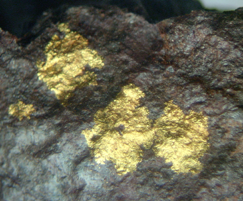


Chispa Gulch, Greaterville placer deposits, Greaterville, Greaterville Mining District, Pima County, Arizona, USA