| Locality type: | Quarry |
| Classification |
|---|
|
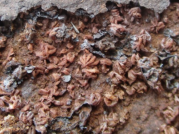
| Species: | Baryte |
| Formula: | BaSO4 |
| Confirmation |
|---|
|
| Validity: | Believed Valid |
| Associated Minerals Based on Photo Data: |
|---|
|
| Smectite Group | ⓘ1 photo of Baryte associated with Smectite Group at this locality. |
| Data |
|---|
|
| Mineral Data: | Click here to view Baryte data |
| Locality Data: | Click here to view Porphyry quarry "Okrzeszyn II", Okrzeszyn, Gmina Lubawka, Kamienna Góra County, Lower Silesian Voivodeship, Poland |
| Data Identifiers |
|---|
|
| Mindat Occurrence Record ID: | 1319059 |
| Long-form Identifier: | 1:3:1319059:8 |
| GUID (UUID V4): | eb3a373b-c439-49b2-bc37-5446f898711c |
| Nearest other occurrences of Baryte |
|---|
|
|
| 12.3km (7.7 miles) | ⓘAnielska Góra rhyolite quarry, Przedwojów, Gmina Kamienna Góra, Kamienna Góra County, Lower Silesian Voivodeship, Poland |
| 15.6km (9.7 miles) | ⓘMelaphyre quarry, Grzędy, Gmina Czarny Bór, Wałbrzych County, Lower Silesian Voivodeship, Poland |
| 16.8km (10.5 miles) | ⓘBorówno melaphyre quarry, Krzeszów, Gmina Kamienna Góra, Kamienna Góra County, Lower Silesian Voivodeship, Poland |
| 17.6km (10.9 miles) | ⓘStary Lesieniec quarry, Stary Lesieniec, Boguszów-Gorce, Wałbrzych County, Lower Silesian Voivodeship, Poland |
| 17.7km (11.0 miles) | ⓘMount Krzywucha, Rybnica Leśna, Gmina Mieroszów, Wałbrzych County, Lower Silesian Voivodeship, Poland |
| 18.5km (11.5 miles) | ⓘMelaphyre quarry, Rybnica Leśna, Gmina Mieroszów, Wałbrzych County, Lower Silesian Voivodeship, Poland |
| 19.3km (12.0 miles) | ⓘKoło, Osiedle Grunwaldzkie, Boguszów-Gorce, Wałbrzych County, Lower Silesian Voivodeship, Poland |
| 19.4km (12.0 miles) | ⓘBoguszów baryte mine, Koło, Osiedle Grunwaldzkie, Boguszów-Gorce, Wałbrzych County, Lower Silesian Voivodeship, Poland |
| 19.6km (12.2 miles) | ⓘLiczyrzepa mine, Podgórze, Kowary, Karkonosze County, Lower Silesian Voivodeship, Poland |
| 19.9km (12.4 miles) | ⓘPodgórze Mine, Podgórze, Kowary, Karkonosze County, Lower Silesian Voivodeship, Poland |
| References |
|---|
|
|


Porphyry quarry "Okrzeszyn II", Okrzeszyn, Gmina Lubawka, Kamienna Góra County, Lower Silesian Voivodeship, Poland