| Locality type: | Mine |
| Classification |
|---|
|
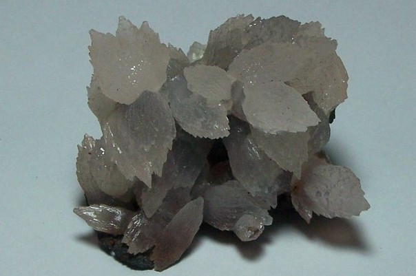
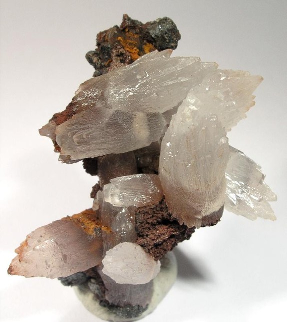
| Species: | Calcite |
| Formula: | CaCO3 |
| Comments: | Crystal groups. |
| Habit: | Scalenohedral |
| Colour: | Delicate pink |
| Confirmation |
|---|
|
| Validity: | Believed Valid |
| Associated Minerals Based on Photo Data: |
|---|
|
| Quartz | ⓘ3 photos of Calcite associated with Quartz at this locality. |
| Malachite | ⓘ3 photos of Calcite associated with Malachite at this locality. |
| Baryte | ⓘ2 photos of Calcite associated with Baryte at this locality. |
| Hematite | ⓘ1 photo of Calcite associated with Hematite at this locality. |
| Stilbite Subgroup | 1 photo of Calcite associated with Stilbite Subgroup at this locality. |
| Data |
|---|
|
| Mineral Data: | Click here to view Calcite data |
| Locality Data: | Click here to view Magma Mine (Magma Superior Mine; Magma Copper Mine), Superior, Pinal County, Arizona, USA |
| Photo Gallery | View Gallery (25 photos) |
| Data Identifiers |
|---|
|
| Mindat Occurrence Record ID: | 43812 |
| Long-form Identifier: | 1:3:43812:4 |
| GUID (UUID V4): | b0b020c3-fa6b-422f-ac48-182e804fdda8 |
| Nearest other occurrences of Calcite |
|---|
|
|
| 0.3km (0.2 miles) | ⓘLake Superior and Arizona Mine (L.S. & A. Mine; Gold Eagle Mine; Golden Eagle Mine; Superior and Arizona Mine; Vivian shaft; Monarch vein; Queen Creek-Magma Mine; Superior Manganese Mine), Superior, Pinal County, Arizona, USA |
| 1.4km (0.9 miles) | ⓘMagma Chief Copper Mine (Magma Chief group of claims; Magma Chief Mine; Patented claims MS 3482; Patented claim MS 3483), Superior, Pinal County, Arizona, USA |
| 3.2km (2.0 miles) | ⓘSilver King Mine, Comstock Wash, Kings Crown Peak area, Pinal County, Arizona, USA |
| 4.0km (2.5 miles) | ⓘResolution deposit, Superior, Pinal County, Arizona, USA |
| 4.1km (2.5 miles) | ⓘBelmont Mine (Belmont Copper property; Goodwin Mine; Monte Carlo claim; Smith lease; Doggs Mine; Lone Star Mine), Belmont Canyon, Apache Leap, Superior, Pinal County, Arizona, USA |
| 4.1km (2.6 miles) | ⓘDaggs group of claims, Belmont Mine (Belmont Copper property; Goodwin Mine; Monte Carlo claim; Smith lease; Doggs Mine; Lone Star Mine), Belmont Canyon, Apache Leap, Superior, Pinal County, Arizona, USA |
| 4.6km (2.9 miles) | ⓘGrand Pacific Mine (Grand Pacific Copper Company property; Grand Pacific claims; Pacific group; Pacific Mine; Climax; Sandal group), Pacific Canyon, Apache Leap, Superior, Pinal County, Arizona, USA |
| 5.3km (3.3 miles) | ⓘQueen Creek Quarry, Pinal County, Arizona, USA |
| 5.4km (3.3 miles) | ⓘMagmatic Copper Mine (Magmatic Copper Company claims; Stacy claims; Lode Star claims), Apache Leap, Superior, Pinal County, Arizona, USA |
| 8.8km (5.5 miles) | ⓘUnnamed wash, adjacent to State Route 177, Superior area, Pinal County, Arizona, USA |
| References |
|---|
|
|


Magma Mine, Superior, Pinal County, Arizona, USA