| Locality type: | Mine |
| Classification |
|---|
|
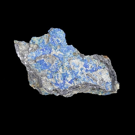
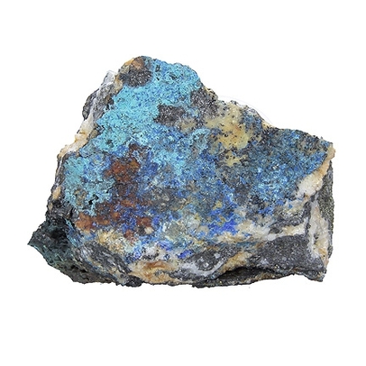
| Species: | Linarite |
| Formula: | PbCu(SO4)(OH)2 |
| Confirmation |
|---|
|
| Validity: | Confirmed |
| Confirmation Methods: | SEM-EDS |
| Associated Minerals Based on Photo Data: |
|---|
|
| Minohlite | ⓘ53 photos of Linarite associated with Minohlite at this locality. |
| Galena | ⓘ52 photos of Linarite associated with Galena at this locality. |
| Chalcopyrite | ⓘ52 photos of Linarite associated with Chalcopyrite at this locality. |
| Quartz | ⓘ52 photos of Linarite associated with Quartz at this locality. |
| Sphalerite | ⓘ52 photos of Linarite associated with Sphalerite at this locality. |
| Data |
|---|
|
| Mineral Data: | Click here to view Linarite data |
| Locality Data: | Click here to view Sunnyside Mine group, Bonita Peak, Gladstone, Eureka Mining District, San Juan County, Colorado, USA |
| Photo Gallery | View Gallery (11 photos) |
| Data Identifiers |
|---|
|
| Mindat Occurrence Record ID: | 1036414 |
| Long-form Identifier: | 1:3:1036414:7 |
| GUID (UUID V4): | 3943bffb-e4c2-42b5-9cdd-414b3b113a0b |
| Nearest other occurrences of Linarite |
|---|
|
|
| 10.7km (6.6 miles) | ⓘOsceola Mine, Cunningham Gulch, Animas Mining District, San Juan County, Colorado, USA |
| 12.9km (8.0 miles) | ⓘTitusville Mine (Columbia; Mighty Monarch), Round Mountain, Silverton, Animas Mining District, San Juan County, Colorado, USA |
| 20.4km (12.6 miles) | ⓘBlack Girl mine, Paquin Mining District, Ouray County, Colorado, USA |
| 20.8km (12.9 miles) | ⓘSenorita Mine, Paquin Mining District, Ouray County, Colorado, USA |
| 21.1km (13.1 miles) | ⓘBandora Mine (Esmeralda claims; Little Todd vein), South Mineral Creek, San Juan County, Colorado, USA |
| References |
|---|
|
|
| Reference Search (possible matching items) |
|---|
 | | Book | | MINES AND MINERALS OF THE GREAT AMERICAN RIFT (COLORADO-NEW MEXICO) Sine —_—< ¢ te om At _SHT 40...MINES AND MINERALS OF THE GREAT AMERICAN RIFT (COLORADO-NEW MEXICO) Richard Walker Holmes and Marrianna...Mines and minerals of the Great American Rift (Colorado-New Mexico). Bibliography: p. Includes index...index. 1. Mines and mineral resources—Colorado. 2. Mines and mineral resources—New Mexico. I. Kennedy, Marrianna...enter must be obtained to prevent trespass. Old mine workings are dangerous and entering underground |  | | Report (issue) | | atemin15cali CALIFORNIA STATE MINING BUREAU FERRY BUILDING, SAN FRANCISCO ^LETCHER HAMILTON State...State Mineralogist [December, 1917 San Francisco] REPORT XV OF THE STATE MINERALOGIST Mines and Mineral...Statement xxiii Participation of the California State Mining Bureau in the Panama-Pacific International Exposition...Production General Features I. Alpine County. 5 6 6 , Mining Districts The Mogul and Monitor Districts...Hercules Company 14 23 Silver Mountain District Silver King District Mineral Water Grover's Hot Springs |  | | Report (issue) | | Thirty-ninth Annual Report of the Mining Industry of Idaho Y_OFS ce For the Year eo or SAR 8 1938...‘ “ve , THIRTY-NINTH ANNUAL REPORT OF THE Mining Industry of Idaho FOR THE YEAR 1937 ARTHUR CAMPBELL...THE IDAHO FORMATIONS LEGEND @-County Seats Custrer-Lte. —-—-County Norzes af Coun tres Boundary...Leon...............-....-----------------------The Mining Industry, by Senator William H. King.............Transportation and Mining, by Edward M. Bryan.....................--------------35 Roads to Mining’ Areas, by |  | | Report (issue) | | IDAHO So THIRTY - THIRD ANNUAL REPORT OF THE Mining Industry of IDAHO FOR THE YEAR 1931 STEWART INSPECTOR...submitted, STEWART CAMPBELL, Inspector of Mines. MINING 6 ARTICLES SPECIAL INDUSTRY APPEARING OF...32d, Bunker Hill & Sullivan M. & C. Co.: Valley County..---.....--.ee WA eee = 25th, ee ee ce ae BE UTS...AUD66 ee Oe ae ee es Dlectricity in Coeur d’Alene District: --...--...--..----...----------------- 30th,...Anaconda Copper Mining Ce.: Phosphate IME in ts. eee Stoping Anaconda Copper Mining Co.: Inclined Top |  | | Report (issue) | | THIRTY-FIRST ANNUAL REPORT OF THE Mining Industry of IDAHO FOR THE YEAR STEWART INSPECTOR CAMPBELL... a e ue THIRTY-FIRST ANNUAL REPORT OF THE Mining Industry of IDAHO FOR THE YEAR 1929 STEWART...HERCULES CUSTOM NEIL tee a ee es ee ANACONDA COPPER MINING Co.: INCLINED ToP SLICE STOPING IDAHO: PORTIAND::...INESWiEOTOTS, OF) SEDEG TAA IVITINGINGC Osteen tees MINE RESCUE. IN) PES CORWR DAU iN IRCCIDENTS) once...ANNUAL A TAG OUND Yi oe. ee ee Eee ot DR ADAMS COUNTY so secce tee ee ee be 1 IBANNOCK. (COUNIVY 3 ce |  | | Report (issue) | | THIRTY -SECOND ANNUAL REPORT OF THE Mining Industry of IDAHO FOR THE YEAR STEWART INSPECTOR CAMPBELL...OF MINES THIRTY -SECOND ANNUAL REPORT OF THE Mining Industry of IDAHO FOR THE YEAR 1930 STEWART INSPECTOR...activities a Bunker Hill & Sullivan M. & C. Co.: Valley County.........-+-+++++-+-:eae 6 t Fo ine oIOks Crate...aa woe RAe hemor (Goviboahhb plant of Sullivan Mining Co........--+-++.++++55 Electrolytic cadmium acca...alent ines INew hoist of Sunshine Mining COm.. ta Sherman Howe Mining Co.......... Bs od gMey a a aDaylcbA |
|


Sunnyside Mine group, Bonita Peak, Gladstone, Eureka Mining District, San Juan County, Colorado, USA