 | | Journal (article/letter/editorial) | | pseudobrookite from Lemolo Lake, Douglas County, Oregon, USA Donald G. Howard and Kent England With 6...a basaltic andesite at Lemolo Lake, Douglas County, Oregon. Multiple twins about a center have been observed...Pseudobrookite twins are present in the vesicles of the same rock. The composition planes observed for psuedobrookite...pseudobrookite; twinning; catalyzed growth; Lemolo Lake, Oregon; Big Lue Mountains, Arizona; The Anakies, Victoria...the Cascade range of Oregon, such as at Summit Rock in extreme western Klamath County (Kleck 1970). Pseudobrookite |  | | Journal (issue) | | Number 8 FALL MEETING ...............HILLSBORO, OREGON November 8, 2003 9:30 am to 5:00 pm Rice NWMuseum...and Minerals 26385 NW Groveland Drive Hillsboro, Oregon '--· We are meeting in a new location. To reach...Micromineral Study Group. He was also active in the Oregon Agate and Mineral Club, and in Friends of Mineralogy...agate and thunder egg locations in the state of Oregon, and for many years was an active participant in...little crystals nestled down in a cavity of the rock. But even more, he loved the people who loved those |  | | Journal (issue) | | WASHINGTON November 16, 2002 9:30 am to 6:30 pm Clark County P. U. D. Building 1200 Fort Vancouver Way Vancouver...horne. There will be ample free material from Summit Rock. N + Morning: Bob Smith will talk and show...Howard will talk and show slides of Summit Rock, Klamath Co_, Oregon. Anyone who has slides to share v...they form, be they water based or some other molten rock. Even our zeolites, such as thomsonite, come in...your successes! l 10. Minerals of Summit Rock, Klamath Co., Oregon Don Howard We have probably all seen |  | | Journal (issue) | | Number 9 SPRING MEETING ............... HILLSBORO, OREGON Saturday, May 1, 2004 9:30 am to 5:00 pm Rice...and Minerals 26385 NW Groveland Drive Hillsboro, Oregon To reach the Rice Museum, take the Sunset Highway...the day. Bring material for the Museum's give-away rock pile as·well as to share with each other. Morning:...Lernolo Lake produced a considerable poundage of rock to examine and contemplate. In going through what...collectors working at the dam. Like Summit Rock, the basic rock used to make the dam at Lemolo Lake is |  | | Journal (issue) | | G. Howard, editor 356 SE 44th Avenue Portland, Oregon, 97215 e-mail: pogodh@hei.net DUES: $15 per year...“Kelly” Starnes 1276 SE Goodnight Avenue Corvallis, Oregon, 97333 e-mail: bikeklein@yahoo.com Zeolite Group...sedimentary rock and some of the minerals associated with it. Another major classification of rock types is...of igneous environments, based on how slowly the rock manages to cool initially. Eruptive episodes usually...Cliffs, Lane Co., Oregon Fig. 3. Laihunite and Osumilite Obsidian Cliffs, Lane Co., Oregon 6 Fig. 4, Filiform |  | | Journal (issue) | | WASHINGTON November 4, 2006 9:30 am to 5:00 pm Clark County P. U. D. Building 1200 Fort Vancouver Way Vancouver...Way Washington Interstate Bridge Columbia River Oregon 2 The Bagdad Chase Mine, San Bernardino Co....producer of both gold and copper in San Bernardino County over the years. At one time, a spur railroad was...only a few miles you come across large piles of rock fragments. This is one area that we spent some time...mimetite and wulfenite. This was found in a single rock on the pile during a previous trip. Another unusual | 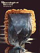 | | Journal (issue) | | R. Kampf Natural History Museum of Los Angeles County Arthur Roe Tucson, AZ Abraham Rosenzweig University...Urals, Soviet Union; the Morefield mine, Amelia County, Virginia; and the Anjanabonoina pegmatite in Madagascar...unweathered, is enclosed within mica schist country rock and consists of milky quartz, abun dant muscovite...topaz, and small amounts of phenakite, tantalite, zircon and fergusonite. Ferraz (1929) also observed dark...greenish feldspar border the pegmatites in the wall rock. Gem-quality emerald, associated with sparse phenakite |  | | Journal (article/letter/editorial) | | 1329 Arizona Economic geology Aluminum, Maricopa county, Wickenberg (Sheridan, Michael F , et al.) tt-t2...(Mclean, W. John, er a/.) 7-E 1103 Hemihedrite,Pinal county, Florencemine, Maricopacounty, Wickenburg,Rat Tail...a/.) 7-8 1088 Kinoite, SantaRita mountains,Pima county (Anthony, John W., er a/.) 5-6 7O9 Phoenicochroite...and steam in Sl-units 9'10 1822 (Schmidt, Ernst.) Rock and mineral analysis 7-E 1453 (Maxwell, J. A.) ...er a/.) 1.2 224 Breccia Intrusive Utah, San Juan county, MosesRock dike, kimberlite (McGetchin, Thomas |  | | Report (issue) | | STATE OF OREGON DEPARTMENT OF GEOLOGY AND MINERAL INDUSTRIES 1005 State Office Building Portland, Oregon...BIBLIOGRAPHY OF THE GEOLOGY AND MINERAL RESOURCES OF OREGON Seventh Supplement January 1, 1976, to December...Geological Institute Debbie Burnetti, Editor and Oregon Department of Geology and Mineral Industries Klaus................ ............. .. iii Map showing Oregon counties . . . . . . . . . . . . . . . . . . ..... . . . . . . . . . . . . . . . . . .. . .. 25 County index . . . . . . . . . . . . . . . . . . . |  | | Journal (issue) | | Korowski and C. W. Notebart Quartz & Pyrite from King County, Washington......................................388 by H. Barwood and B. Hajek Zircons of Summit Rock, Oregon............................................encountered in the Hangingwall argil lite. The host rock has since been largely removed as waste during continuing...pits. It is a fine-grained, medium to dark grey rock, which is hard and difficult to work, if unweathered...more easily cleaved parallel to the bedding. The rock is composed of fine-grained quartz, microcline and |  | | Journal (article/letter/editorial) | | the Topopah Spring Tuff at Yucca Mountain, Nevada, USA R. J. MOSCATI* AND C. A. JOHNSON U.S. Geological...Federal Center, Box 25046, MS 963, Denver, CO 80225, USA [Received 20 January 2014; Accepted 10 April 2014;...normative mineralogy, accounting for 96.5% of the rock, of quartz, orthoclase and plagioclase (mostly albite)...spectrometric analyses indicated that in rare cases, zircon and R. J. MOSCATI AND C. A. JOHNSON al., 2002)...within these tridymite inclusions. The presence of zircon indicates that the vapour also contained minor |  | | Journal (issue) | | FALL, 2005 FALL MEETING ...............HILLSBORO, OREGON Saturday, November 5, 2005 9:30 am to 5:00 pm...and Minerals 26385 NW Groveland Drive Hillsboro, Oregon Once again we will be meeting in the NW Gallery...Minerals from the Bald Mountain Skarn, Jefferson County, Montana Larry B. French HC 46. Box7204 Miles City...Howard, Editor 356 S. E. 44th Avenue Porfland, oregon 97215 e-mail: pogoette@hei.net DUES: $15 per year...Secretary-Treasurer: Don Lown 80770 Turkey Run Rd Creswell, oregon, 97426 e-mail: donlown@earthlink.net EDAX, the |  | | Catalog/List | | tufts ACTINOLITE: Bull Run Quarry, Loudon County, Virginia, USA. sprays and tufts ACTINOLITE,variety AMIANTHUS:Steintal...ACTINOLITE,variety BYSSOLITE: French Creek, Pennsylvania, USA. sprays and tufts ACTINOLITE SMARAGDITE:Micciano...crystals ADAMITE,variety CUPROAN:Gold Hill, Utah, USA. crystals AEGERINE: Kola Peninsula, USSR. crystal...AFWILLITE: Crestffiore Quarry, Riverside, California, USA. massive AGRELLITE: KipawQ River, Villodieu Township...ALABANDITE:Tombstone. Arizona, USA. massive ALBERTITE(HYDROC,\RBONl: Prince Albert County. Nova Scotia, massive |  | | Report (issue) | | abundance as percent of rock sample ("Phenocrysts 30" means that 30 percent of the rock consists of phenocrysts)...vesicular lavas interbedded with cinders and bombs. Rock locally contains sparse small (0.5 mm) phenocrysts...the only visible mafic minerals in the devitrified rock; pyroxene and hornblende are the only visible mafic...unit. Although the rock in all localities looks very similar in outcrop, the rock east of Marble Creek...the rock exposed north of Dynamite Creek contains more alkali feldspar than plagioclase. The rock in both |  | | Report (issue) | | Geologic Map of the Clayton Quadrangle, Custer County, Idaho Description of map units By S. W. Hobbs...Ql YOUNG LANDSLIDE DEPOSITS (HOLOCENE) Mass of rock material in source area displaced relatively short...silt, and sand-sized material but including small rock fragments and some angular cobble- and bouldersized...as locally thick fill-terraces and gravel-capped rock-cut terraces along main Salmon River whose tops...100 feet (31 m) above present river level. Higher rock-cut terraces and thick fill-terraces probably Pleistocene |  | | Book (edition) | | abbreviations: Rep. (republic), prov. (province), co. (county), munic. (municipio), pref. (prefecture), dept...always included in text, except in the cases of the USA, UK, and the provinces Ontario and Quebec in Canada...Uintah County. Utah. and m (2.B. acanthite group). Monoclinic, C2/m, a,b,c Rio Blanco County. Colorado...vitreous to Hot Springco., Arkansas, in the Point of Rock quarry, pearly. Clea,·age {001} perfect. {100} and...Plat., Malawi, G 10 17 River Formation in Uintah County, Utah. Deer et al., v. 2A,483, 1997. Aenigmatite |  | | Journal (article/letter/editorial) | | AETICLBS. I.—FULGURITES FROM TUPUNGATO AND THE SUMMIT OF ACONCAGUA. By Professor T. G. BONNEY, D.SC...Andes in 1896-7' made a rather large collection of rock specimens from the higher regions, which has been...remarkably fine fulgurites, taken from the actual summit of Tupungato (20,260 feet) by Mr. S. M. Vines,...the top of highest of the three heaps or peaks at summit of Tupungato." It is a block rather irregular in...older surfaces (some being fresh fractures). The rock is compact, except for a few minute vesicles; in |  | | Book | | a l s 1 8 chapter 4 T h e Rock Cycle 22 PART II Minerals from Molten Rock 28 chapter 5 Crystallization...materials are? How can I tell that one particular rock or mineral must have formed in an I0 ancient...Witnessing lava cool before our eyes to form solid rock provides the direct evidence we need to infer a..."float" they would have to be less dense than the rock beneath them. This is exactly the case. Although...from the sudden release of energy and fracturing of rock as the plates slide by one another. The third case |  | | Report (volume) | | Volcanic Subsidence in the Custer Graben, Custer County, Idaho, by D. H. Mclntyre and K. M. Johnson. 109...in the southwest to a high of 11,815 ft at the summit of Castle Peak in the White Cloud Peaks (fig. A2)...Atlanta lobe of the Idaho batholith is composed of six rock types emplaced in at least three stages during a...which together make up as much as 35 percent of rock IDAHO BATHOLITH AND RELATED ROCKS CEOUS) Granitic... Biotite may constitute as much as 2 percent of rock. Garnet is common. Occurs as dikes and irregular |  | | Journal (article/letter/editorial) | | Brookins, D. G. Metastibnite from The Geysers, Sonoma county, California Brown, F. H. Zoning in some volcanic...beta-Be(OH)1, from the Rode Ranch pegmatite' Llano county, Texas Einaudi. Marco T. An iron-sensitive stain...earths, and color centers in a crystal of natural zircon Finger, L. lil. The structure reflrnementand cation...u d y of pentlandite Huang, W. H. Dissolution of rock-forming silicate minerals in organic acids; simulated...Joseph Leon Rosenholtz Keller, W. D. Dissolution of rock-forming silicate minerals in organic acids; simulated |  | | Report (issue) | | ........................................... 183 Rock products, by Frederick S. Fisher and S. Warren Hobbs...I°x2° quadrangle showing major units of c^bonate rock ten^e.............................................described here. This report considers all mineral and rock commodities known or suspected to occur within the...in the southwest, to a high of 11,815 ft at the summit of Castle Peak in the White Cloud Peaks (pi. 1)...Alluvial terrane Trans -Challis fault system terrane Rock products: Quartzite (flagstone) Granite (building |  | | Report (volume) | | Late Mesozoic conglomeratic flysch in southwestern Oregon, and the problem of transport of coarse gravel...measurements of the Miocene geomagnetic field in Oregon: Pure and Appl. Geophysics, v. 82, p. 189-221,...Toshihisa. Construction of continuum theories for rock by tensor testing [abs.]: Dissert. Abs. Internat...of rocks, Chap. 18 in Rock mechanics, theory and practice - 11th Symposium on Rock Mechanics, Berkeley... George G. The Metaline district, Pend Oreille County, Washington, [Chap.] 6 in Lead-zinc deposits in | 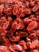 | | Journal (issue) | | R. Kampf Natural History Museum of Los Angeles County George Robinson National Museums of Canada Arthur...Vanadinite from the J. C. Holmes claim, Santa Cruz County, A rizona........................................currence. Sometimes a village or township and a county, or a village and a state have the same name and...hap pens that the village or city is not in the county of the same name nor even in the state. For example...minerals. Chester is also a large city in Delaware County. We have frequently run across minerals from Chester |  | | Journal (article/letter/editorial) | | have examined ths very interesting collection of rock ' freaks' (if such a term be permitted) at the British...masked a real brightness, and the mineral was a dark zircon. One or two grains of a ratber granular dull yellow...the casts of three cup-like depressions, and a "summit view of a group of casts of the cup-like depressions...Collie also obtained four specimens of darkish slaty rock, all probably more or less calcareous, and one which...the latter being more altered than is usual in a rock belonging even to the later part of the Cambrian |  | | Journal (volume) | | Telluride, Col., Journal says that a good, hard-rock to lie idle a moment longer than he deThe Smuggler...Creek, good miners are in demand in San Miguel county. W. H. BL'sn, of Denver, has a big scheme to run...printed list that in '95 to December 22 in Lake county 1493 mineral locations were made, more than double...was denied them in the District Court in Shoshone county. The Supreme Court reversed it, and a petition...large, cut through it at right angles, throwing the rock from the trench thus made in a pile by itself. This |
|


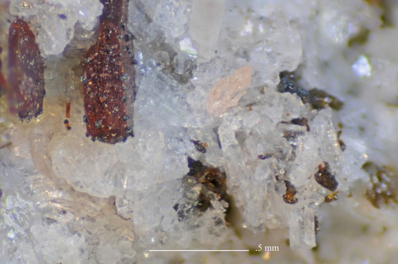


Summit Rock, Klamath County, Oregon, USA