| Locality type: | Quarry |
| Classification |
|---|
|
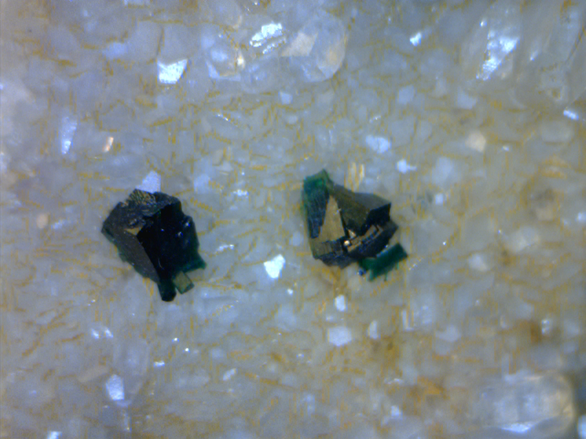
| Species: | Malachite |
| Formula: | Cu2(CO3)(OH)2 |
| Confirmation |
|---|
|
| Validity: | Believed Valid |
| Data |
|---|
|
| Mineral Data: | Click here to view Malachite data |
| Locality Data: | Click here to view Farmers Cooperative Limestone Quarry, New London, Frederick County, Maryland, USA |
| Data Identifiers |
|---|
|
| Mindat Occurrence Record ID: | 201986 |
| Long-form Identifier: | 1:3:201986:4 |
| GUID (UUID V4): | 5295a300-35bd-445c-a5ef-768adb88896c |
| Nearest other occurrences of Malachite |
|---|
|
|
| 2.3km (1.4 miles) | ⓘNew London Mine (Linganore Mine), New London, Frederick County, Maryland, USA |
| 6.5km (4.0 miles) | ⓘHammond Prospect (Pittinger Prospect), Frederick County, Maryland, USA |
| 7.3km (4.5 miles) | ⓘDolyhyde Mine (Dolly Hyde Mine), Libertytown, Frederick County, Maryland, USA |
| 7.7km (4.8 miles) | ⓘLiberty Mine, Libertytown, Frederick County, Maryland, USA |
| 8.1km (5.0 miles) | ⓘUnionville Mine, Frederick County, Maryland, USA |
| 12.1km (7.5 miles) | ⓘRepp Mine, Frederick County, Maryland, USA |
| 16.5km (10.2 miles) | ⓘUnion Bridge Quarry & Cement Plant (Lehigh Portland Cement Company; Union Bridge Shale Pit), Union Bridge, Carroll County, Maryland, USA |
| 16.9km (10.5 miles) | ⓘWilliam Carbaugh's Quarry, New Windsor, Carroll County, Maryland, USA |
| 18.1km (11.2 miles) | ⓘCox Mines (Mountain View Mine), Frederick County, Maryland, USA |
| 19.3km (12.0 miles) | ⓘRobert D. Repp Prospect (Portland Cement Company), Carroll County, Maryland, USA |
| References |
|---|
|
|
| Reference Search (possible matching items) |
|---|
 | | Report (issue) | | ^ Anne Arundel County 43 Baltimore County 45 Howard County - Montgomery County 88 Prince Georges...Georges County Virginia 74 . 120 129 Arlington County 129 Fairfax County 131 Fauquier County 139...139 Loudoun County 143 Prince William County 149 Diabase quarries of northern Virginia 155 CAPTIONS...of the Baltimore Gabbro Complex at Ilchester, Maryland. Figure 6. Triassic diabase dike forming a ridge...Arundel, Prince George's/and Baltimore Counties, Maryland (Sterrett, 1911). Figure 9. Distribution of |
|


Farmers Cooperative Limestone Quarry, New London, Frederick County, Maryland, USA