| Classification |
|---|
|
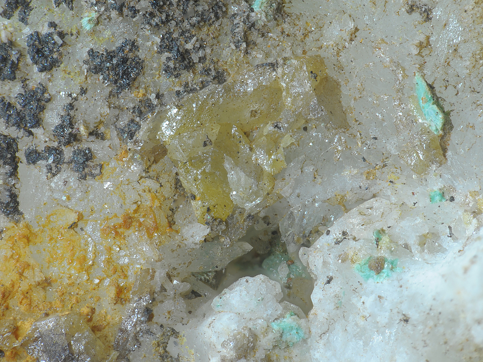
| Species: | Wulfenite |
| Formula: | Pb(MoO4) |
| Confirmation |
|---|
|
| Validity: | Believed Valid |
| Associated Minerals Based on Photo Data: |
|---|
|
| Malachite | ⓘ1 photo of Wulfenite associated with Malachite at this locality. |
| Cerussite | ⓘ1 photo of Wulfenite associated with Cerussite at this locality. |
| Data |
|---|
|
| Mineral Data: | Click here to view Wulfenite data |
| Locality Data: | Click here to view Prospect above Augustin adit, Rauriser Goldberg, Kolm-Saigurn, Alteck - Hoher Sonnblick area, Rauris, Zell am See District, Salzburg, Austria |
| Photo Gallery | View Gallery (2 photos) |
| Data Identifiers |
|---|
|
| Mindat Occurrence Record ID: | 1462016 |
| Long-form Identifier: | 1:3:1462016:6 |
| GUID (UUID V4): | 703fcaf8-dba8-4b76-94f3-4421130dc8c5 |
| Nearest other occurrences of Wulfenite |
|---|
|
|
| 0.7km (0.4 miles) | ⓘSlag localities, Kolm-Saigurn, Alteck - Hoher Sonnblick area, Rauris, Zell am See District, Salzburg, Austria |
| 1.7km (1.1 miles) | ⓘLeidenfrost, Hoher Sonnblick, Alteck - Hoher Sonnblick area, Rauris, Zell am See District, Salzburg, Austria |
| 2.3km (1.4 miles) | ⓘNorth face, Hoher Sonnblick, Alteck - Hoher Sonnblick area, Rauris, Zell am See District, Salzburg, Austria |
| 2.8km (1.7 miles) | ⓘKELAG water tunnel, Großkirchheim, Spittal an der Drau District, Carinthia, Austria |
| 3.8km (2.4 miles) | ⓘGold mine (Goldzeche), Zirmsee area, Heiligenblut am Großglockner, Spittal an der Drau District, Carinthia, Austria |
| 4.4km (2.7 miles) | ⓘRoter Mann, Heiligenblut am Großglockner, Spittal an der Drau District, Carinthia, Austria |
| 6.0km (3.7 miles) | ⓘSchleierfall tunnel, Naßfeld valley, Bad Gastein, St. Johann im Pongau District, Salzburg, Austria |
| 6.5km (4.1 miles) | ⓘTorleiten (incl. Feldseescharte), Wurten, Flattach, Spittal an der Drau District, Carinthia, Austria |
| 7.2km (4.5 miles) | ⓘLohning quarry (Lohninger quarry), Rauris, Zell am See District, Salzburg, Austria |
| 8.3km (5.1 miles) | ⓘKaiserer quarry (Deisl quarry), Rauris, Zell am See District, Salzburg, Austria |
| References |
|---|
|
|


Prospect above Augustin adit, Rauriser Goldberg, Kolm-Saigurn, Alteck - Hoher Sonnblick area, Rauris, Zell am See District, Salzburg, Austria