 | | Journal (issue) | | February 1987 No.1 VIRGINIA MINERAL LOCALITY INDEX D. Allen Penick, Jr. This Virginia mineral locality...world-wide locality index The localities are listed by county, followed by a listing of the most prominent minerals...source of information in this Virginia index was Minerals of Virginia (1970) by R. V. Dietrich. Although...of the index. Some of the famous localities in Virginia, such Updated from Rocks and Minerals, Vol. 60...pegmatite in Amelia County and the Lynch Station locality (turquoise crystals) in Campbell County, are now closed |  | | Journal (article/letter/editorial) | | VIRGINIA MINERAL LOCAL INDEX Although perhaps best known for its turquoise crystals, apophyllite on...kyanite, Virginia has, in fact, over 150 mineral species. and D. A L L E N P E N I C K , JR. Virginia Division...Mineral Resources P. O. Box 3667 Charlottesville, Virginia 22903 T H I S V I R G I N I A M I N E R A L L...world-wide locality index. The localities are listed by county, followed by a listing of the most prominent minerals...source of information in this Virginia index was Minerals of Virginia (1970) by R . V . Dietrich. A l |  | | Journal (article/letter/editorial) | | Bull Run Quarry Loudoun County, Virginia H O W A R D R. F R E E L A N D 10340 Hollyberry Drive Richmond...Richmond, Virginia 23234 Most collectors are familiar with fine prehnite, apophyl lite, and zeolite specimens...Narsavage, 1977), and at the Fairfax quarry near Centreville, Virginia (Medici, 1972; Mitchell, 1977). There...are several other "trap" quarries in northern Virginia which have yielded beautiful and sometimes rare...environments. Bull Run quarry located in Loudoun County, Virginia, is one such quarry. To date, nearly |  | | Report (issue) | | ^ Anne Arundel County 43 Baltimore County 45 Howard County - Montgomery County 88 Prince Georges...Georges County Virginia 74 . 120 129 Arlington County 129 Fairfax County 131 Fauquier County 139...139 Loudoun County 143 Prince William County 149 Diabase quarries of northern Virginia 155 CAPTIONS...forming a ridge north of Route 7 near Dranesville, Virginia. Figure 7. Locations of mineral deposits in...mines in the Soldiers Delight region, Baltimore County, Maryland. Adapted from Pearre and Heyl , 19.60 |  | | Report (issue) | | the cover—Turquois crystals from Lynch Station, Virginia; x ca.; pho tograph by Neal Ycdlin; color plates...C. A. Michael. COLD NUGGET FROM SPOTSYLVANIA COUNTY: Longest dimension approximately 13 cm., photograph...of Virginia R. V. DIETRICH* Professor of Geology and Associate Dean of Arts & Sciences, Virginia Polytechnic...Polytechnic Institute Research Division Bulletin 47 Virginia Polytechnic Institute, Blacksburg, Va. 24061 *... © R. V. Dietrich and the Research Division of Virginia Polytechnic Institute, 1970 Printed and bound |  | | Journal (issue) | | the Virginia Polytechnic Institute, Engineering Experiment Station Series, dealing with Virginia Mineral...Mineral Localities: Virginia Mineral Localities (1960 Edition) Virginia Mineral Localities (Supplement...(Supplement I) Virginia Mineral Localities (Supplement II) Virginia Minerals and Rocks (3rd Edition) Ex LIBRIS...\I i! II II BULLETIN OF THE ·, I !V I ii VIRGINIA POLYTECHNIC INSTITUTE Engineering Experiment Station...Series No. 151 Ii !I ·1 " ii :c H I I I I ! VIRGINIA MINERAL LOCALITIES ( SUPPLEMENT II ) By Richard |  | | Journal (article/letter/editorial) | | VIRGINIA MINES AND MINERALS By P H I L I P M O R R I L L East D e r r y , N . H . 0 3 0 4 1 (PART INTRODUCTION...mines in Virginia, north of the James River, with the ex ceptions as follows: Albemarle County was very...northern Virginia. Maps used were the U.S.G.S. Topo graphical Sheets. Also used were the county road maps...of H i g h w a y s Richmond, Virginia The price is 2 0 cents per county. Other states could well follow...very high grade iron. Credit should be given the Virginia Department of Mineral Resources in Charlottesville |  | | Book | | for naming stilbite, analcime, harmotome, and laumontite although he only popularized and more completely...faujasite, ferrierite, gmelinite, goosecreekite, laumontite, levyne, mazzite, merlinoite, montesommaite,...pressure collapses. At high pressure heulandite or laumontite is replaced by lawsonite, and analcime by albite...scattered sites. Rarely, erionite, mordenite, and laumontite are found. Merlinoite is found with plagioclase...Lower Miocene columnar basalt in the Narre Warren Quarry, near Melbourne, Australia. The minerals are believed | | | Book | | for naming stilbite, analcime, harmotome, and laumontite although he only popularized and more completely...faujasite, ferrierite, gmelinite, goosecreekite, laumontite, levyne, mazzite, merlinoite, montesommaite,...pressure collapses. At high pressure heulandite or laumontite is replaced by lawsonite, and analcime by albite...scattered sites. Rarely, erionite, mordenite, and laumontite are found. Merlinoite is found with plagioclase...Lower Miocene columnar basalt in the Narre Warren Quarry, near Melbourne, Australia. The minerals are believed |  | | Journal (issue) | | the Month for April. Some of us have found it in Virginia, and more of us can seek it when we return to...little-known facts about this mineral. Northern Virginia Mineral Club members, No in-person social events...Newsletter Prehnite, O&G Southbury Quarry, Southbury, New Haven County, CT. Photo: Bob Cooke. the specimens...through many shades of green. The Upper New Street Quarry was active from 1893 to 1925, although specimens...Prospect Park Quarry, Paterson, NJ. Bottom: Prehnite with babingtonite, Roncari Quarry, East Granby, |  | | Report (issue) | | and C.M. Sears U.S. Geological Survey Reston, Virginia 22092 Open-File Report 92-448 This report is...Site Number, Site Name ...................... 6 County, State, Quadrangle, Latitude, Longitude .........Occurrences located in the Culpeper basin, Maryland and Virginia ..................... 168 H. Section H: Occurrences...Occurrences located in other areas of Virginia. ... 185 I. Section I: Occurrences located in North Carolina...given in the categories of : 1. name and location ( county, state, quadrangle, latitude, and longitude) 2 |  | | Report (volume) | | assachusetts, Connecticut, New jersey, Pennsylvania, Virginia , Maryland , North Carolina, and other Eastern...Massachusetts, Connecticut, New Jersey, Pennsylvania, Virginia, Maryland , North Carolina, and South Carolina...appropriate, the applicable early Mesozoic basin, State, county, or 7 1/2minute USGS topographic quadrangle covered...the State are cited. More than one basin, State, county, or quadrangle may appear for an entry. A State...C.-S.C.) Deep River (N.C.) Durham (N.C.) Davie County (N.C.) Dan River and Danville (N.C.-Va.) Scottsburg |  | | Book (volume) | | chalcedony, jasper and gem petrified wood. BUFFALO COUNTY KEARNEY, area gravel bars and pits along the Platte...petrified wood. CASS COUNTY WEEPING WATER, SE, on rd. to Nehawka, in the Snyderville Quarry chalcedony, jasper...jasper, fossils. CHERRY COUNTY VALENTINE, in the Sandhills county along the Niobrara R. and Minnechaduza...gem qualityagatized and opalized wood. DAWES COUNTY CHADRON, in N part of Co. and as far W as Crawford...woods, etc. DAWSON COUNTY GOTHENBURG, in sand pitspetrified palm wood. DEUEL COUNTY CHAPPELL, all regional |  | | Book (volume) | | the western counties, especially the Clay Center Quarry 12 miles southeast of Toledo but in Ottawa Co....ASHTABULA COUNTY CONNEAUT, area pits, quarries, rd. cuts, etc.⎯cone-in-cone Calcite. CLERMONT COUNTY MILFORD...CLINTON COUNTY WILMINGTON, area of Todd’s Ford, a mineral deposit⎯Hematite. COSHOCTON COUNTY AREA, townships...townships of Washington, Virginia, Bedford, Jackson, Jefferson, Bethlehem, Monroe and Clark; on regional...CUYAHOGA COUNTY CHAGRIN FALLS (on Geauga Co. line), area quarries⎯oilstone. DELAWARE COUNTY DELAWARE |  | | Book (volume) | | the western counties, especially the Clay Center Quarry 12 miles southeast of Toledo but in Ottawa Co....ASHTABULA COUNTY CONNEAUT, area pits, quarries, rd. cuts, etc.⎯cone-in-cone Calcite. CLERMONT COUNTY MILFORD...CLINTON COUNTY WILMINGTON, area of Todd’s Ford, a mineral deposit⎯Hematite. COSHOCTON COUNTY AREA, townships...townships of Washington, Virginia, Bedford, Jackson, Jefferson, Bethlehem, Monroe and Clark; on regional...CUYAHOGA COUNTY CHAGRIN FALLS (on Geauga Co. line), area quarries⎯oilstone. DELAWARE COUNTY DELAWARE |  | | Journal (issue) | | minerals. Of the seven zeolite mi nerals identified, laumontite and heu landite occur most frequently. Calcite...minerals (analcime, epistilbite, heulandite, laumontite, mordenite. scolecite, and stilbite/stellerite)...ill cuttings from the SUNEDCO 58-28 drill hole; laumontite and heulandite occur most frequently (Figure...02- Analcime. in association with heulandite, laumontite, smectite(?), and halloysite, was identified...composite zeolite chips at 716-780 m. Analcime (plus laumontite, heulandite, and smectite) was found in two altered |  | | Book (volume) | | 600 to 800 feet thick in the north. ALEXANDER COUNTY FAYVILLE, area stream gravels⎯agate, jasper, rare...⎯agate, jasper; d RR siding of Clay⎯agate. CALHOUN COUNTY AREA, shores of the Mississippi R., in the Warsaw...crystals). CRAWFORD COUNTY PALESTINE, area deposits⎯Siderite. EDWARDS COUNTY AREA, T. 1 S, R. 10 E...E, regional deposits⎯Siderite. FULTON COUNTY FARMINGTON, W 6 mi. on Rte. 116 to the Rapatee No. 5 strip...mine⎯pyritized gastropods (Pennsylvanian age). GRUNDY COUNTY AREA: c Regional rd. and RR cuts and banks of Mason |  | | Book (volume) | | 600 to 800 feet thick in the north. ALEXANDER COUNTY FAYVILLE, area stream gravels⎯agate, jasper, rare...⎯agate, jasper; d RR siding of Clay⎯agate. CALHOUN COUNTY AREA, shores of the Mississippi R., in the Warsaw...crystals). CRAWFORD COUNTY PALESTINE, area deposits⎯Siderite. EDWARDS COUNTY AREA, T. 1 S, R. 10 E...E, regional deposits⎯Siderite. FULTON COUNTY FARMINGTON, W 6 mi. on Rte. 116 to the Rapatee No. 5 strip...mine⎯pyritized gastropods (Pennsylvanian age). GRUNDY COUNTY AREA: c Regional rd. and RR cuts and banks of Mason |  | | Book (volume) | | beds, excavations, etc.Selenite roses. BRULE COUNTY AREA: in the Oacoma zone of the Pierre Fm. On Elm...gray Barite rosette up to 5 or 6 inches. CAMPBELL COUNTY MOUND CITY, W to the Missouri R., regional hillsides...gravels, etc.petrified wood, wood opal. CORSON COUNTY LITTLE EAGLE: area ridges, slopes, stream beds...Guide for Rock Hounds in the United States CUSTER COUNTY AREA: The November Mine, 1.2 mi. SE of the Needles...minesColumbite, Gold, Silver, etc.; and (2) Old Marble Quarry on the Needles Hwy. 5.5 mi. NEScheelite, and deep |  | | Book | | MineralogicalRecord.com I IIMORIITE-(Y) EUROPE FRANCE Trimouns quarry, Luzenac, Ariege. Operated for talc since the beginning...beginning of the 20th century, the Trimouns quarry became well known to collectors around 1990 for the...long (Marty, 2004 ). AFRICA widely in Litchfield County, where good crystals were taken from quartz veins...region (Brunet, I 977b ). NEW YORK Amity, Orange County. At many isolated collected sites between the towns...Litchfield County. Ilmenite masses and crystals from somewhere near Washington, Litchfield County, were described |  | | Report (issue) | | fillings consist of calcite, chalcedony, stilbite, laumontite, hematite, montmorillonite, magnetite, quartz...calcite, chalcedony, hematite, montmorillonite, laumontite, stilbite, heulandite, chlorite, mordenite, pyrite...several zeolite minerals: epistilbite, heulandite, laumontite (Fig. 4), mordenite (Fig. 5), and stilbite (Fig...below 731.5 m in the Pucci drill hole, except for laumontite, quartz and chlorite, could have formed at the...temperature of the present geothermal regime. Even laumontite could conceivable have formed at the temperature |  | | Report (issue) | | nomenclature in the Big Hatchet Mountains, Hidalgo County, New Mexico, by Augustus K. Armstrong and Bernard...Hoko River, Makah, and Pysht Formations, Cla11am County, Washington, by Parke D. Snavely, Jr., Alan R....Mississippian strata of the Big Hatchet Mountains, Hidalgo County, southwestern New Mexico .................... Map...of the Sandy Springs Group ................... County outline map of part of Georgia showing known outcrop...Makah Formations in their type localities, Clallam County, Washington ................ Map showing area of |  | | Book | | are reported by county of occurrence. Map 1-2 shows the county boundaries and county names. When possible...,o Map 1-2. Outline map of California showing county boundaries. __ _) 4 MINERALS OF CALIFORNIA...in placers of the Potholes District of Imperial County, near the Colorado River about 10 miles north of...reported from San Ysidro, San Diego County, in 1828 ; from Los Angeles County, San Francisquito Canyon, in 183...183 5; and in the Piru District, Ventura County, in the early 1840s. Then in 1848 the discovery of gold |  | | Report (volume) | | ............................................. Virginia......................................................................................... West Virginia.................................................minerals of the United States: U. S. Geol. Survey Bull. 585, 1914. 5 6 USEFUL MINERALS OF THE UNITED...Minerals of California: California State Min. Bur. Bull. 67, 1914. George, R. D., Common minerals and rocks...occurrence and uses: Colorado State Geol. Survey Bull. 6, 1913. 8 USEFUL MINERALS OF THE UNITED STATES | | | Book | | species are reported by 1-2 shows the county boundaries and county names. When possible, locations of mines...within a township is illustrated by Figure 1-1. county of occurrence. Map *M. Fleischer’s 1980 Glossary...Map 1-2. Outline map of California showing county boundaries. 4 MINERALS OF CALIFORNIA R5W i...first District of Imperial Yuma, Diego County, County, near the Colorado River about 10 miles north...San Ysidro, San Arizona. 1828; from Los Angeles County, San Francisquito Canyon, in in Then in on the |
|


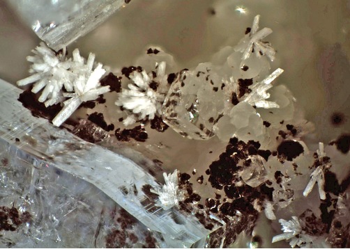


Bull Run Quarry, Conklin, Loudoun County, Virginia, USA