| Locality type: | Quarry |
| Classification |
|---|
|
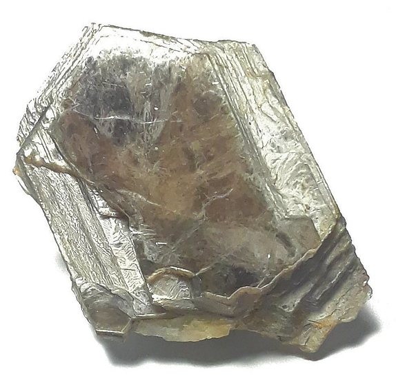
| Species: | Muscovite |
| Formula: | KAl2(AlSi3O10)(OH)2 |
| Comments: | Besides subhedral material in the pegmatite matrix, mostly found around the edges of quartz core "pods" where they can be subhedral and up to 7-8 cm and 1-2 cm thick, rarely found as euhedral, thicker books in pockets. |
| Habit: | tabular, mostly subhedral |
| Colour: | silver to rum |
| Confirmation |
|---|
|
| Validity: | Believed Valid |
| Associated Minerals Based on Photo Data: |
|---|
|
| Albite | ⓘ10 photos of Muscovite associated with Albite at this locality. |
| Schorl | ⓘ4 photos of Muscovite associated with Schorl at this locality. |
| Beryl | ⓘ2 photos of Muscovite associated with Beryl at this locality. |
| Columbite-(Fe) | ⓘ2 photos of Muscovite associated with Columbite-(Fe) at this locality. |
| Quartz | ⓘ2 photos of Muscovite associated with Quartz at this locality. |
| Almandine | ⓘ1 photo of Muscovite associated with Almandine at this locality. |
| Smoky Quartz | ⓘ1 photo of Muscovite associated with Smoky Quartz at this locality. |
| Microcline | ⓘ1 photo of Muscovite associated with Microcline at this locality. |
| Cookeite | ⓘ1 photo of Muscovite associated with Cookeite at this locality. |
| Data |
|---|
|
| Mineral Data: | Click here to view Muscovite data |
| Locality Data: | Click here to view State Forest Quarry No. 1 (State Forest #1 Quarry; Clark Hill Quarry), East Hampton (Chatham), Middlesex County, Connecticut, USA |
| Photo Gallery | View Gallery (6 photos) |
| Data Identifiers |
|---|
|
| Mindat Occurrence Record ID: | 478137 |
| Long-form Identifier: | 1:3:478137:0 |
| GUID (UUID V4): | d91f530a-4795-42fb-8735-314bc57f9fdb |
| Nearest other occurrences of Muscovite |
|---|
|
|
| 0.2km (0.1 miles) | ⓘNathan Hall Quarry (Clark Hill Quarry), East Hampton (Chatham), Middlesex County, Connecticut, USA |
| 0.5km (0.3 miles) | ⓘClark Hill prospect, East Hampton (Chatham), Middlesex County, Connecticut, USA |
| 2.1km (1.3 miles) | ⓘGreat Hill cobalt mines, Cobalt, East Hampton (Chatham), Middlesex County, Connecticut, USA |
| 2.6km (1.6 miles) | ⓘState Forest Quarry No. 2 (State Forest #2 Mica Mine; Carini Quarry), Cobalt, East Hampton (Chatham), Middlesex County, Connecticut, USA |
| 2.8km (1.7 miles) | ⓘSynnott Quarry, Portland, Middlesex County, Connecticut, USA |
| 2.9km (1.8 miles) | ⓘPenfield Quarry (Oak Leaf Quarry), Portland, Middlesex County, Connecticut, USA |
| 3.0km (1.9 miles) | ⓘPelton's Quarry, Portland, Middlesex County, Connecticut, USA |
| 3.2km (2.0 miles) | ⓘGreat Hill Pond Brook pegmatite, Cobalt, East Hampton (Chatham), Middlesex County, Connecticut, USA |
| 3.9km (2.5 miles) | ⓘEast Hampton (Chatham), Middlesex County, Connecticut, USA |
| 4.1km (2.5 miles) | ⓘHale-Walker prospects, Collins Hill, Portland, Middlesex County, Connecticut, USA |
| References |
|---|
|
|


State Forest Quarry No. 1, East Hampton, Middlesex County, Connecticut, USA