 | | Journal (article/letter/editorial) | | crystals, Arkansas also boasts an array of other minerals, as evidenced by this county-by-county description...continued with mining in north ern and western Arkansas and Magnet Cove during the Civil War, and peaked...in full swing and the demand for and price of Arkansas quartz crystals has skyrocketed. In October 1987...exploited. Continued interest in and study of Arkansas minerals, par ticularly the microminerals, will...for their good companionship during my years of Arkansas collecting. Particular thanks goes to these hardcore |  | | Book | | Collecting Arkansas JVlinerals A Reference and Guide By Arthur E. Smith, Jr. ,'T Collecting Arkansas...Box 2043 Coeur d’Alene, Idaho 83816-2043 iii Arkansas Counties 1 \ I •( 11 o •« c »««ou cxi ju4«iO«J...573-308-3500 703-648-6045 or phone 800-USA-MAPS Map 3. Arkansas’ Ouachita Mountains 7.5 Minute Quadrangal...Quadrangal Map index. V Contents and Locality Index Arkansas Quartz Crystal Deposits Special Quartz Types....Location 1 Montgomery County quartz deposits................. Other Montgomery County quartz mines...... |  | | Journal (article/letter/editorial) | | GEOLOGY JANUARY-FEBRUARY, CINNABAR DEPOSITS IN ARKANSAS. NOEL H. No. 1936 1 SOUTHWESTERN • STEARN...Mostof theknowncinnabardeposits of southwestern Arkansas lieneara regionalthrust-fault, withina zonenearly3¸...whichextendscompletely acrossPike Countyand into Clark County(Fig. •). '. i.... ".'.. ß . ß . ß. , ß ' ...Ouachita Mountains and the CretaceousOverlap, Arkansas. Details relatingto the discoveryand development...I93•; Steam, N.H.: The New Quicksilver District in Arkansas. Min. I :2 NOEL H. STE.4RN. recentof whichis |  | | Report (volume) | | GEOLOGY AND OEE DEPOSITS OF THE SOUTHWESTERN ARKANSAS QUICKSILVER DISTRICT BY JOHN C. REED AND FRANCIS...Cretaceous rocks__-----___--_------_----___-_-______ Pike gravel member of Trinity formation. _____________...Rock shaft, and prospects between __ Mac-Holmes mine.________________________________________ SW^NW^..._______ Eastern part of Gap Ridge._____-_--_-__-________-_-_-_-___ Gap Ridge-----___-_-_____________________________...________________ Ridge west of Gap Ridge.__________________________________ SEKSW^sec. 9, T. 7 S., R |  | | Journal (issue) | | Zacatecas, Mexico (perhaps the largest example from the mine in 25 years) In conclusion, if the reader generally...WeberPerloff micromount collection that went to the LA County Museum, or the Cureton type specimen collection...be from the Tonglushan Copper Mine, near Daye, Hubei Province. This mine is said to be among the oldest...Bornonite on Quartz· Yaogangxian show oood luster and Mine, Chenzhou, Hunan, China; ° . terna l specimen is...these crystals. Also from Daye, at the Fengjiashan Mine, famous for its outstanding inesite and hubeite |  | | Report (volume) | | DEPOSITS NEAR THE LITTLE MISSOURI RIVER PIKE COUNTY, ARKANSAS BY DAVID GALLAGHER Strategic Minerals...James prospect............................ Craig mine........................................... Yenglin...Mercury Co. property........................... Hales mine........................................... Parnell............ Parker Hill mine..................................... East Gap Ridge.......................................... Gap Ridge............................................. South Mill Mountain........ |  | | Journal (issue) | | .............................. 3 Southwestern Arkansas Mercury Mining District ........................these polished Indonesian logs. T Southwestern Arkansas Mercury Mining District by Art Smith Member of...Mineral Society artsmithite@msn.com he Southwestern Arkansas mercury mining district is a one mile wide east-west...western Clark County through Pike County into eastern Howard County. Further west in Sevier County, but not...not contiguous with the mercury district is the Arkansas antimony mining district which has a separate |  | | Journal (article/letter/editorial) | | discovered at the Golden Spike mine, Imlay Canyon, Pershing County, Nevada, a number of quartz crystals...inclusions were found at the Parnell Hill and Gap Ridge Mines of the Southwestern Quicksilver Company...recently discovered cinnabar district of Pike County, Arkansas. In this locality they occur associated...1-C are etched and pitted with finely granular pyrite which has been partly oxidized. This is significant...stibnite ; second,cinnabar I third, quartz I fourth, pyrite; and fifth, dickite. FROM BEDFORD,NEW YORK SCHROECKINGERITE |  | Marshall, Daniel, Nicol, Carol-Anne, Greene, Robert, Sawyer, Rick, Stansell, Armond, Easterbrook, Ross (2018) Precious Metal Enrichment at the Myra Falls VMS Deposit, British Columbia, Canada. Geosciences, 8 (11) 422 doi:10.3390/geosciences8110422 | Journal (article/letter/editorial) | | Stansell@nyrstar.com (A.S.) Coeur Mining, Chicago, IL 60603, USA; Ross.Easterbrook@nyrstar.com Correspondence: marshall@sfu...electrum, in the Battle Gap, Ridge North-West, HW, and Price deposits at the Myra Falls mine, occurs in late...tennantite, bornite, sphalerite, chalcopyrite, pyrite, and rarely stromeyerite, and is defined as an...or bimodal-felsic model [1]. While parts of the mine average over 4 g of gold per metric ton of ore,...association, (iii) Au-enriched, base metal-poor massive pyrite, (iv) Au-rich deposits that have been supergene-altered |  | | Report (volume) | | Beatty Township Garrison Township Gold, Konoeivmi Lake area Porcupine area Natural gas Ol den-Bedford...Res. Dev. Comm., Div. Geology, Bull.; Inf. Circ. Arkansas Resources and Development Commission, Division..., Inst. Science and Technology, Research Ser. Arkansas University, Institute of Science and Technology...11 Los Angeles County Mus. Quart.; Science Ser. [Paleontology Pub.] Los Angeles County Museum Quarterly;...Mich. Mich. Univ., Lake Hydraulics Lab., Research Pub. Michigan University, Lake Hydraulics Laboratory |  | | Report (volume) | | 5 in., inch or inches. Circ., Circular. Co., County or Company. Indus., Industrial. Inst., Institute...thence S. of Little Mtn, thence N. of Culbreath Mine, thence N. of Meeting St. (2 mi.), and thence direct...Pre-Cambrian : Central southern Virginia (Mecklenburg County). F. B. Laney, 1917 (Va. Geol. Surv. Bull. 14,...overlying Young Peak dol. Abercrombie Peak, on ridge S. of Dry Canyon, in Gold Hill dist., is underlain...into part of that coal group. Exposed near Aberdeen mine, NE. of Kenilworth, Castlegate quad., Carbon Co |  | | Report (volume) | | Bull. 1060-D, p. 193, 252-253, pl. 7. In Nemaha County, Kans., member is basal unit of Howard limestone...Aarde farm, sec. 4, T. 26 S., R. 11 E., Greenwood County. Aaron Slatet Precambrian or Paleozoic: Central...Central Railroad, sees. 5-7, T. 11 S., R. 5 E., Pope County. Named for Abbott Station. Abbyville Gabbrol Precambrian...map. Occurs in vicinity of Abbyville, Mecklenburg County. Abercrombie Formationl Middle Cambrian: Western...quartzite. Underlies and named for Abercrombie Peak, on ridge south of Dry Canyon, in Gold Hill district. Aberdeen |  | | Report (issue) | | Carboniferous rocks of the Ouachita Mountains, Arkansas: A study of facies e-arma: patterns along the...preparation of their excellent series of detailed county geologic reports (West Virginia Geol. Survey) of...line and the Catskill-Pocono anomaly in Randolph County, West Virginia. Forces acting along the hinge line...reaches a maximum thickness of 1,200 ft. in Mercer County, West Virginia. It thins rapidly to the northwest...as the Droop Sandstone (middle Bluefield), Stony Gap Sandstone (basal Hinton), and Princeton Sandstone |
|

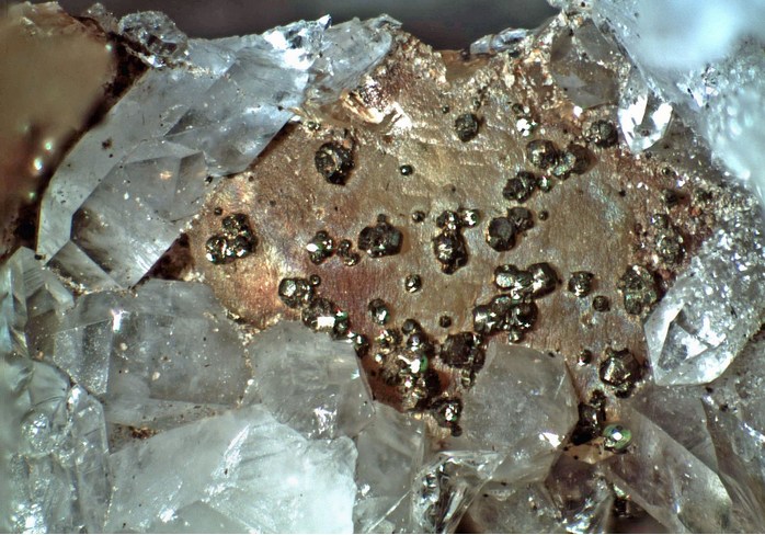


Gap Ridge Mine, Lake Greeson, Pike County, Arkansas, USA