 | | Report (issue) |
| STATE OF OREGON DEPARTMENT OF GEOLOGY AND MINERAL INDUSTRIES 329 SW. Oak Street Portland, Oregon Bulletin...No. 14-A Oregon Metal Mines Handbook By the Staff Bulletin No. No. 14-A Northeastern Oregon-East Half...Northeastern Oregon-West Half No. 14-C Southwestern Oregon No. 14-D Northwestern Oregon No. 14-E Central...Southeastern Oregon ----�- 1939 STATE GOVERNING BOARD W. H. STRAYER, CHAIRMAN BAKER ALBERT BURCH...• FOREWORD T HE ONLY handbook or catalog of Oregon mines ever published was issued in 1916-more than |
 | | Report (issue) |
| for advance publication] (A) Some mining districts of eastern Oregon, by James Gilluly, J. C. Reed, and...deposits of the Takilma-Waldo district, Oreg., including the Blue Creek district, by Philip J. Shenon________...deposits in the northwestern part of the Boise Basin, Idaho, by Clyde P. Ross_________________________...location of mining districts in eastern Oregon. 8 2. Topographic and geologic map of the Mormon Basin mining...mining district, Baker and Malheur Counties, Oreg _ 32 3. Geologic sketch of underground workings of Amalgamated |
 | | Report (volume) |
| ....................................... 102 District of Columbia .................................................................................. Oregon. ................................................to refer to Geological Survey Bulletin 507, "The mining districts of the western United States," and to...abundant it may have been completely exhausted by mining or quarrying. Deposits of minerals that are widely...because they occur in sufficient quantity to warrant mining for their usual products, but because they furnish |
 | | Report (volume) |
| it helpful to refer to Survey Bulletin 507, "The mining districts of the western United States," and to...abundant, it may have been completely exhausted by mining or quarrying. Deposits of minerals of wide distribution...because they occur in sufficient quantity to warrant mining for their usual products but because they furnish...Oberlb Oklahoma........Prof. D. W. Ohern, Norman. Oregon............Prof. A. J. Collier, Eugene. Pennsylvania...See Bauxite and Hallpysite. Asbestos. Tallapoosa County, with corundum deposits near Dudleyville; not found |
 | | Report (issue) |
| description of the geology, mining history, and production of the major gold-mining districts in 21 States...relations ---------------------------History of gold mining and trends in production_ J\labama -----------...--------------Cleburne County ----------~----------------- Tallapoosa County --------------------------Alaska...------------------Cochise County -----------------------------Gila County --------------------------------Greenlee...ee County ----------------------------R[aricopa County ----------------------------R[ohave County -- |
 | | Report (volume) |
| ........................ 5 5 Distribution of mining districts...................................................................................... Oregon........................................'................................. PART II. Catalogue of mining districts, by J. M. Hill..................................................... Classification of mining districts........................................j.............................................. Oregon............................................... |
 | | Report (volume) |
| 10 10 Genesee Valley............................................. 10 Indian Valley..................Meadows........................................ Jura Valley........................................................:............................ Swearinger slate............................................... Jurassic...limestone............................................ Mormon sandstone................................................................... 62 Cascade mine to Mohawk Valley........................ 62 Along Haskell |
 | | Journal (issue) |
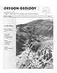
| OREGON GEOLOGY published by the Oregon Department of Geology and Mineral Industries VOLUME 53, NUMBER...to central Oregon , Part 1 Oil and gas exploration and development in Oregon, 1990 Mining and exploration...exploration in Oregon during 1990 Current mineral exploration activity ." MAY 1991 OREGON GEOLOGY (ISSN...March, M.ay, Jul). September, and Novemberby the Oregon Department of Geolog) and MIneral Industnes. (Volumes...ManagerlEditor Associate Editor . . . . . . . . Baker City . Myrtle Creek . . . Portland . Donald A. Hull |
 | | Book (edition) |
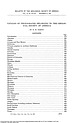
| YEAR 1687"—DAVID T. DAY, CHIEF OF THE DIVISION OF MINING STATISTICS AND TECHNOLOGY WASHINGTON GOVERNMENT...and consump tion, or better and cheaper means of mining, extraction, and convey ance to market, may in...correspondence has been carried on with geologists, mining engineers, and other local authorities, and various...mmed at Broken Arrow aud Trout creek, in Sc. Clair county. The strata in this field are more faulted und...prong of Canoe creek, in St. Clair county, to Ha\sop creek, in Bibb county, a distance of 60 miles. Down to |
 | | Report (volume) |
| interspersed with explanations of mountain and valley or statements of geologic history. In a broad way...route lies in the broad, well-watered Mississippi Valley, where an abundance of rainfall is indicated by...to the traveler, because the railroad follows a valley whose bottom lands in the arid part of the Great...moisture for growing crops. On both sides of this valley in western Nebraska the land is utilized for grazing...canyon cut by Weber River, and then enters the valley of Great Salt Lake. Leaving Ogden on the westward |
 | | Report (issue) |
| . . . . . . . . . . . . . . . . . . . Stevens County..................... ... . . . . . . . . . . ....Northport District. .... . ........ . .. ... . . . .. . . . ............ . Myers Fa.Us District . . . .... . . . . . . . . . . . . . . . . Fla.t C1·eek District . . . . . . . . . . . . . . . . . . . . . . .... . . . . . . . . . . . . . . . . . Colville District . . . . . . . . . . . . . . . . . . . . . . . ..... . . . . . . . . . . . . . . . . . Chewela.h,District . . . . . . . . . . . . . . . . . . . . . . . |
 | | Report (issue) |
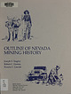
| wu OUTLINE OF NEVADA MINING HISTORY— Joseph V: Tingley a RobertC.Horton _ Francis C. Lincoln 3 . ...Publication of this new edition of “Outline of Nevada Mining History” was made — possible with the assistance...07 Uet a vA. | B13L40 —S OUTLINE OF NEVADA MINING HISTORY Joseph V. Tingley Robert C. Horton Francis...THE MINING HISTORY OF THE STATE OF NEVADA, by Francis Church Lincoln, 1924 Reese River district 14...14 White Pine district 14 Trinity district 16 Candelaria district 16 First bullion production 16 First |
 | | Report (issue) |
| an overall guide been written on gold and gold mining of publications have no single report or to...belt by Knopf and Logan, and reports on the Grass Valley, Alleghany, and Randsburg districts by Johnston...longer district Hulin, respectively. the principal features of each gold-bearing district are described...publications were written on various phases of gold mining. The reports of John Trosk, the first State Geologist...Commissioner of Mineral prepared reports of mine production and gold-mining Bureau, and later now the California |
 | | Book (edition) |
| - Temecula, CA 92589 (909) 699-4749 - 1994 Mining Guide TABLE OF CONTENTS INrRoDUCI'ION ••••••••.............................. . OK 1 - 2 OR 1 33 Oregon Pennsylvania ....... ... ............. .... .......... . 1994 Mining Guide INTRODUCTION IMPORTANT - PLEAsE READ! The 1994 GPM Mining Guide is designed...(normally listed from north to south), directions and mining commen ts; gold-producing areas, general prospecting...under 18 years of age. After purchasing a current Mining Guide, GPAA members may take family members with |
 | | Report (issue) |
| production and reserve grades source, fineness, mining methods, other economic commodities and general...is useful for analyzing the roles genetics and mining method have on placer grades and volumes. Deposits...Individual workings are not included if deposit or district data are presented. A deposit was subjectively...and areas in Alaska, including sluice and drift mining. 5. Some volumes were estimated from deposit...is listed as a mining method for many deposits. Most placer mining methods (drift mining, dredging, etc |
 | | Book |
| stumble over a valuable nugget and stake your own mining claim? Indeed it to is, and author book Jay...prospecting, he points out, is in abandoned mining districts, where valuable mineral ores are present...commercial ores and secondary minerals by state, county, township, and geologic range. For easy identification...RANSOM 1875-1948 An to the Eastern '‘Schoolmarm” Mining Camps of the Old West I I a s I \ h K... CONTENTS Preface ix PART I 1 Introduction to Mining and Mineralogy 2 Preparation for Mineral Collecting |
 | | Book (volume) |
| chalcedony, jasper and gem petrified wood. BUFFALO COUNTY KEARNEY, area gravel bars and pits along the Platte...townagate, chalcedony, jasper, petrified wood. CASS COUNTY WEEPING WATER, SE, on rd. to Nehawka, in the Snyderville...chalcedony, jasper, fossils. CHERRY COUNTY VALENTINE, in the Sandhills county along the Niobrara R. and Minnechaduza...gem qualityagatized and opalized wood. DAWES COUNTY CHADRON, in N part of Co. and as far W as Crawford...woods, etc. DAWSON COUNTY GOTHENBURG, in sand pitspetrified palm wood. DEUEL COUNTY CHAPPELL, all regional |
 | | Report (issue) |
| organization is carrying on for the direct advancement of mining interests throughout the country than can readily...material, iron. Spencer, A. C.; Salisbury.R.D.; slate, clay, sand and gravel, Kiimmel, H. B.; building...oil resources of the Santa Maria oil district, Santa Barbara County, Cal., by Ralph Arnold and Robert Anderson...Jordan,.jr. 338. The iron ores of the Iron Springs district, southern Utah, by C. K. Leith and E. C. Harder...Phalen. 350. Geology of the Rangely oil district, Rio Blanco County, Colo., with a section on the water supply |
 | | Journal (article/letter/editorial) |
| ......................................... 401 District of Columbia................................................................. 407 Maryland and District of Columbia............................................................................... 423 Oregon............................................................................................ 463 Mining operations.......................................main valley. Tree mountain in extreme rig h t; mountYoung on extreme left (No. 47). Rock basin on top |
 | | Report (issue) |
| Trip 3: Great"Basin Porphyry Cu-Mo Deposits: Yerington, Robinson, Hall, Bingham Canyon October, 1994...of the Arizona Geological society, society for Mining, Metallurgy and Exploration Inc., and the U. s...We also want to thank collectively, all of the mining companies and staff who graciously allowed us to...Talapoosa and Olinghouse districts and the Gooseberry mine. Northeast of Lovelock we pass through Roberts'...devitrified rhyolite glass and perlite forms the summit of Washington Hill east of the altered zone. Scattered |
 | | Report (issue) |
| Skagit County ... . ...... .. ....... . ............ . ... . ..... .. ... . .. 265 Cokedale District . ..... 266 Hamilton District ............................................ 266 King County. . . . . . . . ...Newcastle-Issaquah District ................................ . 261 Renton-Cedar River District .... .. .......269 Green River District ...... . ................... . .......... . ... 270 Pierce County ...............Wilkeson-Carbonado District. . . . . . . . . . . . . . . . . . . . . . . . . . . . . . . . . 272 Kittitas County . . |
 | | Report (volume) |
| H. MclNTYRE Papers presented at the Northwest Mining Association Convention, Spokane, Washington, Dec...bulletin ; 1658A-S) "Papers presented at the Northwest Mining Association Convention, Spokane, Washington, Dec...Congresses. I. Mclntyre, David H. II. Northwest Mining Association (U.S.). Convention (1983 : Spokane...Volcanic Subsidence in the Custer Graben, Custer County, Idaho, by D. H. Mclntyre and K. M. Johnson. 109...Douglas-Fir at the Red Mountain Stockwork, Yellow Pine District, Idaho, by J. A. Erdman, B. F. Leonard, and D |
 | | Book |
| mountains. Referred to the Committee on Mines and Mining and ordered to be printed. Treasury Department...general idea No official document in any gress of the mining interest on the Pacific slope. department of the...lowing points 1. The origin of gold and silver mining on the Pacific coast and present condition of that...diggings and quartz lodes. 3. Different systems of mining, machinery used, processes of reducing the ores...waste, and net profits. 4. Population engaged in mining, exclusively and in part, capital and labor employed |
 | | Report (issue) |
| org/details/reportofstatemin15cali CALIFORNIA STATE MINING BUREAU FERRY BUILDING, SAN FRANCISCO ^LETCHER...Statement xxiii Participation of the California State Mining Bureau in the Panama-Pacific International Exposition...Production General Features I. Alpine County. 5 6 6 , Mining Districts The Mogul and Monitor Districts...Hercules Company 14 23 Silver Mountain District Silver King District Mineral Water Grover's Hot Springs...27 27 27 , , Bibliography Chapter II, Inyo County. Introduction and Acknowledgments Location and |
 | | Report (volume) |
| BULLETIN 546 MINERAL RESOURCES OF SOUTHWESTERN OREGON BY J. S. DILLEE, WASHINGTON GOVERNMENT PRINTING........ Topography and physiography of southwest Oregon............ 1......... Geology.............................. Mineral production of southwestern Oregon................................ Lode mines and...... Blue River mining region......................................... Bohemia mining region....................... Mining conditions............................................ Greenback mine............ |


