 | | Journal (article/letter/editorial) | | (NMNS51066). figure 2 (leftI: Galena. Crawford mine, Pirher, Oklahoma, Tri-State district; 6' 2 cm across;...Figure 3 (opposite page): Galena, St. Joseph Lead mine, Viburnum, Missouri, Viburnum Trend district; 6...marcasite, pyrite, chalcopyrite, fluorite, barite, calcite, and quartz from these deposits. These minerals...large Pyra mid deposit became known as the X-15 mine). What the above figures do not show is that the...consist ing of galena, sphalerite, pyrite, and calcite. In 1965, for example, 364,168 tons of direct shipping |  | | Journal (article/letter/editorial) | | practically unknown mineralogically. ARTHUR E . SMITH 9118 C o n c h o Houston, T e x a s 77036 IN S...pegmatite was mined at Barringer Hill in Llano County in the early 1900s but was flooded by Lake Buchanan...from 1900 to the middle 1940s; but the Mariposa mine, which produced most of the rare minerals, ceased...that in the "Arkansas Mineral Locality Index" (Smith, 1988) and a modification of that in the "California...Locality Index" (Kampf et al., 1989). I have Arthur Smith, a consulting editor for Rocks & Minerals, is a |  | | Report (volume) | | ____________ __________ ___________ Schoolhouse mine and nearby prospects_ _ _ ______ __ _______ StonewalL___...______ __ __ __ ___ Prospects in and southwest of Stonewall Creek valley______ Hancock-Ferguson__________...________________ Prospects between Joshua Creek mine and Old Tavern prospect________________________...Descriptions of mines and prospects-Continued Campbell County-Continued Drinkard and nearby prospects _________________________... Nelson County, Va. Plans, projection, and section of the Stonewall mine, Appomattox County, Va. Geologic |  | Swayze, G. A., Clark, R. N., Goetz, A. F. H., Livo, K. E., Breit, G. N., Kruse, F. A., Sutley, S. J., Snee, L. W., Lowers, H. A., Post, J. L., Stoffregen, R. E., Ashley, R. P. (2014) Mapping Advanced Argillic Alteration at Cuprite, Nevada, Using Imaging Spectroscopy. Economic Geology, 109 (5) 1179-1221 doi:10.2113/econgeo.109.5.1179 | Journal (article/letter/editorial) | | growth, collapse, and resurgence of the nearby Stonewall Mountain volcanic complex between 8 and 5 Ma....argillic alteration formed along the margin of the Stonewall Mountain caldera. Introduction Remote sensing... Goldfield yon Can Rat Mount Jackson lls Stonewall Mountain Hi 37 o 30' Figure 2 Cuprite o ...to the inferred margin of the late Miocene-age Stonewall Mountain caldera in southwestern Nevada modified...the western margin of the Stonewall Mountain caldera (Figs. 1 and 2). Stonewall Mountain is one of a group |  | | Report (volume) | | . . . . . . . . . . . . . . . . . Cotter Basin mine . . . . . . . . . . . . . . . . . . . . . . . .............................................. . Stonewall Creek placers ..................................Geologic and aeromagnetic map of the Arrastra-Stonewall, Silver King-Falls Creek additions, Powell and...part of the Arrastra-Stonewall addition showing the location of the Cotter Basin mine and Copper Camp prospects.... . . . . . . . . . 14. Map of the Cotter Basin mine showing sample localities and resource blocks . |  | | Journal (article/letter/editorial) | | mineralization in the southwestern Nevada volcanic field, USA S t e p h e n B. C a s t o r a a n d S t e v e n...School of Mines, Universityof Nevada, Reno, NV 89557. USA bDepartment of Geological Sciences, Mackay School...School of Mines, Universityof Nevada, Reno. NV 89557, USA (Received August 27, 1991; accepted after revision...mineralization in the southwestern Nevada volcanic field, USA. Ore Geol. Rev., 7: 193-223. The southwestern Nevada...Mountain. Sedimentary-rock-hosted mineralization at Mine Mountain is spatially associated with a thrust fault |  | | Report (issue) | | Valley Rawhide Flats Roach Lake Ruby Lake Sheelite . Smith Cr ee k Valley Smoke Cree k Deser t Starr Va 11...Buffalo Valley 36. Newark Valley 8. Carl in Mine 37. North Spring Valley 9. Carson Sink 38....Sheelite 17. Dry Lake (36°2 7', ll4 °53 ') 46. Smith Cr eek Valley 18. Edward Creek Valley 47. Smoke...Lake 50. St eptoe Valley 22. Gabbs 51. Stonewall Flat 23. Goldfield 52. Stewart Valley 24...640 l calcite feldspar quartz l 4~ , l 0~ c l ay 3 m pit in playa center 10 20 4 calcite quartz |  | | Journal (article/letter/editorial) | | SAN DIEGO COUNTY 331 GEOLOGY AND MINERAL DEPOSITS OF THE JULIAN DISTRICT, SAN DIEGO COUNTY, CALIFORNIA...__ __ __ ______ __ __ __ ______ __ __ ____ 340 Stonewall Granodiorite _______ _________ ___ ______ ____...------- -------- ---- - - - -- ______ __ - 369 Other Mine r a l D e posits -- -- -- -- -- ------ -- - -------...Julian region, in the central part of San Diego County, , California, includes the Julian, Banner, several...other less important mining districts, and the Stonewall Mine on the Cuyamaca land grant. In addition to |  | | Journal (issue) | | . ..... 483 W. E. Wilson The Total Wreck Mine, Pima County, Arizona ............ .. ........... ......... .... ..... 507 L. Presmyk The Flux Mine, Santa Cruz County, Arizona .................................. 531 W. E. Wilson & M. Hay The Carlota Mine, Gila County, Arizona ............................. .....District, Mohave County, Arizona ............. .... ..... 569 M. Hay & D. Morris The Bagdad Mine, Yavapai County...L. Muntyan A Dream Pocket at the North Geronimo Mine, October 1996 ............. .... ... . 603 G. Godas |  | | Report (issue) | | Studies in the Cotter Basin Area, Lewis and Clark County, Montana Open-file report 75-72 1975 This report...STUDIES IN THE COTTER BASIN AREA, LEWIS AND CLARK COUNTY, MONTANA By David J. Grimes and Robert L. Earhart...vegetation in the Cotter basin area, Lewis and Clark County, Montana, shows anomalously high concentrations...about 1.5 miles (2.4 km) north of Stonewall Mountain in the Stonewall Mountain quadrangle, northwest Montana...resource evaluation studies of the proposed Arrastra-Stonewall Wilderness candidate area, Helena National Forest |  | | Report (issue) | | Nellis Air Force Base Bombing and Gunnery Range, Nye County, Nevada GEOLOGICAL SURVEY PROFESSIONAL Prepared...Nellis Air Force Base Bombing and Gunnery Range, Nye County, Nevada By E. B. EKREN, R. E. ANDERSON, C. L. ROGERS...age._-____-__--------------------Andesite of Stonewall Flat-_________--------Tuff of Tolicha Peak___...Timber Mountain Tuff__--_------------Basalt of Stonewall Mountain area _____ Younger rocks of Mount Helen___________...Nellis Air Force Base Bombing and Gunnery Range, Nye County, Nev__________________________________.._--_---_--_---_- |  | | Report (issue) | | THE LOS BURROS DISTRICT, MONTEREY COUNTY, CALIFORNIA. By JAMES M. HILL. INTRODUCTION. The following...district, in the southwestern part of Monterey County, Calif., are based on observations made during...Gorda properties and the caretaker at the Buclimo mine. The district lies on the west side of the rugged...rugged Coast Range, near the south line of Monterey County, in Tps. 23 and 24 S., R. 25 E. Mount Diablo meridian...along Spruce Creek, in the vicinity of the Gorda mine, and at the head of Alder Creek, near the Buclimo |  | | Journal (issue) | | and the search for ancient Kentish Man. Brightling Mine. visit to Canyonlands NP. visit to _5th June 2011...MLMS / MFMS 40th anniversary party North Western USA Fossil Sights #1 Obituary_Jim Greenwood Obituary_Joyce...Muck above the Chalk—a proposed talk North Western USA fossil Sights #2 The State of ‘Play’ – Black Gold...visit to Tunbridge Wells, Rusthall Common and Stonewall Park, 8th May, 2016. Obituary. Dr Raymond Casey...tiny creatures which build cells of chitin or calcite. The cells are united in networks or separate fronds |  | | Report (issue) | | doing injustice to the product of any particular mine. The sampling, which is by far the most important...that particular place. After being crushed in the mine to avoid loss of moisture and quartered in the usual...practically the same condition as it was in at the mine. As in this condition it may have included considerable...showing composition of the coal as it comes from the mine. 2. Air dried: Analysis of sample after it has been...samples. Ko. Town. County. Weld. 6371 Name of mine. White Ash. Location in mine. Section of coal |  | | Report (volume) | | ______________________________ Stonewall Flat_____________._____________________ Stonewall Mountain.________________________...Continued. ' Page. Region about Goldfield Continued. Stonewall Mountain Continued. General geology Continued...7. Section across north face of Stonewall Mountain through Stonewall Spring__________________________________...and eastern California. counties, Nev., and Inyo County, Cal. The topographic map is on a scale of 1: 253...Range. In 1899 Mr. J. E. Spun- went from Lida to Stonewall Spring and thence across the Cactus, Ktiwich, |  | | Journal (article/letter/editorial) | | coarse xline galena has been found in the Aleo lead mine in Cave-in-Rock, Hardin Co., III. INDIANA—Slender...13, Kans. "This petrified wood came from Barber County, Kansas. I am not sure of its exact location but...quarries on the reservation. I found white cubical calcite xls in vugs in the limestone, also variable pieces...Baltimore 22, Md., sent in a coarse xline, white calcite which he found in a vertical vein in a road cut...imprints of fern leaves at an abandoned oil shale mine southeast of the city."—note sent in by A/2C Lawrence |  | | Journal (article/letter/editorial) | | esville, Arkansas;Bradleyand Munroe Counties,Tennessee). D. F. HEWETT AND MICHAEL FLEISCHER 2....quartz,black (manganiferous) calcite,barite,fluorite,zeolites,and calcite. As a part of the presentinquiry...district,New Mexico, and the Aguila district, Mohave County,Arizona and severalother districts,have been closelystudied...following minerals: black calcite,zeolites,opal, fluorite, barite, calcite, quartz. Only rarely are morethan...district. Also, in the Little Florida Mountains, Luna County,New Mexico, three mineralbeltsmay be discerned;at |  | | Report (issue) | | faults _____ _ Germany fault zone ____________ _ Stonewall fault zone ____________ _ Crest fault ________...______ Nitt mine ___ . _ ______ · ---- -··---~--- ---- -----Graphic-Waldo or Ozark mine ___ ~ -------_____...Juanita mine ________ __________ . -· __ _ __ _ _ __ _ South Juanita (Juanita Extension) mine .______...tunneL ___________ .. _______ ______ _ Woodland mine __ ___ ______________ __ ___ .. ___ _ Cavern and...____________________ _ Stonewall tunnels __________________________ _ Ambrosia mine ______ :.. ____________________ |  | | Journal (article/letter/editorial) | | inches in size. Another contributor is David S. Smith, 25 Calle Belleza El Encanto, Tucson, Ariz. He has...collected on some mine dumps around Marble Peak in the Santa Catalina Mountains, in Pima County, Arizona. A...epidote which occurs in limonite as well as in calcite. Some of the epidote crystals range up to 21/2...taken from the Cherokee district placers in Butte County, California. Mineral Information Service, July...Mrs. G. C. Littlefield of Stonewall in old Campbell County (now Fulton County), sent in an interesting |  | | Journal (issue) | | Mimetite on Barite 5.1 cm, from the Rowley mine, Maricopa County, Arizona. Dick Morris collection; Jeff Scovil...Shannon Frank Sousa Marshall Sussman Chris Whitney-Smith Will Wilkinson Wendell Wilson .,---,.,...., Edwin...explore literally thousands of mineral occurrences, mine dumps and abandoned mines in the public domain administered...Heintzelman (1805-1880) shipped ore specimens from his mine to be exhibited at the Cincinnati Merchant's Exchange...traveled all the way from Philadelphia to Yuma County in order to gather more wulfenite and vanadinite |  | | Report (volume) | | Tenn. Dept. Conserv., Div. Geology Rept. Inv.-Tennessee Department of Conservation, Division of Geology...aquifers of the upper James River Valley, Brown County, South Dakota [abs.]: Geol. Soc. America Bull....pitchblende deposits in Golden Gate Canyon, Jefferson County, Colorado: U. S. Geol. Survey Bull. 1030-G, p....1890-1956. Cretaceous section, Medina County, Texas, to Val Verde County, Texas, in San Angelo Geol. Soc....Radioactive ages of minerals from the Brown Derby mine and the Quartz Creek granite near Gunnison, Colorado: |  | | Report (issue) | | ...............................56 Spotted Range-Mine Mountain structural zone.......................56...northwest Frenchman Flat...15 Map showing Spotted Range-Mine Mountain structural zone and included Quaternary...but it is flanked on the east by the Spotted Range-Mine Mountain structural zone, an area of numerous small...activity between Yucca Mountain and the Spotted Range-Mine Mountain zone. A continuing problem in evaluation...Basalts Miocene-Quaternary Tuff of Stonewall Flat Stonewall Mountain Thirsty Canyon Tuff Black Mountain |  | | Report (issue) | | MAGNETITE ORES OF WESTERN NORTH CAROLINA AND EASTERN TENNESSEE.1 By W. S. BAYLEY. INTRODUCTION. PRODUCTION AND...iron ores of western North Carolina and Carter County, Tenn., comprise brown hematite (limonite and possibly...Director; and the State Geological Survey of Tennessee, Wllbur A. Nelson, Director. 209 210 CONTRIBUTIONS...counties, N. C., the greater part from Cherokee County. In the earlier years of this century brown ore...magnetite came mainly from Cranberry, in Avery County, N. C. A small quantity has been contributed by |  | | Report (issue) | | GEOLOGY AND MINERAL RESOURCES OF SAN DIEGO COUNTY, CALIFORNIA By F. HAROLD WEBER JR., California...parts of several sections, by R. M. Stewart COUNTY REPORT California Division of Mines Ferry Building...CAMPBELL, Director AND GEOLOGY State Geologist COUNTY REPORT ^ Price $8.00 3 CONTENTS Page ABSTRACT...Land closed to prospecting and mining City and county zoning Water for mining operations Previous descriptions...49 49 50 50 51 Bismuth 51 Boron Bromine 51 Calcite (optical grade) Hilton deposit Cesium Clay, |  | | Journal (article/letter/editorial) | | ZINC-LEAD MINERALIZATION, USA DELBERT D. HARPER 526 Walker Blvd., Maryville, Tennessee 37803 AND DAVID M....districts in the United States include those in Tennessee, southeast Missouri, and the TriState area of...lead, copper and iron sulfides, fluorite, barite, calcite, dolomite, and quartz are the most abundant minerals...limestone) to ore-bearing structures in the East Tennessee district. DeVoto (1983) described the LeadvilleGilman...that within the southeast Missouri and eastern Tennessee districts. Gregg et al. (2001) have suggested |
|


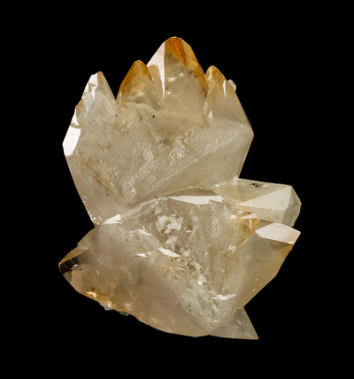
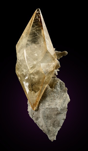


Stonewall Mine, Carthage, Smith County, Tennessee, USA