| Locality type: | Mountain |
| Classification |
|---|
|
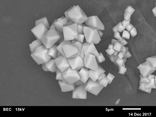
| Species: | Jarosite |
| Formula: | KFe33+(SO4)2(OH)6 |
| Confirmation |
|---|
|
| Validity: | Believed Valid |
| Data |
|---|
|
| Mineral Data: | Click here to view Jarosite data |
| Locality Data: | Click here to view Hinterschießling Alp, Scheffau am Wilden Kaiser, Kufstein District, Tyrol, Austria |
| Photo Gallery | View Gallery (2 photos) |
| Data Identifiers |
|---|
|
| Mindat Occurrence Record ID: | 1243962 |
| Long-form Identifier: | 1:3:1243962:1 |
| GUID (UUID V4): | a80c33ed-1e60-41ab-95d5-7508eab3bf8d |
| Nearest other occurrences of Jarosite |
|---|
|
|
| 10.9km (6.7 miles) | ⓘDiabase quarry, Oberndorf in Tirol, Kitzbühel District, Tyrol, Austria |
| 27.0km (16.8 miles) | ⓘGratlspitz, Brixlegg, Kufstein District, Tyrol, Austria |
| 28.9km (17.9 miles) | ⓘStocker adit, Silberberg, Geyer - Silberberg District, Brixlegg, Kufstein District, Tyrol, Austria |
| 35.4km (22.0 miles) | ⓘViertal Alp (Puderlehen Alp), Uttendorf, Zell am See District, Salzburg, Austria |
| 35.5km (22.1 miles) | ⓘBärenbad Mine, Scharnbachgraben, Hollersbach im Pinzgau, Zell am See District, Salzburg, Austria |
| 35.9km (22.3 miles) | ⓘHochfeld Mine, Neukirchen am Großvenediger, Zell am See District, Salzburg, Austria |
| 36.7km (22.8 miles) | ⓘKyanite-Quartzite outcrops, Leutachkopf - Stocker Alp area, Neukirchen am Großvenediger, Zell am See District, Salzburg, Austria |
| 48.7km (30.2 miles) | ⓘLechnerberg slag locality, Kaprun, Zell am See District, Salzburg, Austria |
| 71.7km (44.5 miles) | ⓘKaiserer quarry (Deisl quarry), Rauris, Zell am See District, Salzburg, Austria |
| 72.9km (45.3 miles) | ⓘLohning quarry (Lohninger quarry), Rauris, Zell am See District, Salzburg, Austria |
| References |
|---|
|
|


Hinterschießling Alp, Scheffau am Wilden Kaiser, Kufstein District, Tyrol, Austria