| Locality type: | Deposit |
| Classification |
|---|
|
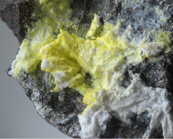
| Species: | Greenockite |
| Formula: | CdS |
| Confirmation |
|---|
|
| Validity: | Confirmed |
| Confirmation Methods: | Visually Identified |
| Associated Minerals Based on Photo Data: |
|---|
|
| Sphalerite | ⓘ2 photos of Greenockite associated with Sphalerite at this locality. |
| Hydrozincite | ⓘ1 photo of Greenockite associated with Hydrozincite at this locality. |
| Gypsum | ⓘ1 photo of Greenockite associated with Gypsum at this locality. |
| Data |
|---|
|
| Mineral Data: | Click here to view Greenockite data |
| Locality Data: | Click here to view Elisabeth mining district, Deutschfeistritz, Graz-Umgebung District, Styria, Austria |
| Photo Gallery | View Gallery (2 photos) |
| Data Identifiers |
|---|
|
| Mindat Occurrence Record ID: | 1294300 |
| Long-form Identifier: | 1:3:1294300:9 |
| GUID (UUID V4): | 2250a34a-e603-40c5-82bd-ee6eab0fd2db |
| Nearest other occurrences of Greenockite |
|---|
|
|
| 5.6km (3.5 miles) | ⓘUpper Topenauer adit, Notberg, Guggenbach, Übelbach, Graz-Umgebung District, Styria, Austria |
| 7.5km (4.6 miles) | ⓘUpper Ludwig adit, Ludwig district, Guggenbach-South, Guggenbach, Übelbach, Graz-Umgebung District, Styria, Austria |
| 8.2km (5.1 miles) | ⓘTalgraben, Frohnleiten, Graz-Umgebung District, Styria, Austria |
| 8.9km (5.5 miles) | ⓘFürst, Rechberg, Frohnleiten, Graz-Umgebung District, Styria, Austria |
| 14.7km (9.1 miles) | ⓘArzberg, Passail, Weiz District, Styria, Austria |
| 22.4km (13.9 miles) | ⓘKogl (Kogler), Sankt Kathrein am Offenegg, Weiz District, Styria, Austria |
| 24.6km (15.3 miles) | ⓘLead mine, Graschnitzgraben, Sankt Marein im Mürztal, Bruck-Mürzzuschlag District, Styria, Austria |
| 25.7km (16.0 miles) | ⓘStraßegg (Straßeck), Gasen, Weiz District, Styria, Austria |
| 32.1km (19.9 miles) | ⓘWiesergut Mine (Wieser Mine), Oberdorf magnesite deposit, Oberdorf (Oberdorf an der Laming), Tragöß-Sankt Katharein, Bruck-Mürzzuschlag District, Styria, Austria |
| 33.6km (20.9 miles) | ⓘKulmbach, Freienberg, Stubenberg am See, Hartberg-Fürstenfeld District, Styria, Austria |
| References |
|---|
|
|


Elisabeth mining district, Deutschfeistritz, Graz-Umgebung District, Styria, Austria