| Locality type: | Mine |
| Classification |
|---|
|
| Type: | Sandstone |
| Comments: | Carbonaceous sandstone of the basal Petrified Forest Member of the Chinle Formation. |
| Confirmation |
|---|
|
| Validity: | Believed Valid |
| Data |
|---|
|
| Mineral Data: | Click here to view Sandstone data |
| Locality Data: | Click here to view Ryan No. 1 Mine, Cameron, Cameron Mining District, Coconino County, Arizona, USA |
| Data Identifiers |
|---|
|
| Mindat Occurrence Record ID: | 1306426 |
| Long-form Identifier: | 1:3:1306426:6 |
| GUID (UUID V4): | e9e65969-18e3-4028-9263-877a1c17495a |
| Nearest other occurrences of Sandstone |
|---|
|
|
| 2.3km (1.4 miles) | ⓘNew Liba Mine (Pretty Girl), Cameron, Cameron Mining District, Coconino County, Arizona, USA |
| 2.6km (1.6 miles) | ⓘHuskon No. 10 Mine (Charles Huskon #10; Huskon #10), Huskon Mines (Huskon group), Cameron, Cameron Mining District, Coconino County, Arizona, USA |
| 2.6km (1.6 miles) | ⓘHuskon No. 11 Mine (Charles Huskon #11; Huskon #11), Huskon Mines (Huskon group), Cameron, Cameron Mining District, Coconino County, Arizona, USA |
| 3.0km (1.9 miles) | ⓘRamco No. 21 claim, Cameron, Cameron Mining District, Coconino County, Arizona, USA |
| 3.2km (2.0 miles) | ⓘRyan 2 Mine, Cameron Mining District, Coconino County, Arizona, USA |
| 3.6km (2.2 miles) | ⓘYazzie No. 105 Mine, Cameron, Cameron Mining District, Coconino County, Arizona, USA |
| 3.6km (2.2 miles) | ⓘJackpot No. 8, Cameron, Cameron Mining District, Coconino County, Arizona, USA |
| 3.7km (2.3 miles) | ⓘRamco No. 20 Mine (Ramco No. 20 claim), Cameron, Cameron Mining District, Coconino County, Arizona, USA |
| 4.5km (2.8 miles) | ⓘRamco No. 22 Mine (Ramco No. 22 claim), Cameron, Cameron Mining District, Coconino County, Arizona, USA |
| 4.8km (3.0 miles) | ⓘJackpot No. 6, Cameron, Cameron Mining District, Coconino County, Arizona, USA |
| References |
|---|
|
|
| Reference Search (possible matching items) |
|---|
 | | Report (issue) | | Cumberland, Hobart, and MapleValley Quadrangles, King County, Washington GEOLOGICAL SURVEY PROFESSIONAL PAPER...Cumberland, Hobart, and Maple Valley Quadrangles, King County, Washington By JAMES D. VINE GEOLOGICAL SURVEY...Pecora, Director Library of Congress cllltalog-card. No. 76-602415 For sale by the Superintendent of Documents...drift_____________ Landslide debris _____________________ ---_--- 1 2 2 2 2 4 4 4 4 4 6 6 6 6 13 13 16 16 19 23...Coal__________________________________________ Mining history_____________________________ Physical and | 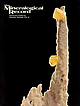 | | Journal (issue) | | locality. Pyromorphite from on old locality—rhe Sherman mine, Burke, Idaho. A small lot of miniatures and hondsize...specimens— $15 to $500. Liebigite from rhe SchwarTzwalder mine, Golden, Colorado. Well-formed, bright yellow-green...Woo Feature articles Libethenite from the Rokana Mine, Zambia...........................................Korowski and C. W. Notebart Quartz & Pyrite from King County, Washington......................................Hill Mine, Ogdensburg, New Jersey 385 by F. J. Parker Tveitite from the Barringer Hill District, Texas |  | | Report (issue) | | destroy or throw away this publication. If you have no further use for it write to the Geological Survey...Bulletin 849 B LODE DEPOSITS OF THE FAIRBANKS DISTRICT, ALASKA BY JAMES M. HILL Investigations in Alaska...History of mining.__________________________________________ Economic factors affecting mining.________..._-__________-__-___-.__-_______ Future of lode mining.____________________________________________ Index...ILLUSTRATIONS ,:,.. Page PLATE 3. Map of the Fairbanks district, Alaska, showing geology, claims, ditches, and |  | | Report (issue) | | 1 Petrol um Section Library CAMBRIAN AND ORDOVICIAN STRATIGRAPHY AND OIL AND GAS POSSIBILITIES IN INDIANA...Department of Conservation GEOLOGICAL SURVEY Bulletin No. 14 1958 STATE OF INDIANA HAROLD W. HANDLEY...CHARLES F. DEISS, STATE GEOLOGIST BLOOMINGTON BULLETIN NO. 14 CAMBRIAN AND ORDOVICIAN STRATIGRAPHY AND OIL................................... . Mt. Simon sandstone ............................................................... Correlation of the Mt. Simon sandstone ........................ . Eau Claire formation |  | | Report (issue) | | 50 CONTENTS Page Abstract 1 Introduction 1 Background for the report 1 New and old work 4 Acknowledgments...9 Overlying rocks 10 Carbonate buildups 12 Types 1, 2, and 3 carbonate rocks 15 Moccasin Springs Formation...19 19 20 20 22 23 25 ILLUSTRATIONS Page Figure 1 Chart showing nomenclature and correlation of the...is dominated by four kinds of carbonate rocks. ( 1) Reef rocks, fringing the deeper basin area and as...rocks and the New Harmony Group (Devonian) (fig. 1), deep within the Illinois Basin, were carried on |  | | Report (issue) | | CHARLES F. DEISS, STATE GEOLOGIST BLOOMINGTON BULLETIN NO. 2 PHYSIOGRAPHY OF THE LOWER WABASH VALLEY BY M...and braid cores . . . . . . . . . . . . . . Vigo County, Indiana . . . . . . . . . . . . . . . . . . .... . . . . . . . . . . . . . . . . . . Crawford County, Illinois . . . . . . . . . . . . . . . . . . .... . . . . . . . . . . . . . . . Lawrence County, Illinois . . . . . . . . . . . . . . . . . . . . . .... . . . . . • . . . • . • Knox County, Indiana . . . . . . . . . . . . . . . . . . . . . . . . . . . |  | | Report (issue) | | 47401 Price $1.00 Contents Abstract / 1 Introduction / 1 Earlier work / 7 Development, method, and...the Maquoketa Group from Wayne County on the eastern shelf to Newton County on the western shelf, showing...of the Maquoketa Group from Wayne County, Ind., to Iroquois County, Ill., based on radioactivity logs...section of the Maquoketa Group from Decatur County to Clark County, based on cores and showing correlation...of the Maquoketa Group from Steuben County, Ind., to Wabash County, Ill., based on electric and radioactivity |
|


