| Locality type: | Incline |
| Classification |
|---|
|
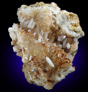
| Species: | Cerussite |
| Formula: | PbCO3 |
| Confirmation |
|---|
|
| Validity: | Believed Valid |
| Associated Minerals Based on Photo Data: |
|---|
|
| Baryte | ⓘ20 photos of Cerussite associated with Baryte at this locality. |
| Data |
|---|
|
| Mineral Data: | Click here to view Cerussite data |
| Locality Data: | Click here to view Brandy Bottle Incline (Brandybottle Mine), Old Gang Mines (AD Mines), Reeth, Fremington and Healaugh, Richmondshire, North Yorkshire, England, UK |
| Photo Gallery | View Gallery (13 photos) |
| Data Identifiers |
|---|
|
| Mindat Occurrence Record ID: | 15278 |
| Long-form Identifier: | 1:3:15278:3 |
| GUID (UUID V4): | 58c814a6-f8cf-44b4-9475-d763b07f8337 |
| Nearest other occurrences of Cerussite |
|---|
|
|
| 0.4km (0.2 miles) | ⓘFriarfold Rake, Old Gang Mines (AD Mines), Reeth, Fremington and Healaugh, Richmondshire, North Yorkshire, England, UK |
| 0.7km (0.4 miles) | ⓘNorth Rake, Old Gang Mines (AD Mines), Reeth, Fremington and Healaugh, Richmondshire, North Yorkshire, England, UK |
| 0.7km (0.4 miles) | ⓘForefield Rake, Old Gang Mines (AD Mines), Reeth, Fremington and Healaugh, Richmondshire, North Yorkshire, England, UK |
| 1.7km (1.1 miles) | ⓘSurrender Ground, Langthwaite, Arkengarthdale, Richmondshire, North Yorkshire, England, UK |
| 3.3km (2.1 miles) | ⓘKay Hushes, Langthwaite, Arkengarthdale, Richmondshire, North Yorkshire, England, UK |
| 5.6km (3.5 miles) | ⓘWindegg Edge, Langthwaite, Arkengarthdale, Richmondshire, North Yorkshire, England, UK |
| 7.4km (4.6 miles) | ⓘHarker Mine and Hushes, Reeth, Fremington and Healaugh, Richmondshire, North Yorkshire, England, UK |
| 12.2km (7.6 miles) | ⓘWet Grooves Mine (Wet Groves Mine), Carperby-cum-Thoresby, Richmondshire, North Yorkshire, England, UK |
| 18.6km (11.6 miles) | ⓘBirkett Common Mine, Mallerstang, Eden, Cumbria, England, UK |
| 23.0km (14.3 miles) | ⓘBishopdale Gavel, Buckden, Craven, North Yorkshire, England, UK |
| References |
|---|
|
|


Brandy Bottle Incline, Old Gang Mines, Reeth, Fremington and Healaugh, Richmondshire, North Yorkshire, England, UK