 | | Report (issue) | | FLUORITE OCCURRENCES IN UTAH by K. C. Bullock UTAH GEOLOGICAL AND MINERAL SURVEY a division of the UTAH...UTAH DEPARTMENT OF NATURAL RESOURCES BULLETIN 110 PRICE $4.50 DECEMBER 1976 Frontispiece: Purple...Purple pit fluorspar pipe, Lost Sheep mine, Spar Mountain, Juab County. CONTENTS Page Dell No. 5 Claim ...43 Floride Mine . . . . . . . . . . . . . . . . . . . . . . . . . . . . 43 Floride No. 1 Mine . . . . ...Floride No.5 Mine . . . . . . . . . . . . . . . . . . . . . . . 44 Floride No. 13 Mine . . . . . . . |  | | Report (volume) | | Fluorspar Deposits of Utah GEOLOGICAL SURVEY BULLETIN 1005 Fluorspar Deposits of Utah By W. R. THURSTON...in cooperation with the State of Utah through the University of Utah. This report concerns work done partly... ________ ___________ History of fluorspar mining in Utah __ --__-_________--_____--___ Classification..._____ Deposits in Indian Peak Range and Monarch claims, Beaver County, by W. R. Thurston. __ ____ _______...mine__________________________--_.___-____ Blue Bell mine...-- ____ _____ - __ __ _ ___________ Noonday |  | | Report (volume) | | Geology of the Thomas Range Fluorspar District Juab County, Utah GEOLOGICAL SURVEY BULLETIN This report...Commission 1069 Geology of the Thomas Range Fluorspar District Juab County, Utah By M. H. STAATZ and F. W....INTERIOR FRED A. SEATON, Secretary GEOLOGICAL SURVEY Thomas B. Nolan, Director The U. S. Geological Survey...Mortimer Hay, 1918Geology of the Thomas Range fluorspar district, Juab County, Utah, by M. H. Staatz and F. W...Geology Utah Juab Co. 2. Fluorspar. i. Osterwald, Frank W., joint author. 11. Title: Thomas Range fluorspar |  | | Report (volume) | | Geology of the Beryllium Deposits in the Thomas Range Juab County, Utah By MORTIMER H. STAATZ CO~~TRIBUTIONS...STEWART L. UDALL, Secretary GEOLOGICAL SURVEY Thomas B. Nolan, Director For sale by the Superintendent...Geologic map of the southwestern part of the Spor Mountain area ______________________________________________...of the Thomas Range__________________________ 2. Distribution of mineral deposits in the Spor Mountain...GEOLOGY OF THE BERYLLIUM DEPOSITS IN THE THOMAS RANGE, JUAB COUNTY, UTAH By MORTIMER H. STAA'l'Z ABSTRACT |  | | Report (issue) | | of the resource areas in the Basin and Range Province of Utah by George Wong Open-File Report 83-722...Table 1. District descriptions Preliminary map of the resource areas in the Basin and Range Province...Province of Utah By George Wong The purpose of this map is to identify the mineralized areas within the Basin...Basin and Range Province. These areas include past or present mining and prospecting activity as well as...map are not legal mining district boundaries and may include more than one district as well as adjacent |  | | Report (issue) | | CALITI ES OF UTAH by Kenneth C. Bullock UTAH GEOLOGICAL AND MINERAL SURVEY a division of the UTAH DEPARTMENT...JANUARY 1981 MINERALS AND MINERAL LOCALITIES OF UTAH by Kenneth C. Bullock Nature displays her most.... . . . . . 1 Chapter I. Mining Districts of Counties and the State of Utah. . . . . . . . . . . . .... . . . . . . . . . . . . . . . . . . . . . . 1 County Listings. . . . . . . . . . . . . . . . . . . .... . . . . . . . . . . . 1 Chapter II. Mining Districts of Utah . . . . . . . . . . . . . . . . . . . |  | | Report (issue) | | Mineral Deposits of the Thomas and Dugway Ranges Juab and Tooele Counties Utah By MORTIMER H. STAATZ and...STEWART L. UDALL, Secretary GEOLOGICAL SURVEY Thomas B. Nolan, Director The U .8. Geological Survey...Cambrian age_~-----------------------Prospect Mountain quart2ite (Lower Cambrian)_ Cabin shale (Lower...Rocks of Silurian age____________________________ Bell Hill dolomite (Middle Silurian) _____ -·-____ Harrisite...Woodman formation (Upper Mississippian)____ Ochre Mountain limestone (Upper Mississippian)-------------- |  | | Report (issue) | | Selected Mining Districts of Utah by Carl L. Ege Headframe of Centennial Eureka mine, Tintic mining district...MISCELLANEOUS PUBLICATION 05-5 UTAH GEOLOGICAL SURVEY a division of 2005 Utah Department of Natural Resources...Resources STATE OF UTAH Jon Huntsman, Jr., Governor DEPARTMENT OF NATURAL RESOURCES Michael Styler, Executive...Executive Director UTAH GEOLOGICAL SURVEY Richard G. Allis, Director PUBLICATIONS contact Natural Resources...toll-free: 1-888-UTAH MAP website: http://mapstore.utah.gov email: geostore@utah.gov THE UTAH GEOLOGICAL SURVEY |  | | Report (issue) | | Studies of Geology and Hydrology in the Basin arid Range Province, Southwestern United States^ For Isolation...Waste Characterization of the Bbnneville Region, Utah and Kevadt U.S. GEOLOGICAL StJ&VEY Pi*0£ESSIO&AL... STUDIES OF GEOLOGY AND HYDROLOGY IN THE BASIN AND RANGE PROVINCE, SOUTHWESTERN UNITED STATES, FOR ISOLATION...WASTECHARACTERIZATION OF THE BONNEVILLE REGION, UTAH AND NEVADA Looking north of Blue Lake Springs...margin of the Great Salt Lake Desert, Tooele County, Utah. Springs at and near Blue Lake Springs discharge |  | | Journal (article/letter/editorial) | | BERYLLIUM-BEARING TUFF IN JUAB COUNTY, MORTIMER H. STAATZ AND THE THOMAS RANGE, UTAH • WALLACE R. GRIFFITTS............ 943 946 948 Potentialities of the district ........................................... References...depositsin the Thomas Range, Utah, are along the periphery of the fluorspar district at Spor Mountain. The beryllium...age and is associatedwith genetically related fluorite, quartz, chalcedony,opal, calcite, and montmorillonite... feldspar, and biotite. Nodules of silica and fluorite contain more beryllium than the enclosingtuff |  | | Report (issue) | | Tertiary Volcanic Rocks and Uranium in the Thomas Range Northern Drum Mountains, GEOLOGICAL SURVEY PROFESSIONAL...Rocks and Uranium in the Thomas Range and Northern Drum Mountains, Juab County, Utah By DAVID A. LINDSEY ...Crystal tuff member Landslide breccias Breccia at Spor Mountain and breccia at Wildhorse Spring . Megabreccia...Continued Topaz Mountain Rhyolite Continued Stratified tuff Structural geology Thomas caldera 29 29 ...tuff member of the Spor 47 50 51 Uranium in stratified tuff of the Topaz Mountain Rhyolite A model for |  | | Journal (article/letter/editorial) | | MINERALIZATION IN TUFFS, HONEY COMB HILLS, JUAB COUNTY, UTAH McANULTY AND A. A. LEVINSON ABSTRACT... Rare alkali (Cs, Rb, and Li), beryllium, and fluorite mineralization occur together in tuffs and tuffaceous...Hills, Juab County, Utah, in an environment similar to that of the betterknown Spor-Topaz district in the...aroundthe Honey CombHills, Fish Creek District, Juab County, Utah, led to a geologicaland exploration project...single,rhyolite-capped mesa or larger butte. Bell Hill, the smallerof the two, is circularin plan,whereasthe |  | | Report (issue) | | INTERIOR STEWART L. UDALL, Secretary GEOLOGICAL SURVEY Thomas B. Nolan, Director For sale by the Superintendent...between footwall and hanging wall seams, Carroll mine.______--_-_____________________________________...Cross section through Crooks Gap area, Fremont County, Wyo__ __________-______-___--_--__------------_...roll, Rex No. 1 mine- ______ 50. Fault in back of stoped-out ore roll, Rex No. 1 mine- ___---___-_---...of Eocene age in uplifted fault block at RanRex mine.- _____________________________________________ |  | | Report (issue) | | INTERIOR STEWART L. UDALL, Secretary GEOLOGICAL SURVEY Thomas B. Nolan, Director .72 36 5 6 '%09 ~ {),7'1 ...STEWART L. UDALL, Secretary GEOLOGICAL SURVEY Thomas B. Nolan, Director ·~- For sale by the Superintendent...Classification of uranium-bearing veins _______________ _ Fluorite-bearing veins __________________________ _ Base-metal...predecessor organization, the Manhattan Engineer District ; and, to a lesser extent, by staff members of...United States. The pre-1940 history of uranium mining and geology is concerned largely with veins in |  | | Report (volume) | | INTERIOR FRED A. SEATON, Secretary GEOLOGICAL SURVEY Thomas B. Nolan, Director For sale by the Superintendent...most important were those in the Central City district, Colorado, from which about 300 tons of high-grade...Silver Cliff mine, Wyoming; the Jesse D No. 1 and No. 2 claims, Utah; and the Merry Widow mine, New Mexico...important discoveries are the deposits at Marysvale, Utah; the Schwartzwalder (Ralston Creek) and Los Ochos...mines, Washington; the W. Wilson mine, Montana; the White King mine, Oregon; the deposits in the Pryor |  | | Report (volume) | | INTERIOR FRED A. SEATON, Secretary GEOLOGICAL SURVEY THOMAS B. NOLAN, Director For sale by the Superintendent...Geophysical Union.. Transactions, American Institute of Mining and Metallurgical Engineers _..._ American Journal...Colorado Mining Association publications . Economic Geology. _ . _ ___... Engineering and Mining Journal...of Sedimentary Petrology_...__._ Mines Magazine Mining Engineering ........___..._...._____ Advances in...Report ____________ ___._ Utah Geological and Mineralogical Survey.... Utah Geological Society, Guidebook | 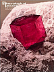 | | Journal (issue) | | Record Articles The Thomas Range, Wah Wah Mountains, and vicinity, western Utah .......................Violet #5 claim , Wah Wah M oun tains, Beaver County, Utah. The crystal is about 1 cm in size. John Barlow...mineral localities: 1he Thomas Range, WahWall Mountains, vicn ty, Western and Utah by Lanny R. Ream P...83864 he rhyolites o f westcentral and southwestern Utah comprise one o f North America’s most interesting...With the boom in the mineral collecting hobby, the range has become increasingly popular with collectors |  | | Book (volume) | | Plains state varies from nearly level farmland to hill ridges, increasing steadily in elev. From 1,000’...rocks are exposed as thick bands around the entire mountain system. The rising granite mass intruded the famed...an inexhaustible supply of cold artesian, Rocky Mountain snow melt water. Harney Peak is the crest of the...instance, a single Spodumene crystal from the Etta Mine near Keystone on the east side of the Mount Rushmore...beds, excavations, etc.Selenite roses. BRULE COUNTY AREA: in the Oacoma zone of the Pierre Fm. On Elm |  | | Journal (article/letter/editorial) | | Similarcorrosion andcollapse featuresare notedin non-fluorite oredeposits, buttheyareneithersowidespread n...Cordilleranregionof the westernUnited States, fluorite-bearing mineral bodies forma significant groupofdeposits...EAGLE MTNS. ß FLUORSPAR MINE OR GROUP OF MINES FLUORITE OCCURRENCE ß FLUORITE IN THE WESTERN UNITED...Colorado;Salida-Poncha Passarea, Colorado; ThomasRange,Utah; Darbyarea,Montana. Although thecurrent marketdoesnotencourage...fluorspar deposits in thewestern UnitedStates, thelong-range requirements forfluorspar justifycontinued investigation |  | | Book (volume) | | ae TONITE TN263. Au. =American Institute of Mining, Metallurgical, V.2 and Petroleum Engineers Ore...Inst! itute i an Americ ie Lye 2 of llurgical, Mining, Meta m Engineers and Petroleu © f the Ore deposiits...Graton-Sales Volume Other Volumes in the Rocky Mountain Fund Series CONFERENCE ON REVERBERATORY SMELTING...(1933) AIME TRANSACTIONS VOLUME AIME TRANSACTIONS MINE PLANT VOLUME 112, MILLING METHODS (1933) (1934)...AND ZINC (1936) 134, MILLING METHODs 141, METAL MINING (1939) (1937-40) BLAST FURNACE, COKE OVEN AND |  | | Report (issue) | | INTERIOR Secretary of the Interior GEOLOGICAL SURVEY Thomas B. Nolan, Director For sale by the Superintendent...· as a joint program of the Manhattan Engineer District and its successor, the U. S. Atomic Energy Commission...of Raw Materials U.S. Atomic Energy Commission Thomas B. Nolan Director, U. S. Geological Survey III...S. Altschuler George E. Becraft Henry Bell, III Kenneth G. Bell Rudolph A,. Black Irving A. Breger Robert...Klepper • Huh'ert William. Lakin Esper S. Larsen, Jr. Thomas S. Lovering J. Hoover Mackin William J. Mapel Harold |  | | Report (issue) | | INTERIOR FRED A. SEATON, Secretary GEOLOGICAL SURVEY Thomas B. Nolan, Director The TJ. S. Geological Survey..._________________ ___. Nevada ___________ Elko County. - ______ ... _ Star mine, Harrison Pass _____ ____ Pag« 59...63 Good Hope barite mine, Tuscarora Range _____ _ ._. ________ Humboldt County Golconda manganese-tungsten...County__-__--__----__-.___-_-__ Barite deposits, Battle Mountain area.. California-Nevada Barite Co. 63 64 64...Ltd., mine...... --_--______.______ Lincoln County__-__-----_-----_-----___ Tern Piute district...... |  | | Book | | Mineralogy University of ~1ichigan .. 1958 McGRAW-HILL BOOK COMPANY, INC. NEvV YORK TORONTO LONDON ~...RADIOACTIVE RAW MATERIALS Copyright © 1958 by the McGraw-Hill Book Con1pany, Inc. Printed in the United States...of vvhich 70% is in New Mexico, 16% in Colorado, Utah, and Arizona, and 8% in Wyo1ning. These figures...doubtless the U.S.S.R., likewise established uranium mining industries. These efforts in the Reid and in the...................................... . Calcite-Fluorite-Apatite Vein-Dikes .......................... |  | | Report (volume) | | STEWART L. UDALL, Secretary GEOLOGICAL SURVEY Thomas B. Nolan, Director For sale by the Superintendent...the future: Just, E. ing: Burwell, E. B., Jr., 4. Mining geology, retrospect and Index fossils: Stephenson...Moody, C. L., 3. 19th, 1952 : Alvarez, M., Jr.,6. Mountain-building, chronology, Iowa, ground water, geologic...Hershey, H. G. , 2. scale: Spieker, E. M., 3. Iron-range rocks, origin: Tanton, Distribution in geologic...Mexico: Guzman Jimenez, E. J., petroleum geology: Thomas, Horace D., 10. 9; Salas, G. P., 3. 1951: Moody |  | | Report (volume) | | STEWART L. UDALL, Secretary GEOLOGICAL SURVEY Thomas B. Nolan, Director For sale by the Superintendent... ore deposition: Butler, B. S. Minnesota, Cook County, titaniferous magnetite: Grout, F. F. Pennsylvania... Iron, Cook County, titaniferous magnetite: Grout, F. F. IRON. Minnesota, Cook County, titaniferous...society. A.I.M.E. Trans.-American Institute of Mining, Metallurgical, and Petroleum Engineers Transactions...University Research Studies Geology Series. Provo, Utah. British Columbia Dept. Mines Ann. Rept.; Bull.-British |
|

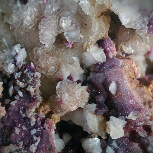


Bell Hill Mine, Spor Mountain Mining District, Thomas Range, Juab County, Utah, USA